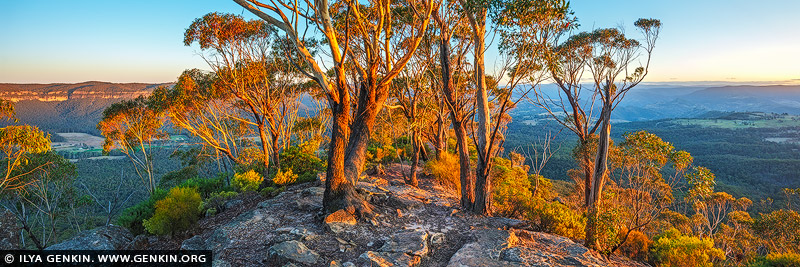
Hanging Rock at Sunrise, Baltzer Lookout, Blackheath, Blue Mountains, NSW, Australia 12 Apr 9:21 PM (5 days ago)
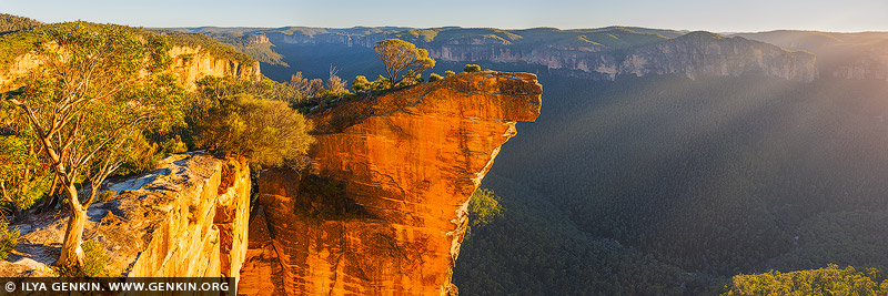
Hanging Rock at Sunrise, Baltzer Lookout, Blackheath, Blue Mountains, NSW, Australia.
This panoramic photograph captures the dramatic sandstone cliffs of Hanging Rock at sunrise, viewed from the breathtaking Baltzer Lookout near Blackheath in the Blue Mountains, NSW. As dawn breaks, the first light of day spills across the rugged escarpment, igniting the golden tones of the ancient rock and casting long shadows into the deep Grose Valley below. The sheer drop of Hanging Rock - balanced precariously at the edge - adds a thrilling sense of scale and solitude. Low-lying mist drapes the valley floor, creating a mystical contrast against the fiery sky, while eucalyptus trees catch the warm glow, their outlines etched sharply against the horizon. This image is a tribute to the raw beauty and geological grandeur of one of Australia's most iconic wilderness lookouts.


Torii Gate of the Toyosaki Konpira Shrine, Shosanbetsu, Hokkaido, Japan #2 3 Jan 6:07 PM (3 months ago)
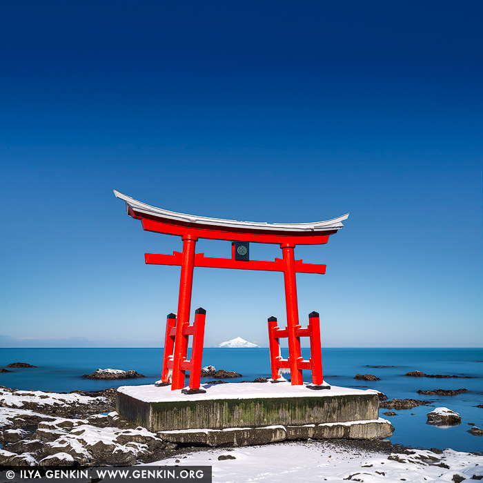
Torii Gate of the Toyosaki Konpira Shrine #2, Shosanbetsu, Hokkaido, Japan.
A stunning photograph captures the Torii Gate of Toyosaki Konpira Shrine in Shosanbetsu, Hokkaido, Japan. The iconic red gate stands tall against a backdrop of the endless Sea of Japan, its vibrant vermilion hue contrasting beautifully with the azure sky and deep blue waters. The gate's clean, symmetrical lines frame the view beyond, evoking a sense of serenity and connection to the natural world. On the horizon, Mount Rebun on Rebun Island rises majestically, its silhouette adding depth and a sense of distant wonder to the composition. The coastal breeze gently rustles the grasses in the foreground, adding a touch of motion to the scene. The soft light of early morning or late afternoon bathes the gate in a golden glow, enhancing the spiritual and tranquil atmosphere of this sacred location.

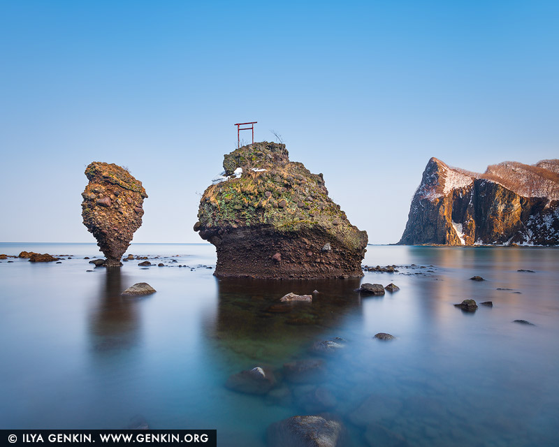
Torii Gate of the Toyosaki Konpira Shrine, Shosanbetsu, Hokkaido, Japan #3 3 Jan 6:06 PM (3 months ago)
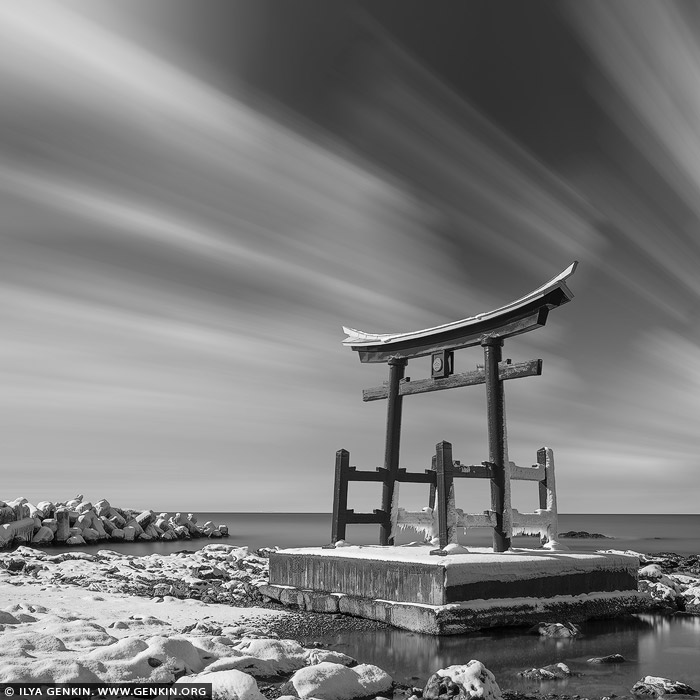
Torii Gate of the Toyosaki Konpira Shrine, Shosanbetsu, Hokkaido, Japan.
The Torii Gate of the Toyosaki Konpira Shrine in Shosanbetsu, Hokkaido, Japan, is a striking symbol of spiritual passage and cultural heritage. Perched along the coastline with the Sea of Japan as its backdrop, the vibrant vermilion gate creates a captivating contrast against the deep blue waters and the wide expanse of sky. This Torii, standing as a sentinel to the sacred grounds beyond, frames breathtaking views. The location's serene and remote setting adds to the shrine's tranquil atmosphere, inviting visitors to pause and reflect amid the harmony of nature and spirituality. The site is particularly enchanting during the golden hours of sunrise or sunset, when the gate is bathed in warm light, amplifying its timeless beauty and the profound sense of connection to the surrounding landscape.

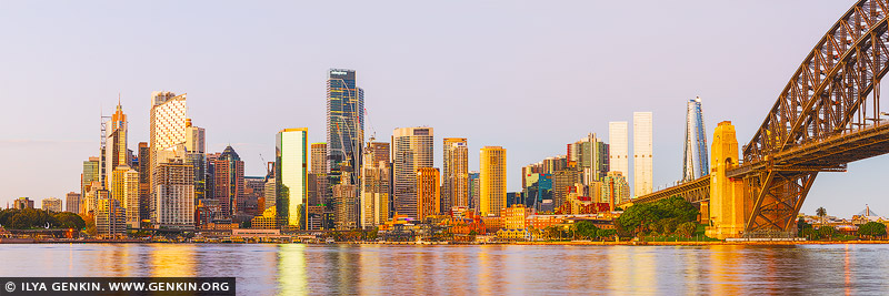
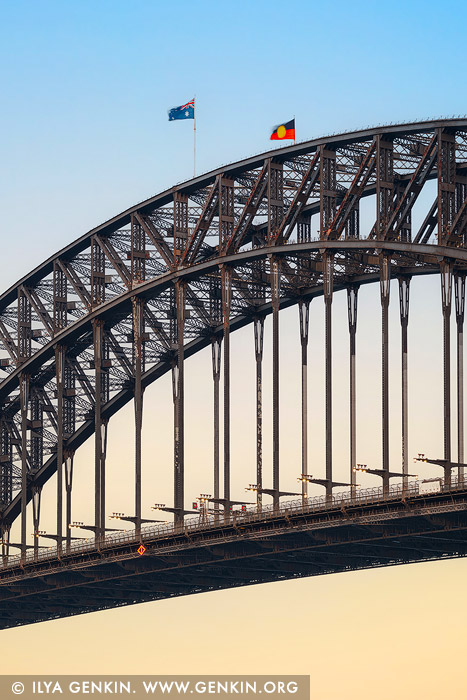
Panorama of the Sydney Harbour Bridge Silhouette, Sydney, New South Wales, Australia 27 Dec 2024 8:14 PM (3 months ago)
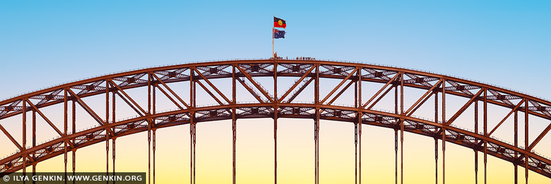
Panorama of the Sydney Harbour Bridge Silhouette, Sydney, New South Wales, Australia.
This panoramic photograph captures the striking arches of the Sydney Harbour Bridge glowing in red as they pierce a serene sky of pale yellow and soft blue. The unique lighting creates an enchanting contrast, with the fiery arches standing out dramatically against the tranquil hues of the sunset. Only the uppermost curves of the bridge are visible, their bold color and elegant form drawing the eye across the expansive composition. This captivating scene highlights the interplay of light, color, and structure, offering a fresh and artistic perspective on Sydney's iconic landmark.

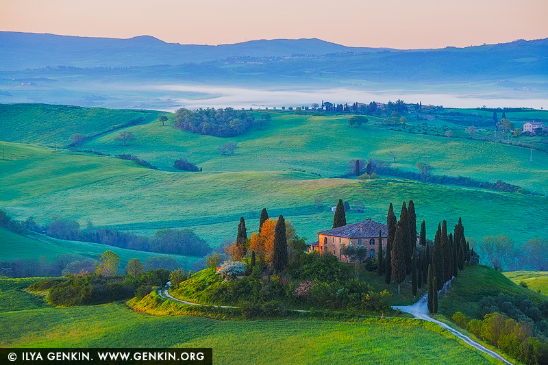
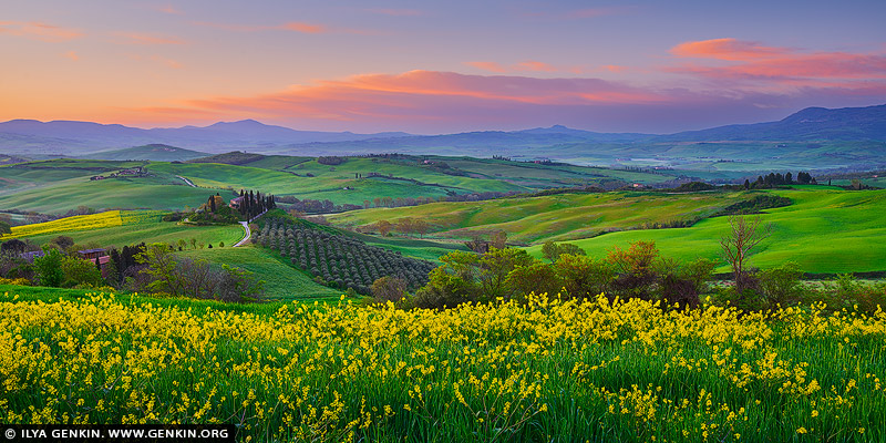
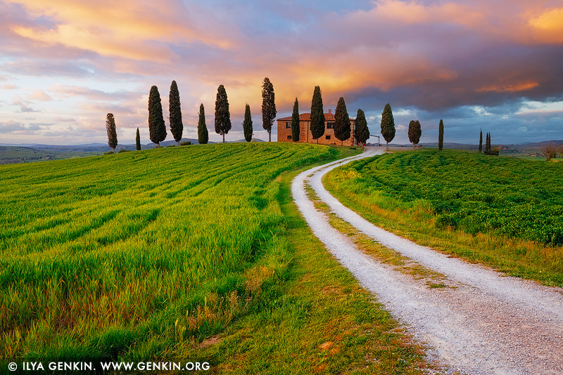
Podere Belvedere at Sunrise, Pienza, Val d'Orcia, Tuscany, Italy 1 Dec 2024 12:23 PM (4 months ago)
Podere Belvedere at Sunrise, Pienza, Val d'Orcia, Tuscany, Italy.
A breathtaking view of Val d'Orcia near Podere Belvedere in Pienza, Tuscany, at sunrise. Rolling hills stretch into the distance, blanketed in a soft morning mist that lends an ethereal quality to the scene. The iconic farmhouse of Podere Belvedere sits perched on a hill, surrounded by cypress trees and lush green fields kissed by the golden light of dawn. The sky is a canvas of warm hues, transitioning from soft pinks and oranges to deep blues, creating a perfect backdrop for this tranquil and timeless Tuscan landscape.

Val d'Orcia at Dawn, Pienza, Val d'Orcia, Tuscany, Italy 1 Dec 2024 12:22 PM (4 months ago)
Val d'Orcia at Dawn, Pienza, Val d'Orcia, Tuscany, Italy.
A serene early morning view of the Val d'Orcia landscape near Pienza, Tuscany, just before sunrise. A lavender fog drapes over the rolling hills, softening their contours and creating a dreamlike atmosphere. Lush green fields peek through the mist, adding vibrant contrast to the tranquil scene. Clusters of cypress trees and a nearby farmhouse emerge from the fog, offering texture and depth to this intimate glimpse of the Tuscan countryside at its most peaceful.

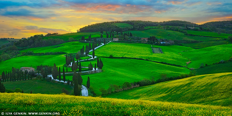
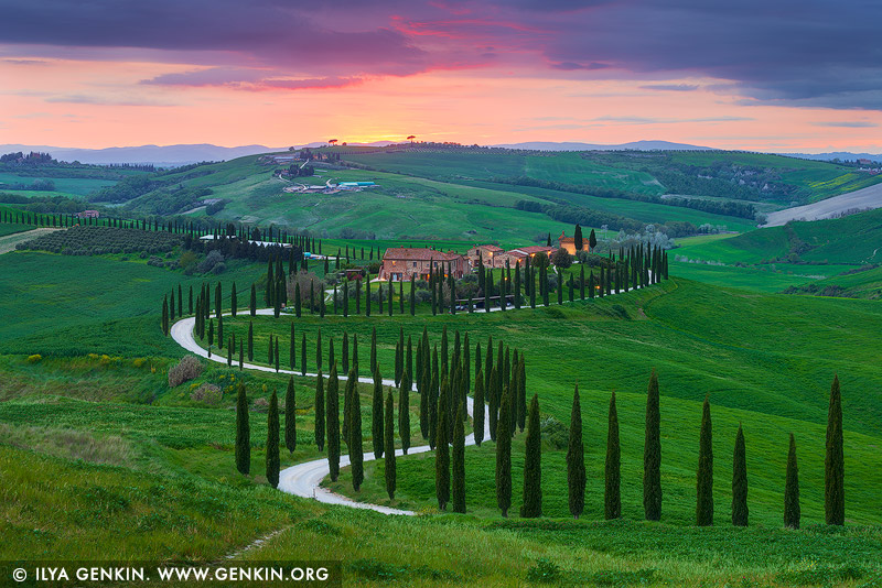
Vivid Sunset at Baccoleno, Crete Senesi, Tuscany, Italy 1 Dec 2024 12:22 PM (4 months ago)
Vivid Sunset at Baccoleno, Crete Senesi, Tuscany, Italy.
Baccoleno is a picturesque farmhouse nestled in the rolling hills of Crete Senesi, Tuscany, Italy. Renowned for its iconic cypress-lined winding driveway, it is surrounded by lush green fields and breathtaking landscapes. This idyllic location perfectly embodies the timeless beauty and charm of the Tuscan countryside. A stunning panoramic view of Baccoleno captured at sunset. The vibrant sky is ablaze with fiery hues of red, orange, and yellow, casting a warm glow over the rolling hills. The lush green fields of grass and crops stretch endlessly, their vivid tones enriched by the golden light. The iconic winding cypress-lined driveway leads to the charming farmhouse, perfectly framed within the dramatic landscape. The harmonious blend of nature's colours and Tuscany's timeless charm creates an unforgettable and mesmerising scene.

Podere Belvedere at Dawn, Pienza, Val d'Orcia, Tuscany, Italy 1 Dec 2024 12:21 PM (4 months ago)
Podere Belvedere at Dawn, Pienza, Val d'Orcia, Tuscany, Italy.
A tranquil view of Podere Belvedere in Pienza, Tuscany, captured just before sunrise. The farmhouse sits gracefully atop a hill, surrounded by cypress trees and rolling fields. Morning fog layers the distant hills, creating a soft, dreamy atmosphere. The muted light of dawn enhances the serenity of the scene, highlighting the gentle textures of the landscape and evoking the timeless charm of the Tuscan countryside.

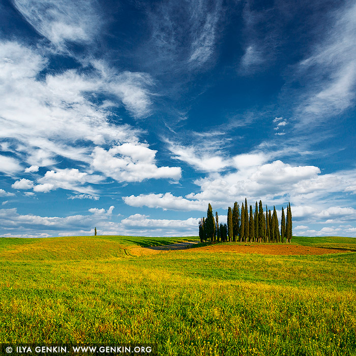
Cipressi di San Quirico d'Orcia #2, Val d'Orcia, Tuscany, Italy 1 Dec 2024 12:20 PM (4 months ago)
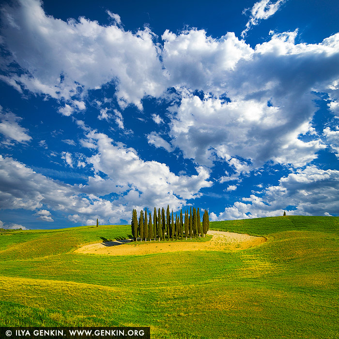
Cipressi di San Quirico d'Orcia #2, Val d'Orcia, Tuscany, Italy.
Cipressi di San Quirico d'Orcia is an iconic group of cypress trees located in the heart of Tuscany, Italy. Set atop a gentle hill and surrounded by rolling landscapes, it is a symbol of the region's timeless beauty and a favourite subject for photographers and visitors alike. A captivating afternoon view of Cipressi di San Quirico d'Orcia, nestled in the heart of Tuscany. The iconic cluster of cypress trees stands tall and proud at the center of the composition, framed by gently rolling green hills. The vibrant blue sky above is dotted with fluffy white clouds, adding depth and contrast to the scene. The sun bathes the landscape in warm, natural light, highlighting the vivid colours and timeless beauty of this serene countryside setting.

Lonely Cypress Tree at San Quirico d'Orcia, Val d'Orcia, Tuscany, Italy 1 Dec 2024 12:20 PM (4 months ago)
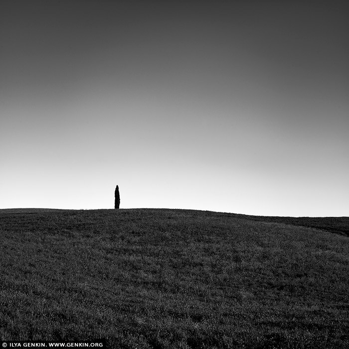
Lonely Cypress Tree at San Quirico d'Orcia, Val d'Orcia, Tuscany, Italy.
A striking black-and-white minimalistic composition capturing a solitary cypress tree atop a gentle hill in San Quirico d'Orcia, Tuscany. The clean, sweeping lines of the hill contrast with the stark silhouette of the cypress, creating a sense of solitude and elegance. The absence of color emphasises the textures and forms, drawing attention to the timeless simplicity of the Tuscan landscape.

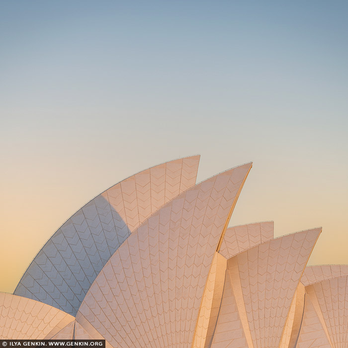
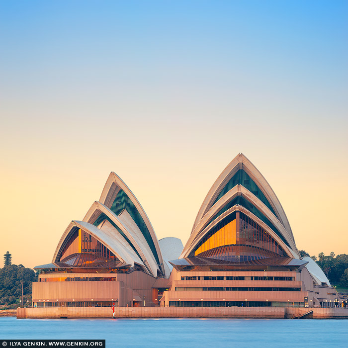
Sydney Opera House Sails at Dawn, Sydney, NSW, Australia 29 Nov 2024 7:52 PM (4 months ago)
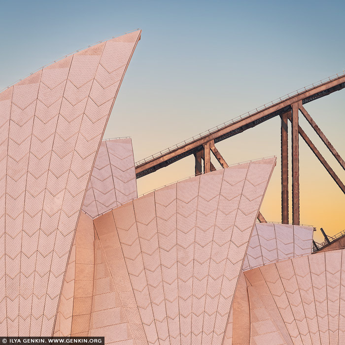
Sydney Opera House Sails at Dawn, Sydney, NSW, Australia.
An intimate close-up of the Sydney Opera House sails, their iconic, curving white tiles bathed in the soft golden and pink hues of sunrise. The intricate texture of the sails is illuminated, showcasing their delicate yet striking architectural detail. In the background, a portion of the Harbour Bridge arches gracefully into the frame, its steel structure silhouetted against the pastel-coloured sky. The interplay of light and shadow captures the tranquil beauty of this early morning moment in Sydney.

Wakkanai's Fishing Boats in Winter, Hokkaido, Japan 2 Nov 2024 7:39 PM (5 months ago)
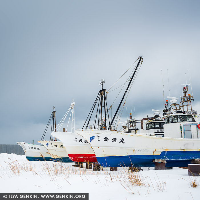
Wakkanai's Fishing Boats in Winter, Hokkaido, Japan.
Fishing boats in Wakkanai, located on the northern tip of Hokkaido, Japan, often spend winter on the shore due to the harsh and icy conditions in the Sea of Japan and the Sea of Okhotsk during this season. Winters in Wakkanai bring extremely cold temperatures, heavy snow, and powerful winds that make fishing difficult and sometimes impossible. Additionally, the coastal waters can develop ice floes that create hazardous conditions for small to medium-sized fishing boats. Most fishing activity in Wakkanai centres around summer and fall, with key catches like sea urchins, salmon, and crabs, which are abundant in warmer months. Winter provides a natural pause for maintenance and repair on these boats, giving fishermen the time needed to work on engines, hulls, and fishing gear. In some cases, the boats are pulled ashore or placed in dry docks to protect them from rough seas and freezing waters, ensuring they are ready for the next active fishing season. The snowy winter landscape surrounding the boats at rest has become a familiar sight in Wakkanai, and for some, it's even a point of local beauty and charm, capturing a peaceful period in the local fishing cycle.

Hargraves Lookout and Megalong Valley at Sunset, Blackheath, Blue Mountains National Park, NSW, Australia 2 Nov 2024 7:15 PM (5 months ago)
Hargraves Lookout and Megalong Valley at Sunset, Blackheath, Blue Mountains National Park, NSW, Australia.
Panoramic view of Megalong Valley at sunset. The landscape glows with the warm colours of the setting sun. Seen from Hargraves Lookout, the rugged cliffs, vast valleys, and distant mountain ranges stretch out in all directions, painted in shades of green, gold, and ochre. The Red Gums and towering Mountain Ashes stand tall, their trunks and leaves illuminated with a rich, reddish hue in the golden light. As the sun dips lower, the sky becomes a canvas of pink, orange, and deep purple, casting a serene and timeless atmosphere over this secluded Australian wilderness.

Public Library of New South Wales, Sydney, NSW, Australia 2 Nov 2024 3:19 PM (5 months ago)
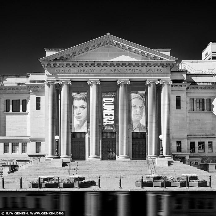
Public Library of New South Wales, Sydney, NSW, Australia.
In this black-and-white photograph, the Mitchell Building of the State Library of New South Wales stands as a testament to classical architecture and craftsmanship. The heritage-listed structure exudes grandeur, with its sandstone facade glowing softly in the monochromatic tones. Tall Ionic columns line the entrance, their fluted shafts and intricate capitals carved with precision, grounding the building with a sense of classical authority. Above the entrance, decorative stonework and sculpted pediments are highlighted in subtle contrasts, showcasing an eye for detail that speaks to an era of meticulous masonry. Large arched windows punctuate the facade, their frames creating rhythmic shadows that add depth and symmetry. The building's crowning balustrade, adorned with elegant urns and stone detailing, completes the composition, capturing a balance between strength and refinement. The photo conveys not only the architectural beauty of the Mitchell Building but also its timeless role as a cultural institution nestled in the heart of Sydney. In 1975 the Public Library of New South Wales it became the State Library of New South Wales.

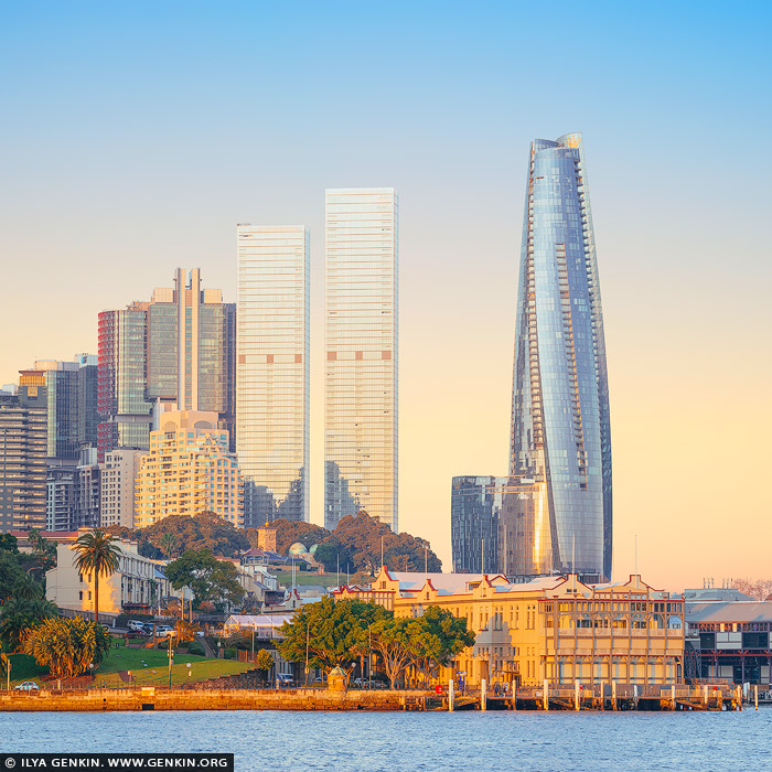
Aurora Place and Chifley Tower, Sydney, NSW, Australia 2 Nov 2024 3:18 PM (5 months ago)
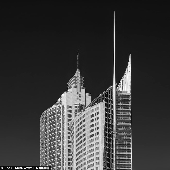
Aurora Place and Chifley Tower, Sydney, NSW, Australia.
In this black-and-white photograph, Aurora Place and Chifley Tower rise prominently against Sydney's sky, captured in striking detail. Aurora Place, with its curved, sail-like facade, reflects light in varying shades of grey, giving the building a fluid, almost organic presence against the static background. The glass curtain walls of Aurora Place arc gently, with a delicate texture that contrasts its modern, angular neighbouring structures. Beside it stands Chifley Tower, its sleek, stepped design and clean vertical lines embodying the late 20th-century corporate aesthetic. Chifley's smooth concrete and glass surfaces appear slightly darker, grounding it in a timeless, monolithic elegance. The juxtaposition of the two buildings - the organic flow of Aurora Place and the geometric precision of Chifley Tower - illustrates the contrasting architectural philosophies of Sydney's evolving skyline, blending bold modernism with subtle gestures of nature-inspired design.

The Astor and Chief Secretary's Building, Sydney, NSW, Australia 2 Nov 2024 3:18 PM (5 months ago)
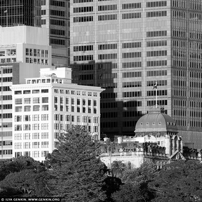
The Astor and Chief Secretary's Building, Sydney, NSW, Australia.
In this black-and-white photograph, the heritage-listed Chief Secretary's Building, originally and still commonly known as the Colonial Secretary's Building, and The Astor, one of Sydney's most distinguished residential buildings, create a captivating contrast against the modern high-rises of Sydney's evolving skyline. The Chief Secretary's Building stands as a masterpiece of Victorian Free Classical architecture, its richly ornamented facade adorned with detailed pilasters, archways, and a clock tower crowned with a delicate dome. The intricate stonework and classical proportions exude a dignified charm, evoking Sydney's colonial history. Nearby, The Astor — a distinguished residential building in the Interwar Free Classical style — rises with its solid brick and sandstone facade, boasting tall, arched windows and restrained, elegant detailing that emphasise its enduring sophistication. These historic structures are juxtaposed against sleek, contemporary skyscrapers that loom above them, their minimalist glass and steel facades reflecting light in sharp, angular patterns. This striking composition of old and new highlights Sydney's layered architectural identity, where heritage buildings like the Chief Secretary's Building and The Astor retain their presence and dignity amidst the city's continual growth and transformation. The photo captures an architectural dialogue between the historic and the modern, reminding viewers of Sydney's respect for both legacy and innovation.

Ebisu Iwa and Daikoku Rock, Yoichi, Hokkaido, Japan 11 Oct 2024 5:06 PM (6 months ago)
Ebisu Iwa and Daikoku Rock, Yoichi, Hokkaido, Japan.
Ebisu Iwa and Daikoku Rock are two iconic rock formations located off the coast of Yoichi, a town on the western coast of Hokkaido, Japan. They are revered for their striking natural beauty and cultural significance, often serving as symbols of the rugged coastal scenery of this region. The two rocks together embody the dual blessings of good fortune, wealth, and safe seas. In the past, these formations may have been focal points for rituals and prayers by local fishermen, who relied on divine protection for bountiful catches and safe returns from the treacherous northern seas. The coast of Yoichi, where Ebisu Iwa and Daikoku Iwa are found, is renowned for its rugged beauty, with dramatic cliffs, crashing waves, and a wide view of the Sea of Japan. Visitors often stop at a viewing area on the mainland to admire these two striking formations, especially during sunset when the rocks are silhouetted against the vibrant sky. These rock formations are not just geological marvels but also cultural landmarks that represent both the natural beauty and the deep spiritual heritage of Yoichi and its maritime history.

Thirty Eight Birches at Sunrise, Seven Star Tree, Biei, Hokkaido, Japan 6 Oct 2024 7:00 PM (6 months ago)
Thirty Eight Birches at Sunrise, Seven Star Tree, Biei, Hokkaido, Japan.
The photo captures a serene early winter morning near Biei, Hokkaido, where thirty-eight slender birch trees stand in a perfect row, their white trunks glowing with a soft red hue as the rising sun bathes them in warm light. The snow beneath the trees is freshly fallen, pristine and untouched, creating a crisp contrast to the vivid blue sky above. The air seems crisp and clean, as if carrying the pure essence of winter. The clear sky, devoid of clouds, adds to the calm and peaceful atmosphere, framing the striking birches against a backdrop of natural beauty.

Sydney Opera House Sails at Sunrise, Sydney, NSW, Australia 28 Sep 2024 10:33 PM (6 months ago)
Sydney Opera House Sails at Sunrise, Sydney, NSW, Australia.
The Sydney Opera House is renowned for its striking sail-like shells, which are emblematic of its innovative design and architectural brilliance. These shells, constructed from a series of precast concrete panels, evoke the image of billowing sails catching the wind, symbolising both movement and fluidity. Arranged in a graceful formation, the shells create a sense of harmony with their surroundings, while their gleaming white surface reflects the changing light throughout the day. This iconic feature not only enhances the visual impact of the structure but also serves as a testament to the vision of architect Jorn Utzon, who sought to merge the building with the natural beauty of Sydney Harbour, making it a masterpiece of modern architecture. The photo showcases the iconic Sydney Opera House, bathed in the warm, golden light of sunrise. Its distinctive sail-like shells glow against the soft pastel colours of the morning sky, creating a striking contrast with the calm waters of Sydney Harbour. The sun's rays gently illuminate the building's unique architecture, emphasising its graceful curves and lines. This enchanting moment captures the beauty and elegance of one of the world's most recognisable landmarks, inviting viewers to experience the serenity and majesty of this iconic location.

Dryridge Estate Winery and Megalong Valley at Sunset, Blue Mountains National Park, NSW, Australia 28 Sep 2024 10:12 PM (6 months ago)
Dryridge Estate Winery and Megalong Valley at Sunset, Blue Mountains National Park, NSW, Australia.
The photo captures the breathtaking landscape of Dryridge Estate Winery, where lush vineyards stretch gracefully in the foreground. Rows of grapevines, heavy with ripening fruit, create a vibrant green carpet that leads the eye toward the majestic Megalong Valley. In the background, the dramatic cliffs rise sharply against the sky, their rugged features illuminated by the warm, golden hues of the setting sun. The light casts a soft glow over the entire scene, enhancing the rich colours of the vines and the stunning natural beauty of the valley, making it a picturesque snapshot of tranquility and abundance in the heart of wine country.

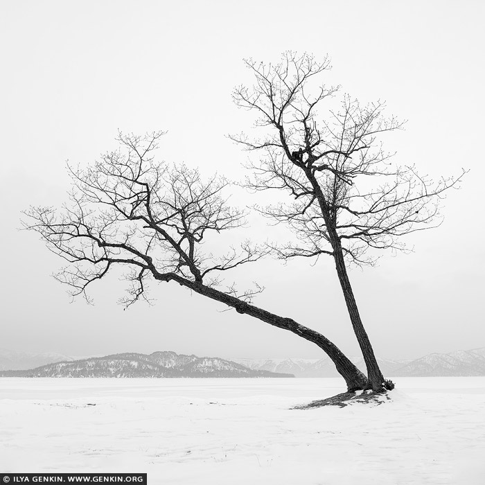
Kussharo Lake Tree, Study 2, Kussharo Lake, Teshikaga, Hokkaido, Japan 28 Sep 2024 9:51 PM (6 months ago)
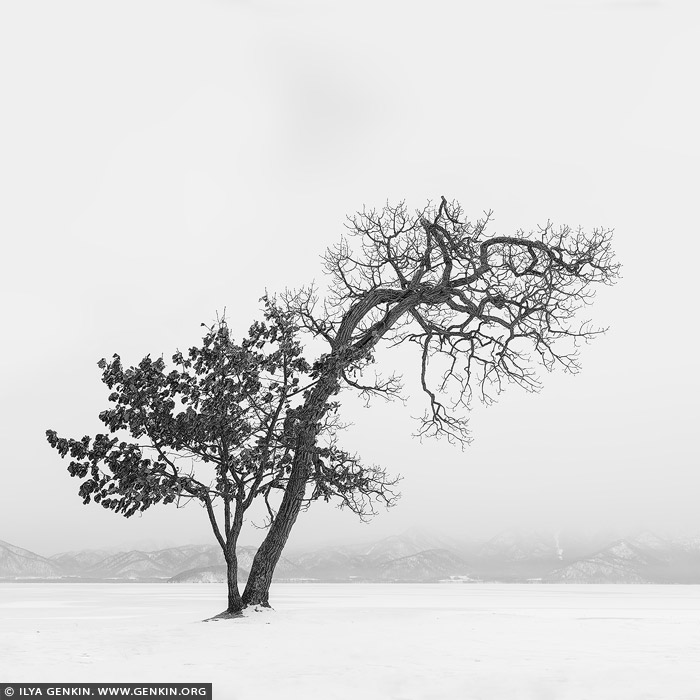
Kussharo Lake Tree, Study 2, Kussharo Lake, Teshikaga, Hokkaido, Japan.
Another black-and-white minimalistic photo captures the solitary figure of a tree standing on the snow-covered shore of Lake Kussharo on Hokkaido. The tree, almost stripped of leaves, is rendered as a stark silhouette against the bright, white sky, its delicate, bare branches reaching upward in graceful patterns. The snow blankets the ground and the frozen lake in a seamless, smooth layer, creating a soft, uninterrupted surface that stretches to the horizon. The sky and the snow merge into a single expanse of light, making the dark outline of the tree the sole focal point of the image. Its intricate branches, etched against the pale backdrop, convey both fragility and resilience in the harsh winter landscape. The absence of detail in the surroundings enhances the feeling of isolation, as if the world has been reduced to this singular, quiet moment on the lake's shore. The minimalism of the scene emphasises the beauty in simplicity - the tree's silhouette stands as a symbol of endurance amid the vast, snowy silence of Lake Kussharo. The photograph evokes a sense of calm, timelessness, and serene solitude in the frozen winter wilderness of Hokkaido.

Ebisu Iwa. Study 1, Yoichi, Hokkaido, Japan 28 Sep 2024 9:50 PM (6 months ago)
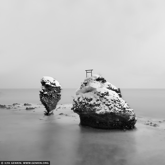
Ebisu Iwa. Study 1, Yoichi, Hokkaido, Japan.
A long exposure black-and-white photograph captures the serene beauty of Ebisu Iwa and Daikoku Rock off the rugged coast of Yoichi, Hokkaido. The stark contrast between the dark, jagged rock formations and the smooth, misty surface of the sea creates a hauntingly tranquil scene. The extended exposure blurs the motion of the ocean, turning the waves into a silky, ethereal fog that wraps around the ancient rocks like a soft veil. Above, the sky is rendered in subtle grey tones, adding depth and mood to the composition. The monochrome palette emphasises the textures of the weathered stone and the gentle movement of the water, evoking a timeless, almost otherworldly atmosphere. The scene feels isolated yet majestic, a quiet testament to nature's enduring strength and beauty.

Greenhouse Structure, Study 1, Biei, Hokkaido, Japan 28 Sep 2024 9:48 PM (6 months ago)
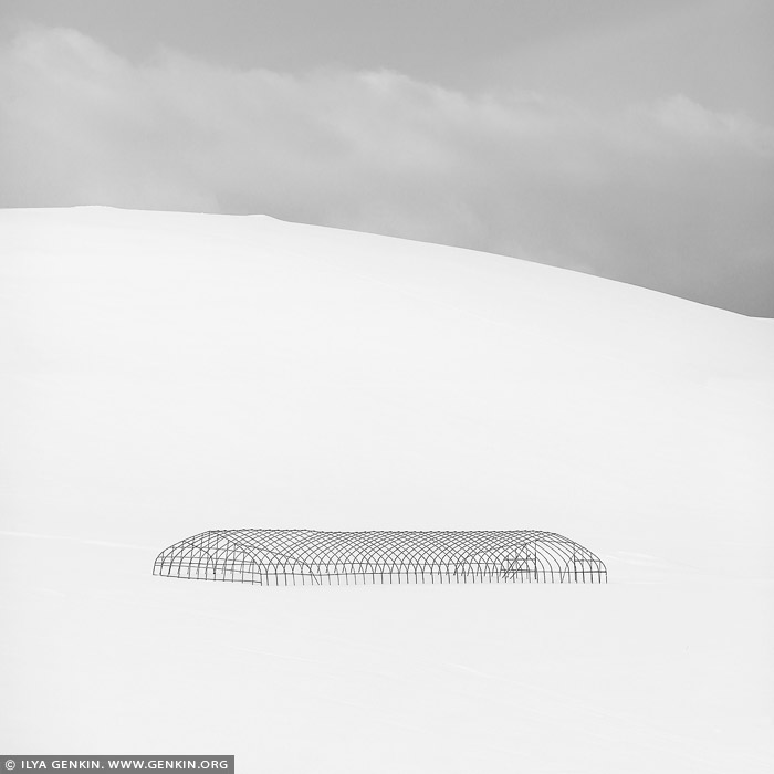
Greenhouse Structure, Study 1, Biei, Hokkaido, Japan.
A black-and-white minimalistic photograph captures the stark silhouette of a greenhouse structure standing alone on a snow-covered slope. The clean lines of the greenhouse frame are sharply defined against the pale, featureless expanse of snow, creating a striking contrast between the dark, angular form of the building and the soft, flowing contours of the snowy landscape. The slope of the hill, blanketed in smooth, untouched snow, adds a gentle curve to the composition, while the sky, nearly blending into the whiteness of the ground, remains an empty, bright backdrop. The minimalist nature of the image strips away distractions, leaving only the bold, geometric shape of the greenhouse, isolated and quiet in the vast winter landscape. The silhouette, devoid of detail, is almost abstract, standing in sharp relief against the blank canvas of snow and sky. The scene evokes a sense of stillness and solitude, as if the world outside the frame has disappeared, leaving only the greenhouse and the serene, endless snow. The simplicity of the image highlights both the structure's fragility and its presence in the vast emptiness, creating a contemplative and peaceful atmosphere.

Forest Edge. Study 2, Biei, Hokkaido, Japan 28 Sep 2024 9:47 PM (6 months ago)
Forest Edge. Study 2, Biei, Hokkaido, Japan.
A black-and-white photograph portrays the serene beauty of a small pine tree grove perched on a snow-covered hill in winter near Biei, Hokkaido. The pines, standing tall and dark, create a striking contrast against the pristine, untouched snow that blankets the hillside. Their branches, lightly dusted with snow, form delicate silhouettes, sharply defined against the bright, white landscape. The gentle curve of the hill adds a sense of subtle movement, while the snow appears smooth and immaculate, softening the scene and drawing attention to the starkness of the trees. The sky, pale and almost indistinguishable from the ground, enhances the quiet isolation of the grove, blurring the boundaries between earth and sky. The absence of detail in the sky and snow highlights the minimalist beauty of the winter landscape, focusing the viewer's attention on the grove's simplicity and grace.

Thirty Eight Birches. Study 1, Seven Star Tree, Biei, Hokkaido, Japan 28 Sep 2024 9:47 PM (6 months ago)
Thirty Eight Birches. Study 1, Seven Star Tree, Biei, Hokkaido, Japan.
In this black-and-white photograph, the silhouettes of birch trees stand starkly against a bright, luminous sky near the famous Seven Stars Tree in Biei, Hokkaido. The trees form a graceful line, their slender trunks and delicate branches reduced to dark, almost ghostly shapes. The absence of color enhances their silhouette, creating a striking contrast between the inky blackness of the birches and the pale, glowing expanse of the sky. The photo evokes a sense of quiet isolation and minimalism, with the trees appearing both fragile and resilient, standing in quiet defiance of the vast, open space around them. The scene is haunting yet serene, capturing a fleeting moment of stark beauty in Hokkaido's expansive landscape.

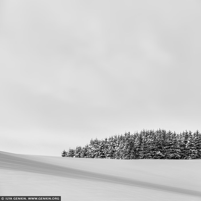
Forest Edge. Study 1, Biei, Hokkaido, Japan 28 Sep 2024 9:46 PM (6 months ago)
Forest Edge. Study 1, Biei, Hokkaido, Japan.
A black-and-white photograph captures the quiet solitude of a small pine tree grove on a snow-covered hill in winter near Biei, Hokkaido. The trees, dark and delicate, stand in sharp contrast to the smooth, unbroken expanse of snow that blankets the hill, creating a serene and minimalist composition. Each pine, with its branches dusted in snow, appears as a delicate silhouette against the bright, white background, their forms etched in soft shadow. The gentle slope of the hill adds a sense of calm motion, while the snow itself is rendered as a smooth, almost ethereal surface, devoid of texture except where the trees meet the ground. The sky above, a pale, featureless expanse, merges with the snow, enhancing the feeling of isolation and tranquility. The monochrome palette emphasises the stark beauty of winter, where the simplicity of nature is laid bare - just the trees, the snow, and the quiet, endless sky. The scene evokes a sense of stillness and peace, as if time has momentarily paused in the frozen landscape of Hokkaido.

Hilltop Trees, Study 1, Teshikaga, Hokkaido, Japan 28 Sep 2024 9:42 PM (6 months ago)
Hilltop Trees, Study 1, Teshikaga, Hokkaido, Japan.
A black-and-white minimalistic photograph showcases a small grove of trees perched atop a gently rolling hill, where the landscape is nearly blanketed in snow. The trees against the light background, create a striking contrast, their forms standing in sharp relief against the pale, snowy slope below. The hill itself, softly rounded and almost entirely covered in pristine snow, curves gently beneath the trees, creating a serene flow to the image. The texture of the snow is subdued, rendering it a smooth, soft surface that amplifies the minimalist aesthetic. The sky above, bright and almost featureless, merges seamlessly with the snowy ground, enhancing the feeling of openness and tranquility. This simplicity allows the viewer to focus on the grove, isolated yet resilient, standing boldly against the vastness of the winter landscape. The overall effect evokes a sense of peace and solitude, capturing a quiet moment in nature where the beauty lies in the stark contrasts and the stillness of the scene.

Sydney City at Dawn, Sydney, New South Wales (NSW), Australia 4 Sep 2024 5:23 PM (7 months ago)
Sydney City at Dawn, Sydney, New South Wales (NSW), Australia.
The photo captures a stunning view of Circular Quay and Sydney City at sunrise, taken from across the harbor. The entire cityscape is bathed in a warm, golden light, which highlights the modern skyline's diverse mix of skyscrapers and historic buildings. The sunlight reflects off the glass facades, casting a soft, amber glow that enhances the architectural details of each structure. Circular Quay, bustling with ferries and boats, is nestled along the water's edge, its iconic wharves shimmering under the sunrise's brilliance. The calm harbor waters mirror the glowing city, creating a breathtaking display of light and color. In the background, the fading sky is a blend of deep oranges, pinks, and purples, adding a sense of drama and serenity to the scene.
,%20Australia%26bodytext%3D%3Ca%20href%3D%22https://www.genkin.org/cgi-bin/photo.pl/australia/sydney/city/au-sydney-0034%22%20title%3D%22Sydney%20City%20at%20Dawn,%20Sydney,%20New%20South%20Wales%20(NSW),%20Australia%22%3E%3Cimg%20src%3D%22https://www.genkin.org/gallery/australia/sydney/city/au-sydney-0034.jpg%22%20alt%3D%22australia%20stock%20photography%20%7C%20Sydney%20City%20at%20Dawn,%20Sydney,%20New%20South%20Wales%20(NSW),%20Australia.%20The%20photo%20captures%20a%20stunning%20view%20of%20Circular%20Quay%20and%20Sydney%20City%20at%20sunrise,%20taken%20from%20across%20the%20harbor.%20The%20entire%20cityscape%20is%20bathed%20in%20a%20warm,%20golden%20light,%20which%20highlights%20the%20modern%20skyline's%20diverse%20mix%20of%20skyscrapers%20and%20historic%20buildings.%20The%20sunlight%20reflects%20off%20the%20glass%20facades,%20casting%20a%20soft,%20amber%20glow%20that%20enhances%20the%20architectural%20details%20of%20each%20structure.%20Circular%20Quay,%20bustling%20with%20ferries%20and%20boats,%20is%20nestled%20along%20the%20water's%20edge,%20its%20iconic%20wharves%20shimmering%20under%20the%20sunrise's%20brilliance.%20The%20calm%20harbor%20waters%20mirror%20the%20glowing%20city,%20creating%20a%20breathtaking%20display%20of%20light%20and%20color.%20In%20the%20background,%20the%20fading%20sky%20is%20a%20blend%20of%20deep%20oranges,%20pinks,%20and%20purples,%20adding%20a%20sense%20of%20drama%20and%20serenity%20to%20the%20scene.%22%20/%3E%3C/a%3E%3Cbr%20/%3E%3Cb%3ESydney%20City%20at%20Dawn,%20Sydney,%20New%20South%20Wales%20(NSW),%20Australia%3C/b%3E.%3Cbr%20/%3EThe%20photo%20captures%20a%20stunning%20view%20of%20Circular%20Quay%20and%20Sydney%20City%20at%20sunrise,%20taken%20from%20across%20the%20harbor.%20The%20entire%20cityscape%20is%20bathed%20in%20a%20warm,%20golden%20light,%20which%20highlights%20the%20modern%20skyline's%20diverse%20mix%20of%20skyscrapers%20and%20historic%20buildings.%20The%20sunlight%20reflects%20off%20the%20glass%20facades,%20casting%20a%20soft,%20amber%20glow%20that%20enhances%20the%20architectural%20details%20of%20each%20structure.%20Circular%20Quay,%20bustling%20with%20ferries%20and%20boats,%20is%20nestled%20along%20the%20water's%20edge,%20its%20iconic%20wharves%20shimmering%20under%20the%20sunrise's%20brilliance.%20The%20calm%20harbor%20waters%20mirror%20the%20glowing%20city,%20creating%20a%20breathtaking%20display%20of%20light%20and%20color.%20In%20the%20background,%20the%20fading%20sky%20is%20a%20blend%20of%20deep%20oranges,%20pinks,%20and%20purples,%20adding%20a%20sense%20of%20drama%20and%20serenity%20to%20the%20scene.)
Sydney Harbour Bridge Silhouette, Sydney, New South Wales, Australia 4 Sep 2024 5:04 PM (7 months ago)
Sydney Harbour Bridge Silhouette, Sydney, New South Wales, Australia.
The photo showcases the silhouette of the Sydney Harbour Bridge's steel arches in the evening light. The intricate latticework of beams and girders is sharply defined against the sky, which fades from blue at the top to warm shades of yellow near the horizon as the sun sets. The bridge's massive, sweeping arches create a bold, striking contrast against this vibrant backdrop. The scene exudes a sense of calm and grandeur as day transitions into night.

Sydney Opera House at Sunrise, Kirribilli, Sydney, New South Wales (NSW), Australia 17 Aug 2024 7:39 PM (8 months ago)
Sydney Opera House at Sunrise, Kirribilli, Sydney, New South Wales (NSW), Australia.
The Sydney Opera House stands majestically against a brilliant sunrise, bathed in a warm, golden light. The iconic sails of the building glow softly as the first rays of the day touch the harbour, casting a serene reflection on the water below. The vibrant sky hues blend seamlessly with the elegant curves of the Opera House, creating a captivating harmony of nature and architecture as Sydney awakens.
,%20Australia%26bodytext%3D%3Ca%20href%3D%22https://www.genkin.org/cgi-bin/photo.pl/australia/sydney/soh/au-sydney-opera-house-0047%22%20title%3D%22Sydney%20Opera%20House%20at%20Sunrise,%20Kirribilli,%20Sydney,%20New%20South%20Wales%20(NSW),%20Australia%22%3E%3Cimg%20src%3D%22https://www.genkin.org/gallery/australia/sydney/soh/au-sydney-opera-house-0047.jpg%22%20alt%3D%22australia%20stock%20photography%20%7C%20Sydney%20Opera%20House%20at%20Sunrise,%20Kirribilli,%20Sydney,%20New%20South%20Wales%20(NSW),%20Australia.%20The%20Sydney%20Opera%20House%20stands%20majestically%20against%20a%20brilliant%20sunrise,%20bathed%20in%20a%20warm,%20golden%20light.%20The%20iconic%20sails%20of%20the%20building%20glow%20softly%20as%20the%20first%20rays%20of%20the%20day%20touch%20the%20harbour,%20casting%20a%20serene%20reflection%20on%20the%20water%20below.%20The%20vibrant%20sky%20hues%20blend%20seamlessly%20with%20the%20elegant%20curves%20of%20the%20Opera%20House,%20creating%20a%20captivating%20harmony%20of%20nature%20and%20architecture%20as%20Sydney%20awakens.%22%20/%3E%3C/a%3E%3Cbr%20/%3E%3Cb%3ESydney%20Opera%20House%20at%20Sunrise,%20Kirribilli,%20Sydney,%20New%20South%20Wales%20(NSW),%20Australia%3C/b%3E.%3Cbr%20/%3EThe%20Sydney%20Opera%20House%20stands%20majestically%20against%20a%20brilliant%20sunrise,%20bathed%20in%20a%20warm,%20golden%20light.%20The%20iconic%20sails%20of%20the%20building%20glow%20softly%20as%20the%20first%20rays%20of%20the%20day%20touch%20the%20harbour,%20casting%20a%20serene%20reflection%20on%20the%20water%20below.%20The%20vibrant%20sky%20hues%20blend%20seamlessly%20with%20the%20elegant%20curves%20of%20the%20Opera%20House,%20creating%20a%20captivating%20harmony%20of%20nature%20and%20architecture%20as%20Sydney%20awakens.)
Bright Sunrise over Millers Point and Barangaroo, Sydney, New South Wales, Australia 17 Aug 2024 7:38 PM (8 months ago)
Bright Sunrise over Millers Point and Barangaroo, Sydney, New South Wales, Australia.
Sunrise over Sydney paints a breathtaking scene, with the warm glow illuminating Millers Point, skyscrapers in Barangaroo, and the Crown Casino. The early light casts a golden hue across the bustling harbour, highlighting the sleek skyline and tranquil waters in a perfect start to the day. The city wakes up in vibrant hues, reflecting off the shimmering waves and casting long shadows that dance across the waterfront. It's a stunning reminder of Sydney's unique charm and beauty.

Berowra Waters Lookout, Berowra Valley National Park, Hornsby Shire, NSW, Australia 20 Apr 2024 5:45 PM (12 months ago)
Berowra Waters Lookout, Berowra Valley National Park, Hornsby Shire, NSW, Australia.
Berowra Waters is among Hornsby Shire's most beautiful (and hidden away) areas, perfect for anyone who wants to escape the rush of everyday life. Surrounded by stunning Berowra Valley National Park, the region has beautiful natural scenery to enjoy, a range of bush walks, great spots to go fishing and many other attractions such as great restaurants and cafe. It was thought that Berowra was an Aboriginal word that means place of many winds. However, it actually means 'place of many shells' referring to the many shell middens on Berowra Creek. It was once a residence for Australian actress Cate Blanchett and her husband Andrew Upton.
%20areas,%20perfect%20for%20anyone%20who%20wants%20to%20escape%20the%20rush%20of%20everyday%20life.%20Surrounded%20by%20stunning%20Berowra%20Valley%20National%20Park,%20the%20region%20has%20beautiful%20natural%20scenery%20to%20enjoy,%20a%20range%20of%20bush%20walks,%20great%20spots%20to%20go%20fishing%20and%20many%20other%20attractions%20such%20as%20great%20restaurants%20and%20cafe.%20It%20was%20thought%20that%20Berowra%20was%20an%20Aboriginal%20word%20that%20means%20place%20of%20many%20winds.%20However,%20it%20actually%20means%20'place%20of%20many%20shells'%20referring%20to%20the%20many%20shell%20middens%20on%20Berowra%20Creek.%20It%20was%20once%20a%20residence%20for%20Australian%20actress%20Cate%20Blanchett%20and%20her%20husband%20Andrew%20Upton.%22%20/%3E%3C/a%3E%0A%3Cbr%20/%3E%0A%3Cb%3EBerowra%20Waters%20Lookout,%20Berowra%20Valley%20National%20Park,%20Hornsby%20Shire,%20NSW,%20Australia%3C/b%3E.%0A%3Cbr%20/%3EBerowra%20Waters%20is%20among%20Hornsby%20Shire's%20most%20beautiful%20(and%20hidden%20away)%20areas,%20perfect%20for%20anyone%20who%20wants%20to%20escape%20the%20rush%20of%20everyday%20life.%20Surrounded%20by%20stunning%20Berowra%20Valley%20National%20Park,%20the%20region%20has%20beautiful%20natural%20scenery%20to%20enjoy,%20a%20range%20of%20bush%20walks,%20great%20spots%20to%20go%20fishing%20and%20many%20other%20attractions%20such%20as%20great%20restaurants%20and%20cafe.%20It%20was%20thought%20that%20Berowra%20was%20an%20Aboriginal%20word%20that%20means%20place%20of%20many%20winds.%20However,%20it%20actually%20means%20'place%20of%20many%20shells'%20referring%20to%20the%20many%20shell%20middens%20on%20Berowra%20Creek.%20It%20was%20once%20a%20residence%20for%20Australian%20actress%20Cate%20Blanchett%20and%20her%20husband%20Andrew%20Upton.%3C/p%3E)
Kussharo Lake Tree, Study 1, Kussharo Lake, Teshikaga, Hokkaido, Japan 24 Feb 2024 8:47 PM (last year)
Kussharo Lake Tree, Study 1, Kussharo Lake, Teshikaga, Hokkaido, Japan.
The shore of the Kussharo Lake on Hokkaido became famous after Michael Kenna photographed a Japanese Oak in 2002 which reminded him a kanji character. Since then thousands photographers coming each year to Kussharo Lake to photograph dancing trees on the banks of Kussharo Lake. The original tree does not exist now, but people are still visiting the lake.

Christmas Tree. Study 1, Biei, Hokkaido, Japan 24 Feb 2024 8:47 PM (last year)
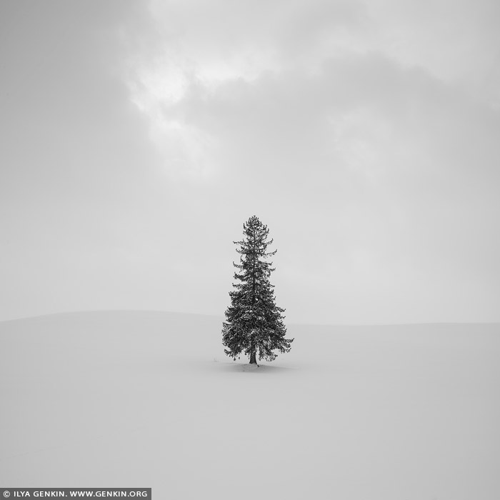
Christmas Tree. Study 1, Biei, Hokkaido, Japan.
Biei in Hokkaido, Japan is home to an abundance of photogenic spots, including the famous Blue Pond and Shikisai-no-Oka. The 'Christmas tree' of Biei is probably the most famous and photographed tree of Japan. This single Tohi spruce tree stands along Panorama Road in the southeastern part of Biei. The reason why this particular tree has become known as the Christmas Tree is simple - not only does its shape look like a Christmas tree, but the foliage at the top of the tree also appears like a star. Tohi spruce trees are a type of the hardy Ezomatsu spruce tree and thus don't shed their leaves during winter. In winter this lone tree stands dignified among the snowy landscape, with its shadow beautiful extending along the ground. Lots of people flock here in pursuit of capturing this beautiful scene on camera. It is also very magical to see the tree amongst the falling snow! It's difficult to get an idea of how crowded this area actually is just by looking at this peaceful image. Luckily this is a private property which means no one can walk in and ruin the amazing field of snow around it.

Torii Gate of the Toyosaki Konpira Shrine, Shosanbetsu, Hokkaido, Japan 24 Feb 2024 8:46 PM (last year)
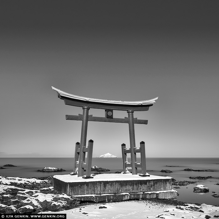
Torii Gate of the Toyosaki Konpira Shrine, Shosanbetsu, Hokkaido, Japan.
The village of Shosanbetsu is located along a stretch of the Sea of Japan's coast. Running south to north, the Ororon Line transports people through the area. With the beautiful coast on one side, it is easy to see why droves of photographers have been making their way to Shosanbetsu. Especially popular is the red torii gates of the Toyosaki Konpira Shrine that stand alone and vibrantly off the coast of Cape Konpira. Why not visit this spot and try your hand at capturing the striking red structure contrasted against the beautiful blue sky and ocean? Or, maybe you are more of a romantic and would prefer shooting the setting sun glowing through the gate? Night owls might want to come out on a starry night and watch the torii be enveloped by the cosmos. Whatever your preference, the Toyosaki Konpira Shrine gates will not disappoint!

Fishing Boats in Winter at Wakkanai, Hokkaido, Japan 24 Feb 2024 8:45 PM (last year)
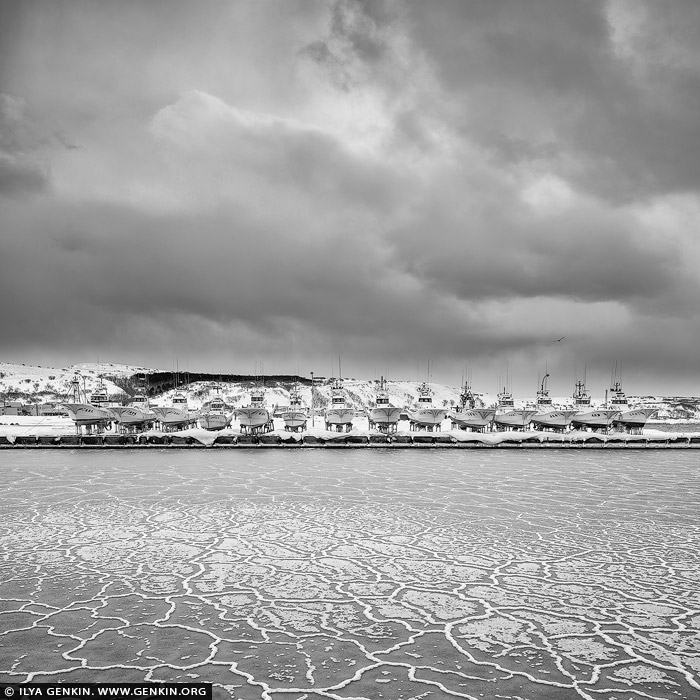
Fishing Boats in Winter at Wakkanai, Hokkaido, Japan.
Stormy day on the northernmost part of Hokkaido, Japan. Fishing boats waiting for spring at Wakkanai Fishing Port.

Bunyeroo Valley and Razorback Lookout at Sunset, Flinders Ranges, SA, Australia 6 Jan 2024 1:27 AM (last year)
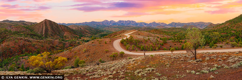
Bunyeroo Valley and Razorback Lookout at Sunset, Flinders Ranges, SA, Australia.
When driving along the scenic Bunyeroo Valley road in the Flinders Ranges, SA, Australia, stop at the Razorback lookout. The views over the valley to the surrounding ranges are gorgeous. The valley and the Razorback are absolutely magnificent at sunrise or sunset.

Milky Way Raising over Heart of Country, Sculpture Down the Lachlan, Lachlan Valley Way, Condobolin, NSW, Australia 19 Sep 2023 1:32 AM (last year)
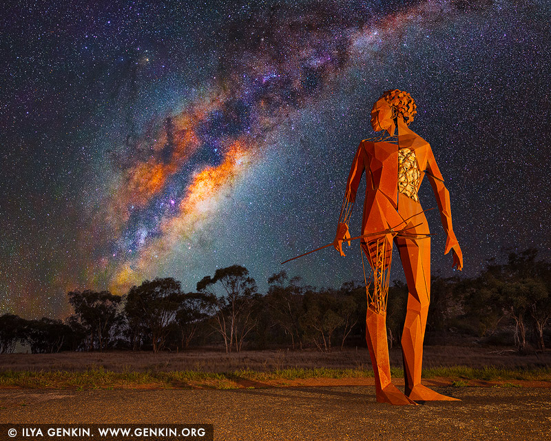
Milky Way Raising over Heart of Country, Sculpture Down the Lachlan, Lachlan Valley Way, Condobolin, NSW, Australia.
Sculpture Down the Lachlan is the newest tourist attraction in the Central West of NSW. The 100-kilometre arts trail starts in Forbes and follows the Lachlan River along the Lachlan Valley Way to Condobolin. But Sculpture Down the Lachlan isn't your ordinary public art trail - think Sculptures by the Sea... but in the bush. Art embedded in nature. Designed to showcase the raw, unmanicured beauty of the rural landscape in which envelops the larger-than-life installations. Featuring over twenty sculptures by some of Australia's leading creatives. The most prominent is the Heart of Country by Damian Vick. He stands proudly at six metres tall. His bold stance and keen focus cut a potent and deadly impression whilst making the inescapable suggestion that he is searching for something unseen, lost along the way, relegated to the past. The one-tonne Corten Steel sculpture explores the notions of strength, vulnerability and connection. 'Heart of Country' is an attempt to acknowledge the injustices endured by the Wiradjuri people whilst also standing as a testament to the collective resilience and determination of all indigenous Australians and their profound spiritual connection with the land.

Cipressi di San Quirico d'Orcia, Val d'Orcia, Tuscany, Italy 2 Sep 2023 10:58 PM (last year)
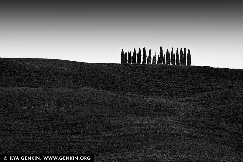
Cipressi di San Quirico d'Orcia, Val d'Orcia, Tuscany, Italy.
Among the places most loved by photographers in the Val d'Orcia there is certainly the cypress grove on the hills of San Quirico d'Orcia. The cypress, present throughout the area, is a very ancient plant which owes its name to the myth of the young Cyparissus loved by the god Apollo. Its presence in Tuscany dates back to several centuries before Christ when it was imported from Asia Minor and was particularly loved by the Etruscans up to the Renaissance painters who immortalised it in unforgettable works. This sort of veneration handed down over the centuries has led the cypress to become a characteristic element of the streets, property boundaries, farms and hills of the Val d'Orcia. The group of cypresses, suggestive and emblematic, in the midst of the bare hills of San Quirico d'Orcia, has suggested all sorts of legends and rumours even if its history is linked to the hunting 'roccolo', that is, a grove created by hunters to attract birds.

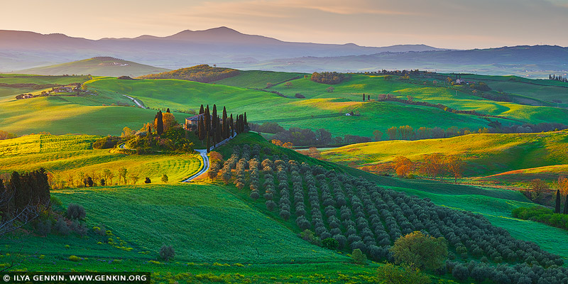
Podere Belvedere at Sunrise, Pienza, Val d'Orcia, Tuscany, Italy 2 Sep 2023 10:57 PM (last year)
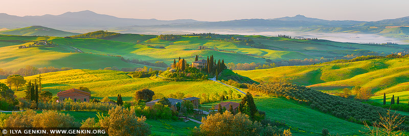
Podere Belvedere at Sunrise, Pienza, Val d'Orcia, Tuscany, Italy.
The Podere Belvedere is actually the name of an old stone farmhouse that is visible in the famous view and so when people talk about going to see the Podere Belvedere, they really mean the view and not just the house. When we talk about going to this spot, we actually mean going to the hills that look over this area in order to include that photogenic old house on a hilltop surrounded by trees and the valley of rolling lush green hills that unfolds below, with a ring of mountains in the distance and, ideally, a foggy blanket covering it all in wisps, completing the whole look.

Cipressi di San Quirico d'Orcia, Val d'Orcia, Tuscany, Italy 2 Sep 2023 10:56 PM (last year)
Cipressi di San Quirico d'Orcia, Val d'Orcia, Tuscany, Italy.
The most popular places amongst photographers of Val d'Orcia certainly include the cypress tree woodland on the hills of San Quirico d'Orcia. The cypress, found throughout the area, is an ancient tree that owes its name to the myth of the god Apollo's beloved young Cyparissus. Its presence in Tuscany dates back to several centuries before Christ when it was imported from Asia Minor and was particularly loved by all from the Etruscans all the way up to the Renaissance painters who immortalised it in unforgettable works. This sort of centuries-old veneration has led the cypress to become a characteristic element of the roads, property borders, farmhouses and hills of the Val d'Orcia. The group of cypresses, enchanting and symbolic, nestled in the naked hills of San Quirico d'Orcia, has inspired all kinds of legends and old wives' tales despite its history actually being linked to the hunting 'hide', a small wood created by hunters to attract birds. This image evokes uncontaminated countryside, ancient traditions, peace and beauty; the trees represent the symbol of nature and landscape, not only of the Val d'Orcia area but also of all of Tuscany in Italy and throughout the world.

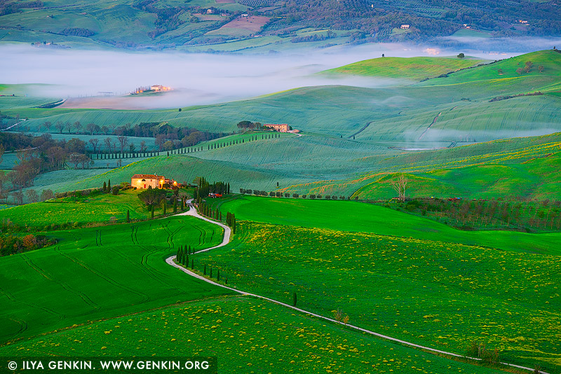
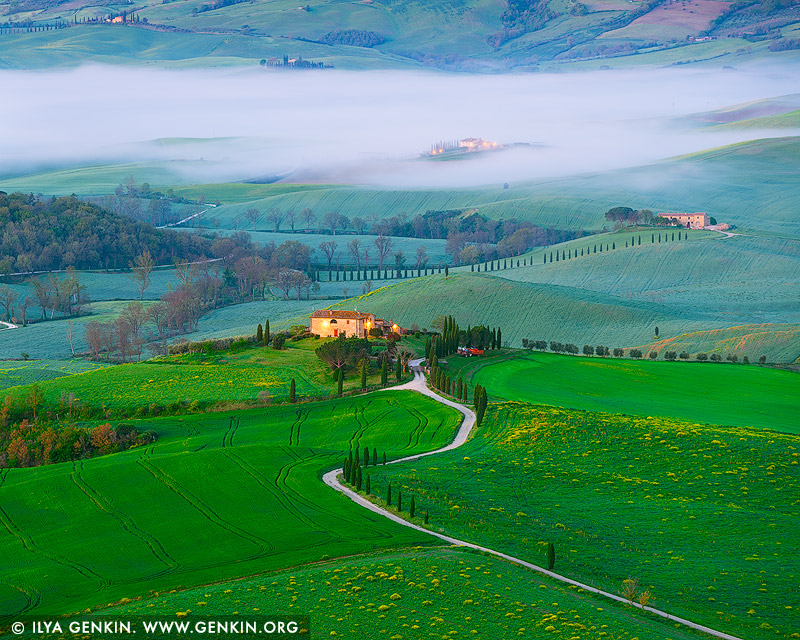
Early Morning at Val d'Orcia near Podere Belvedere, Pienza, Val d'Orcia, Tuscany, Italy 2 Sep 2023 10:55 PM (last year)
Early Morning at Val d'Orcia near Podere Belvedere, Pienza, Val d'Orcia, Tuscany, Italy.
Val d'Orcia is a wide and beautiful countryside in southern Tuscany, close to the border with Umbria and on the slopes of Mount Amiata, stretching along the agricultural hinterland of Siena. It takes its name from the Orcia river that runs along and is a protected park where the absolute protagonist is stunning nature. Medieval castles, sinuous gills, ancient villages, gorgeous farmhouses, isolated homesteads, roads lined with cypress trees, fabulous vineyards and olive groves and golden fields of grain and sunflowers: these are just some of the elements that form the fantastic and harmonious landscapes of the Val d'Orcia. The entire area is protected as a World Heritage Site by UNESCO.

Milky Wave Above ATCA, Australia Telescope Compact Array, Narrabri, NSW, Australia 11 Aug 2023 9:38 PM (last year)
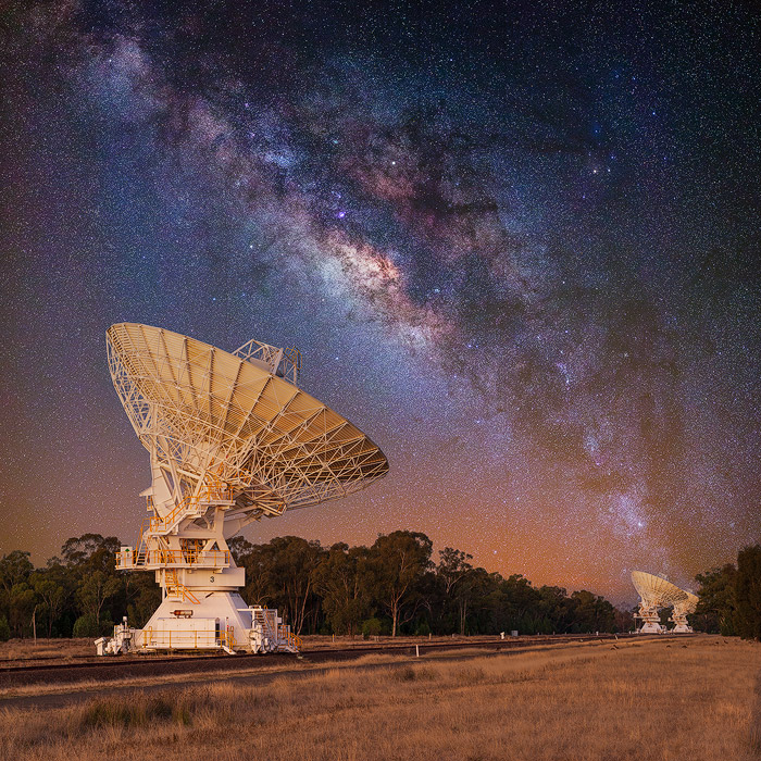
Milky Wave Above ATCA, Australia Telescope Compact Array, Narrabri, NSW, Australia.
The Australia Telescope Compact Array (ATCA), at the Paul Wild Observatory, is an array of six 22-m antennas used for radio astronomy. It is located about 25 km west of the town of Narrabri in rural NSW (about 500 km north-west of Sydney). It is operated by CSIRO's Astronomy and Space Science division, as are the Parkes Observatory and the Mopra Observatory near Coonabarabran. A fourth radio telescope, the Australian Square Kilometre Array Pathfinder, is also being developed by CSIRO at the Murchison Radio-astronomy Observatory in the Mid-West of Western Australia. Collectively, CSIRO's radio astronomy observatories are known as the Australia Telescope National Facility, with the facility supporting Australia's research in radio astronomy.
,%20at%20the%20Paul%20Wild%20Observatory,%20is%20an%20array%20of%20six%2022-m%20antennas%20used%20for%20radio%20astronomy.%20It%20is%20located%20about%2025%20km%20west%20of%20the%20town%20of%20Narrabri%20in%20rural%20NSW%20(about%20500%20km%20north-west%20of%20Sydney).%20It%20is%20operated%20by%20CSIRO's%20Astronomy%20and%20Space%20Science%20division,%20as%20are%20the%20Parkes%20Observatory%20and%20the%20Mopra%20Observatory%20near%20Coonabarabran.%20A%20fourth%20radio%20telescope,%20the%20Australian%20Square%20Kilometre%20Array%20Pathfinder,%20is%20also%20being%20developed%20by%20CSIRO%20at%20the%20Murchison%20Radio-astronomy%20Observatory%20in%20the%20Mid-West%20of%20Western%20Australia.%20Collectively,%20CSIRO's%20radio%20astronomy%20observatories%20are%20known%20as%20the%20Australia%20Telescope%20National%20Facility,%20with%20the%20facility%20supporting%20Australia's%20research%20in%20radio%20astronomy.%22%20/%3E%3C/a%3E%3C/p%3E%0A%0A%3Cp%3E%3Cb%3EMilky%20Wave%20Above%20ATCA,%20Australia%20Telescope%20Compact%20Array,%20Narrabri,%20NSW,%20Australia%3C/b%3E.%3C/p%3E%0A%0A%3Cp%3EThe%20Australia%20Telescope%20Compact%20Array%20(ATCA),%20at%20the%20Paul%20Wild%20Observatory,%20is%20an%20array%20of%20six%2022-m%20antennas%20used%20for%20radio%20astronomy.%20It%20is%20located%20about%2025%20km%20west%20of%20the%20town%20of%20Narrabri%20in%20rural%20NSW%20(about%20500%20km%20north-west%20of%20Sydney).%20It%20is%20operated%20by%20CSIRO's%20Astronomy%20and%20Space%20Science%20division,%20as%20are%20the%20Parkes%20Observatory%20and%20the%20Mopra%20Observatory%20near%20Coonabarabran.%20A%20fourth%20radio%20telescope,%20the%20Australian%20Square%20Kilometre%20Array%20Pathfinder,%20is%20also%20being%20developed%20by%20CSIRO%20at%20the%20Murchison%20Radio-astronomy%20Observatory%20in%20the%20Mid-West%20of%20Western%20Australia.%20Collectively,%20CSIRO's%20radio%20astronomy%20observatories%20are%20known%20as%20the%20Australia%20Telescope%20National%20Facility,%20with%20the%20facility%20supporting%20Australia's%20research%20in%20radio%20astronomy.%3C/p%3E)
Early Morning at Val d'Orcia, Pienza, Val d'Orcia, Tuscany, Italy 11 Aug 2023 8:27 PM (last year)
Early Morning at Val d'Orcia, Pienza, Val d'Orcia, Tuscany, Italy.
The classic medieval town of Pienza is also known as the 'capital' of the Val d'Orcia. It is centrally located in the valley and is partly known for the fact that parts of the film The Gladiator were shot here. There are several panoramic views of rolling Tuscan hills around Pienza which are well worth photographing. Pienza Belvedere is a lookout platform, where you can observe the hills and a narrow serpentine road adjacent to the town. This is one of the most important photography locations in Tuscany with one of the most canonical views of Val d'Orcia.

Cipressi di Monticchiello at Sunrise, Monticchiello, Val d'Orcia, Tuscany, Italy 11 Aug 2023 8:27 PM (last year)
Cipressi di Monticchiello at Sunrise, Monticchiello, Val d'Orcia, Tuscany, Italy.
Monticchiello is a small centre in the heart of Val d'Orcia valley whose beauty derives from its geographical position and the harmonious integration of its medieval architecture. A fantastic winding road lined by cypress trees that makes its way through soft undulating hills in the middle of a beautiful green countryside. That image is one of the best representation of Tuscany and its magical landscapes. This spot made famous by many car advertising campaigns, it is just at the foot of Monticchiello a tiny medieval village. This town is not as well-known as other towns in the Val d'Orcia such as Pienza, Bagno Vignoni, San Quirico D'Orcia and Montalcino. But it does offer some beautiful views of the valley. Monticchiello is therefore also called the terrace of the Val d'Orcia.

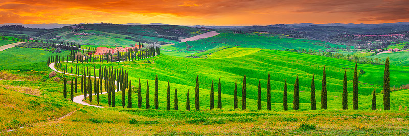
Sunset at Baccoleno, Crete Senesi, Tuscany, Italy 4 Aug 2023 7:31 PM (last year)
Sunset at Baccoleno, Crete Senesi, Tuscany, Italy.
One of the classic shots from Tuscany is this view of Baccoleno Farmhouse (Agriturismo). This is one of the most photographed not only of the Crete Senesi but of all Tuscany. This is the famous road lined with cypress trees with a characteristic 'S' shape. One of the most famous photos on postcards, desktops and calendars. A wonderful village situated at the top of one of the gentle hills which follow one another in the heart of the Crete Senesi. From every corner of the building there are views that take one's breath away. Baccoleno is everyone's Tuscan dream; it has a wonderful view, an evocative atmosphere, nicely furnished apartments and a swimming pool with a 'convertible' function.
.%20This%20is%20one%20of%20the%20most%20photographed%20not%20only%20of%20the%20Crete%20Senesi%20but%20of%20all%20Tuscany.%20This%20is%20the%20famous%20road%20lined%20with%20cypress%20trees%20with%20a%20characteristic%20'S'%20shape.%20One%20of%20the%20most%20famous%20photos%20on%20postcards,%20desktops%20and%20calendars.%20A%20wonderful%20village%20situated%20at%20the%20top%20of%20one%20of%20the%20gentle%20hills%20which%20follow%20one%20another%20in%20the%20heart%20of%20the%20Crete%20Senesi.%20From%20every%20corner%20of%20the%20building%20there%20are%20views%20that%20take%20one's%20breath%20away.%20Baccoleno%20is%20everyone's%20Tuscan%20dream;%20it%20has%20a%20wonderful%20view,%20an%20evocative%20atmosphere,%20nicely%20furnished%20apartments%20and%20a%20swimming%20pool%20with%20a%20'convertible'%20function.%22%20/%3E%3C/a%3E%0A%3Cbr%20/%3E%0A%3Cb%3ESunset%20at%20Baccoleno,%20Crete%20Senesi,%20Tuscany,%20Italy%3C/b%3E.%0A%3Cbr%20/%3EOne%20of%20the%20classic%20shots%20from%20Tuscany%20is%20this%20view%20of%20Baccoleno%20Farmhouse%20(Agriturismo).%20This%20is%20one%20of%20the%20most%20photographed%20not%20only%20of%20the%20Crete%20Senesi%20but%20of%20all%20Tuscany.%20This%20is%20the%20famous%20road%20lined%20with%20cypress%20trees%20with%20a%20characteristic%20'S'%20shape.%20One%20of%20the%20most%20famous%20photos%20on%20postcards,%20desktops%20and%20calendars.%20A%20wonderful%20village%20situated%20at%20the%20top%20of%20one%20of%20the%20gentle%20hills%20which%20follow%20one%20another%20in%20the%20heart%20of%20the%20Crete%20Senesi.%20From%20every%20corner%20of%20the%20building%20there%20are%20views%20that%20take%20one's%20breath%20away.%20Baccoleno%20is%20everyone's%20Tuscan%20dream;%20it%20has%20a%20wonderful%20view,%20an%20evocative%20atmosphere,%20nicely%20furnished%20apartments%20and%20a%20swimming%20pool%20with%20a%20'convertible'%20function.%3C/p%3E)
Sunset at Villa I Cipressini, Pienza, Val d'Orcia, Tuscany, Italy 4 Aug 2023 7:30 PM (last year)
Sunset at Villa I Cipressini, Pienza, Val d'Orcia, Tuscany, Italy.
Tuscany is the typical hilly landscape, with cypress trees and hay bales, and the most iconic is definitely Val d'Orcia. Constantly atmospheric, it is green in springtime, golden and ochre during summer and foggy in Autumn, it will always enchant you. Val d'Orcia is a large valley located in the south of Tuscany and the most scenic route is the road SP438 from Siena to Asciano. This area is called 'Crete Senesi'. Then from Asciano the road SP60 proceeding along road SP14 and there will be Val d'Orcia. Cypress avenues meet picturesque agriturismo. And the backdrop: a lush, hilly, picturesque, expansive landscape. Val d'Orcia is renowned as one of the best photo-spots in Tuscany. Enjoy the view of the quintessential image of Tuscany that inspired many painters of the Renaissance and which is a UNESCO World Heritage site.

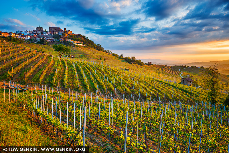
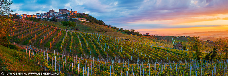
Roddi and Hills of Barolo at Sunrise, Cuneo, Piedmont, Italy 15 Jul 2023 9:58 PM (last year)
Roddi and Hills of Barolo at Sunrise, Cuneo, Piedmont, Italy.
Roddi is an ancient old town and it's located immediately outside of Alba, its medieval castle can be seen from the city, as it stands on top of a steep hill. Roddi is part of the 11 municipalities where Barolo wine is grown and offers an easy opportunity to learn about the history and culture of the Langhe region without having to travel too far from its main centre.

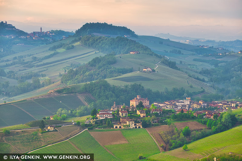
Sunrise at La Morra, Cuneo, Piedmont, Italy 15 Jul 2023 9:57 PM (last year)
Sunrise at La Morra, Cuneo, Piedmont, Italy.
La Morra is a town blessed with the most beautiful position. The views from the town are wonderful. This is serious wine country with many Nebbiolo-Barolo vineyards and capable wine producers. The small, pretty village of La Morra is the focal point for what is in fact the largest commune in the appellation, both in terms of production and area under vine. The wines of La Morra have a reputation for elegance, perfume, and finesse, even if the reality is a little more complex. Given that there are 62 wineries physically located in La Morra, and many who vinify wine from the area elsewhere, it is unsurprising that La Morra plays host to a wide range of Barolo styles.

Hills of Barolo in the Morning, Cuneo, Piedmont, Italy 15 Jul 2023 9:47 PM (last year)
Hills of Barolo in the Morning, Cuneo, Piedmont, Italy.
The township of Barolo is located in the Langhe hills south of the truffle capital Alba in the Cuneo province of Piedmont, and functions both physically and metaphorically as the heart of the region. The village of Barolo has given name to the wines, and the 750 inhabitants receive a very large number of tourists. They come to taste the grapes and see the wine museum WiMu that has been established in a thousand year old castle. There's also a charming cork screw museum, and several cafes, restaurants and wine bars. Unlike most of the other villages in the area, Barolo is not located on a hilltop but halfway down an valley.

Sunrise at La Morra, Cuneo, Piedmont, Italy 16 Jun 2023 10:48 PM (last year)
Sunrise at La Morra, Cuneo, Piedmont, Italy.
La Morra is a comune (municipality) in the Province of Cuneo in the Italian region Piedmont, located about 50 kilometres southeast of Turin. The centre of the small village of La Morra perched on a hill at the height of 513m above sea level, is one of the most striking observation's points of Langa landscape. La Morra is a stunning hilltop medieval village that overlooks the patchwork of vineyards, offers magnificent views, and boasts a rich history. La Morra is part of the Langhe area extending to the south of the Piedmont region. The Langhe area is famous for its hilltop castles and fortresses. This region is known for producing some of Italy's best wines, Barolo. Other notable wines of the area are Barbaresco, Barbera, Dolcetto d'Alba, and Moscato d'Asti.
%20in%20the%20Province%20of%20Cuneo%20in%20the%20Italian%20region%20Piedmont,%20located%20about%2050%20kilometres%20southeast%20of%20Turin.%20The%20centre%20of%20the%20small%20village%20of%20La%20Morra%20perched%20on%20a%20hill%20at%20the%20height%20of%20513m%20above%20sea%20level,%20is%20one%20of%20the%20most%20striking%20observation's%20points%20of%20Langa%20landscape.%20La%20Morra%20is%20a%20stunning%20hilltop%20medieval%20village%20that%20overlooks%20the%20patchwork%20of%20vineyards,%20offers%20magnificent%20views,%20and%20boasts%20a%20rich%20history.%20La%20Morra%20is%20part%20of%20the%20Langhe%20area%20extending%20to%20the%20south%20of%20the%20Piedmont%20region.%20The%20Langhe%20area%20is%20famous%20for%20its%20hilltop%20castles%20and%20fortresses.%20This%20region%20is%20known%20for%20producing%20some%20of%20Italy's%20best%20wines,%20Barolo.%20Other%20notable%20wines%20of%20the%20area%20are%20Barbaresco,%20Barbera,%20Dolcetto%20d'Alba,%20and%20Moscato%20d'Asti.%22%20/%3E%3C/a%3E%3Cbr%20/%3E%0A%3Cb%3ESunrise%20at%20La%20Morra,%20Cuneo,%20Piedmont,%20Italy%3C/b%3E.%3Cbr%20/%3E%0ALa%20Morra%20is%20a%20comune%20(municipality)%20in%20the%20Province%20of%20Cuneo%20in%20the%20Italian%20region%20Piedmont,%20located%20about%2050%20kilometres%20southeast%20of%20Turin.%20The%20centre%20of%20the%20small%20village%20of%20La%20Morra%20perched%20on%20a%20hill%20at%20the%20height%20of%20513m%20above%20sea%20level,%20is%20one%20of%20the%20most%20striking%20observation's%20points%20of%20Langa%20landscape.%20La%20Morra%20is%20a%20stunning%20hilltop%20medieval%20village%20that%20overlooks%20the%20patchwork%20of%20vineyards,%20offers%20magnificent%20views,%20and%20boasts%20a%20rich%20history.%20La%20Morra%20is%20part%20of%20the%20Langhe%20area%20extending%20to%20the%20south%20of%20the%20Piedmont%20region.%20The%20Langhe%20area%20is%20famous%20for%20its%20hilltop%20castles%20and%20fortresses.%20This%20region%20is%20known%20for%20producing%20some%20of%20Italy's%20best%20wines,%20Barolo.%20Other%20notable%20wines%20of%20the%20area%20are%20Barbaresco,%20Barbera,%20Dolcetto%20d'Alba,%20and%20Moscato%20d'Asti.)
Sacra di San Michele, Sant'Ambrogio, Piedmont, Italy 16 Jun 2023 10:47 PM (last year)
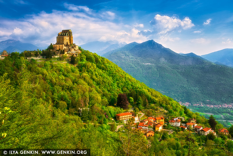
Sacra di San Michele, Sant'Ambrogio, Piedmont, Italy.
The Sacra di San Michele, sometimes known as Saint Michael's Abbey, is an ancient medieval abbey in Val di Susa on Mount Pirchiriano, is one of the landmarks of the Piedmont. A special regional law acknowledges it as the 'Symbolic monument of the Piedmont region'. The Sacra di San Michele evokes beauty, charm, and mystery - that mystery that has enveloped it right from its construction, which occurred between 983 and 987 AD. It is a wonderful place, dense with spirituality; originally protected by the Benedictine monks, since 1837, it has been entrusted to the Rosminian Fathers. The history, the spiritual value, and landscape that surrounds it inspired Umberto Eco to write his best-seller The Name of the Rose and make the Sacra a popular destination for visitors from all over Europe. It is also one of the most enchanting places in Italy, important not only for tourism, but also for Italian history and literature. A source of inspiration for countless forms of art, it has always evoked an intense mystical atmosphere frozen in time.

The Colosseum at Sunrise, Rome, Lazio, Italy 11 Jun 2023 9:52 PM (last year)
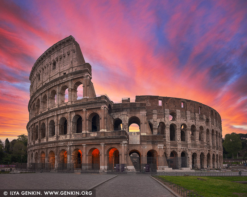
The Colosseum at Sunrise, Rome, Lazio, Italy.
The Colosseum is an elliptical amphitheatre in the centre of the city of Rome, Italy, just east of the Roman Forum. It is the largest ancient amphitheatre ever built, and is still the largest standing amphitheatre in the world, despite its age. The Colosseum is the main symbol of Rome. It's an imposing construction that, with almost 2,000 years of history, will bring you back in time to discover the way of life in the Roman Empire. During the Roman Empire and under the motto of 'Bread and Circuses' the Roman Colosseum (known then as Flavian Amphitheatre) allowed more than 50,000 people to enjoy its finest spectacles. The exhibitions of exotic animals, executions of prisoners, recreations of battles, and gladiator fights kept the Roman people entertained for years. The Colosseum remained active for over 500 years. The last recorded games in history were celebrated in the 6th century. In medieval times, the Colosseum was used as a church, then as a fortress by two prominent Roman families, the Frangipane and the Annibaldi. The Colosseum was damaged by lightning and earthquakes and, even more severely, by vandalism and pollution. All the marble seats and decorative materials disappeared, as the site was treated as little more than a quarry for more than 1,000 years. Preservation of the Colosseum began in earnest in the 19th century, with notable efforts led by Pius VIII, and a restoration project was undertaken in the 1990s. It has long been one of Rome's major tourist attractions, receiving close to seven million visitors annually. Changing exhibitions relating to the culture of ancient Rome are regularly mounted.
%20allowed%20more%20than%2050,000%20people%20to%20enjoy%20its%20finest%20spectacles.%20The%20exhibitions%20of%20exotic%20animals,%20executions%20of%20prisoners,%20recreations%20of%20battles,%20and%20gladiator%20fights%20kept%20the%20Roman%20people%20entertained%20for%20years.%20The%20Colosseum%20remained%20active%20for%20over%20500%20years.%20The%20last%20recorded%20games%20in%20history%20were%20celebrated%20in%20the%206th%20century.%20In%20medieval%20times,%20the%20Colosseum%20was%20used%20as%20a%20church,%20then%20as%20a%20fortress%20by%20two%20prominent%20Roman%20families,%20the%20Frangipane%20and%20the%20Annibaldi.%20The%20Colosseum%20was%20damaged%20by%20lightning%20and%20earthquakes%20and,%20even%20more%20severely,%20by%20vandalism%20and%20pollution.%20All%20the%20marble%20seats%20and%20decorative%20materials%20disappeared,%20as%20the%20site%20was%20treated%20as%20little%20more%20than%20a%20quarry%20for%20more%20than%201,000%20years.%20Preservation%20of%20the%20Colosseum%20began%20in%20earnest%20in%20the%2019th%20century,%20with%20notable%20efforts%20led%20by%20Pius%20VIII,%20and%20a%20restoration%20project%20was%20undertaken%20in%20the%201990s.%20It%20has%20long%20been%20one%20of%20Rome's%20major%20tourist%20attractions,%20receiving%20close%20to%20seven%20million%20visitors%20annually.%20Changing%20exhibitions%20relating%20to%20the%20culture%20of%20ancient%20Rome%20are%20regularly%20mounted.%22%20/%3E%3C/a%3E%3Cbr%20/%3E%0A%3Cb%3EThe%20Colosseum%20at%20Sunrise,%20Rome,%20Lazio,%20Italy%3C/b%3E.%3Cbr%20/%3E%0AThe%20Colosseum%20is%20an%20elliptical%20amphitheatre%20in%20the%20centre%20of%20the%20city%20of%20Rome,%20Italy,%20just%20east%20of%20the%20Roman%20Forum.%20It%20is%20the%20largest%20ancient%20amphitheatre%20ever%20built,%20and%20is%20still%20the%20largest%20standing%20amphitheatre%20in%20the%20world,%20despite%20its%20age.%20The%20Colosseum%20is%20the%20main%20symbol%20of%20Rome.%20It's%20an%20imposing%20construction%20that,%20with%20almost%202,000%20years%20of%20history,%20will%20bring%20you%20back%20in%20time%20to%20discover%20the%20way%20of%20life%20in%20the%20Roman%20Empire.%20During%20the%20Roman%20Empire%20and%20under%20the%20motto%20of%20'Bread%20and%20Circuses'%20the%20Roman%20Colosseum%20(known%20then%20as%20Flavian%20Amphitheatre)%20allowed%20more%20than%2050,000%20people%20to%20enjoy%20its%20finest%20spectacles.%20The%20exhibitions%20of%20exotic%20animals,%20executions%20of%20prisoners,%20recreations%20of%20battles,%20and%20gladiator%20fights%20kept%20the%20Roman%20people%20entertained%20for%20years.%20The%20Colosseum%20remained%20active%20for%20over%20500%20years.%20The%20last%20recorded%20games%20in%20history%20were%20celebrated%20in%20the%206th%20century.%20In%20medieval%20times,%20the%20Colosseum%20was%20used%20as%20a%20church,%20then%20as%20a%20fortress%20by%20two%20prominent%20Roman%20families,%20the%20Frangipane%20and%20the%20Annibaldi.%20The%20Colosseum%20was%20damaged%20by%20lightning%20and%20earthquakes%20and,%20even%20more%20severely,%20by%20vandalism%20and%20pollution.%20All%20the%20marble%20seats%20and%20decorative%20materials%20disappeared,%20as%20the%20site%20was%20treated%20as%20little%20more%20than%20a%20quarry%20for%20more%20than%201,000%20years.%20Preservation%20of%20the%20Colosseum%20began%20in%20earnest%20in%20the%2019th%20century,%20with%20notable%20efforts%20led%20by%20Pius%20VIII,%20and%20a%20restoration%20project%20was%20undertaken%20in%20the%201990s.%20It%20has%20long%20been%20one%20of%20Rome's%20major%20tourist%20attractions,%20receiving%20close%20to%20seven%20million%20visitors%20annually.%20Changing%20exhibitions%20relating%20to%20the%20culture%20of%20ancient%20Rome%20are%20regularly%20mounted.)
The Roman Forum at Sunrise, Rome, Lazio, Italy 11 Jun 2023 9:52 PM (last year)
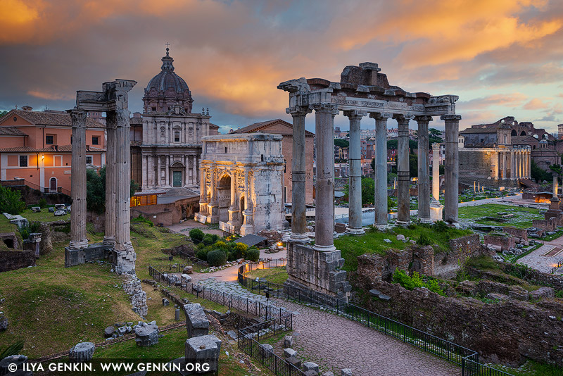
The Roman Forum at Sunrise, Rome, Lazio, Italy.
The Roman Forum, also known by its Latin name Forum Romanum, is a rectangular forum (plaza) surrounded by the ruins of several important ancient government buildings at the center of the city of Rome. Citizens of the ancient city referred to this space, originally a marketplace, as the Forum Magnum, or simply the Forum. It is situated on low ground between the Palatine and Capitoline hills. The Roman Forum was the scene of public meetings, law courts, and gladiatorial combats in republican times and was lined with shops and open-air markets. Under the empire, when it primarily became a centre for religious and secular spectacles and ceremonies, it was the site of many of the city's most imposing temples and monuments. Among the structures surviving in whole or in part are the Temple of Castor and Pollux, the Temple of the Deified Caesar, the Mamertine Prison, the Curia (senate house), the Temple of Saturn, the Temple of Vesta, the Temple of Romulus, the Arch of Titus, the Arch of Septimius Severus, and the Cloaca Maxima.
%20surrounded%20by%20the%20ruins%20of%20several%20important%20ancient%20government%20buildings%20at%20the%20center%20of%20the%20city%20of%20Rome.%20Citizens%20of%20the%20ancient%20city%20referred%20to%20this%20space,%20originally%20a%20marketplace,%20as%20the%20Forum%20Magnum,%20or%20simply%20the%20Forum.%20It%20is%20situated%20on%20low%20ground%20between%20the%20Palatine%20and%20Capitoline%20hills.%20The%20Roman%20Forum%20was%20the%20scene%20of%20public%20meetings,%20law%20courts,%20and%20gladiatorial%20combats%20in%20republican%20times%20and%20was%20lined%20with%20shops%20and%20open-air%20markets.%20Under%20the%20empire,%20when%20it%20primarily%20became%20a%20centre%20for%20religious%20and%20secular%20spectacles%20and%20ceremonies,%20it%20was%20the%20site%20of%20many%20of%20the%20city's%20most%20imposing%20temples%20and%20monuments.%20Among%20the%20structures%20surviving%20in%20whole%20or%20in%20part%20are%20the%20Temple%20of%20Castor%20and%20Pollux,%20the%20Temple%20of%20the%20Deified%20Caesar,%20the%20Mamertine%20Prison,%20the%20Curia%20(senate%20house),%20the%20Temple%20of%20Saturn,%20the%20Temple%20of%20Vesta,%20the%20Temple%20of%20Romulus,%20the%20Arch%20of%20Titus,%20the%20Arch%20of%20Septimius%20Severus,%20and%20the%20Cloaca%20Maxima.%22%20/%3E%3C/a%3E%3Cbr%20/%3E%0A%3Cb%3EThe%20Roman%20Forum%20at%20Sunrise,%20Rome,%20Lazio,%20Italy%3C/b%3E.%3Cbr%20/%3E%0AThe%20Roman%20Forum,%20also%20known%20by%20its%20Latin%20name%20Forum%20Romanum,%20is%20a%20rectangular%20forum%20(plaza)%20surrounded%20by%20the%20ruins%20of%20several%20important%20ancient%20government%20buildings%20at%20the%20center%20of%20the%20city%20of%20Rome.%20Citizens%20of%20the%20ancient%20city%20referred%20to%20this%20space,%20originally%20a%20marketplace,%20as%20the%20Forum%20Magnum,%20or%20simply%20the%20Forum.%20It%20is%20situated%20on%20low%20ground%20between%20the%20Palatine%20and%20Capitoline%20hills.%20The%20Roman%20Forum%20was%20the%20scene%20of%20public%20meetings,%20law%20courts,%20and%20gladiatorial%20combats%20in%20republican%20times%20and%20was%20lined%20with%20shops%20and%20open-air%20markets.%20Under%20the%20empire,%20when%20it%20primarily%20became%20a%20centre%20for%20religious%20and%20secular%20spectacles%20and%20ceremonies,%20it%20was%20the%20site%20of%20many%20of%20the%20city's%20most%20imposing%20temples%20and%20monuments.%20Among%20the%20structures%20surviving%20in%20whole%20or%20in%20part%20are%20the%20Temple%20of%20Castor%20and%20Pollux,%20the%20Temple%20of%20the%20Deified%20Caesar,%20the%20Mamertine%20Prison,%20the%20Curia%20(senate%20house),%20the%20Temple%20of%20Saturn,%20the%20Temple%20of%20Vesta,%20the%20Temple%20of%20Romulus,%20the%20Arch%20of%20Titus,%20the%20Arch%20of%20Septimius%20Severus,%20and%20the%20Cloaca%20Maxima.)
Saint Peter's Basilica at Sunset, Vatican City, Rome, Lazio, Italy 11 Jun 2023 9:51 PM (last year)
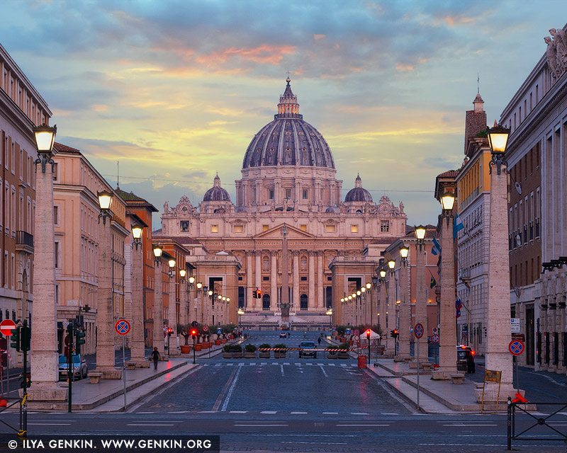
Saint Peter's Basilica at Sunset, Vatican City, Rome, Lazio, Italy.
The Papal Basilica of Saint Peter in the Vatican (Basilica Papale di San Pietro in Vaticano), or simply Saint Peter's Basilica (Basilica Sancti Petri), is a church built in the Renaissance style located in Vatican City, the papal enclave that is within the city of Rome, Italy. It was initially planned by Pope Nicholas V and then Pope Julius II to replace the aging Old St. Peter's Basilica, which was built in the fourth century by Roman emperor Constantine the Great. Designed principally by Donato Bramante, Michelangelo, Carlo Maderno and Gian Lorenzo Bernini, St. Peter's is the most renowned work of Renaissance architecture and the largest church in the world by interior measure. While it is neither the mother church of the Catholic Church nor the cathedral of the Diocese of Rome, St. Peter's is regarded as one of the holiest Catholic shrines. It has been described as 'holding a unique position in the Christian world', and as 'the greatest of all churches of Christendom.'
,%20or%20simply%20Saint%20Peter's%20Basilica%20(Basilica%20Sancti%20Petri),%20is%20a%20church%20built%20in%20the%20Renaissance%20style%20located%20in%20Vatican%20City,%20the%20papal%20enclave%20that%20is%20within%20the%20city%20of%20Rome,%20Italy.%20It%20was%20initially%20planned%20by%20Pope%20Nicholas%20V%20and%20then%20Pope%20Julius%20II%20to%20replace%20the%20aging%20Old%20St.%20Peter's%20Basilica,%20which%20was%20built%20in%20the%20fourth%20century%20by%20Roman%20emperor%20Constantine%20the%20Great.%20Designed%20principally%20by%20Donato%20Bramante,%20Michelangelo,%20Carlo%20Maderno%20and%20Gian%20Lorenzo%20Bernini,%20St.%20Peter's%20is%20the%20most%20renowned%20work%20of%20Renaissance%20architecture%20and%20the%20largest%20church%20in%20the%20world%20by%20interior%20measure.%20While%20it%20is%20neither%20the%20mother%20church%20of%20the%20Catholic%20Church%20nor%20the%20cathedral%20of%20the%20Diocese%20of%20Rome,%20St.%20Peter's%20is%20regarded%20as%20one%20of%20the%20holiest%20Catholic%20shrines.%20It%20has%20been%20described%20as%20'holding%20a%20unique%20position%20in%20the%20Christian%20world',%20and%20as%20'the%20greatest%20of%20all%20churches%20of%20Christendom.'%22%20/%3E%3C/a%3E%3Cbr%20/%3E%0A%3Cb%3ESaint%20Peter's%20Basilica%20at%20Sunset,%20Vatican%20City,%20Rome,%20Lazio,%20Italy%3C/b%3E.%3Cbr%20/%3E%0AThe%20Papal%20Basilica%20of%20Saint%20Peter%20in%20the%20Vatican%20(Basilica%20Papale%20di%20San%20Pietro%20in%20Vaticano),%20or%20simply%20Saint%20Peter's%20Basilica%20(Basilica%20Sancti%20Petri),%20is%20a%20church%20built%20in%20the%20Renaissance%20style%20located%20in%20Vatican%20City,%20the%20papal%20enclave%20that%20is%20within%20the%20city%20of%20Rome,%20Italy.%20It%20was%20initially%20planned%20by%20Pope%20Nicholas%20V%20and%20then%20Pope%20Julius%20II%20to%20replace%20the%20aging%20Old%20St.%20Peter's%20Basilica,%20which%20was%20built%20in%20the%20fourth%20century%20by%20Roman%20emperor%20Constantine%20the%20Great.%20Designed%20principally%20by%20Donato%20Bramante,%20Michelangelo,%20Carlo%20Maderno%20and%20Gian%20Lorenzo%20Bernini,%20St.%20Peter's%20is%20the%20most%20renowned%20work%20of%20Renaissance%20architecture%20and%20the%20largest%20church%20in%20the%20world%20by%20interior%20measure.%20While%20it%20is%20neither%20the%20mother%20church%20of%20the%20Catholic%20Church%20nor%20the%20cathedral%20of%20the%20Diocese%20of%20Rome,%20St.%20Peter's%20is%20regarded%20as%20one%20of%20the%20holiest%20Catholic%20shrines.%20It%20has%20been%20described%20as%20'holding%20a%20unique%20position%20in%20the%20Christian%20world',%20and%20as%20'the%20greatest%20of%20all%20churches%20of%20Christendom.')
St. Angelo Bridge and Vatican City from Umberto I Bridge, Rome, Lazio, Italy 11 Jun 2023 9:51 PM (last year)
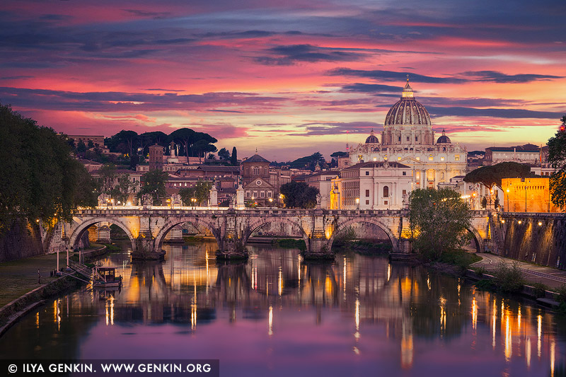
St. Angelo Bridge and Vatican City from Umberto I Bridge, Rome, Lazio, Italy.
Ponte Sant'Angelo and the dome of St Peter's Basilica, as seen from Ponte Umberto I - A bridge with a view. Ponte Sant'Angelo, ancient Pons Aelius, ancient Roman bridge, probably the finest surviving in Rome itself, built over the Tiber River by the emperor Hadrian (reigned 117-138 AD) to connect the Campus Martius with his mausoleum (later renamed Castel Sant'Angelo). Ponte Sant'Angelo is Rome's most beautiful bridge, with ten magnificent marble angels lining both sides of the bridge. The bridge's three central arches are still the originals from the ancient Roman era. In the seventeenth century two more arches were added, one on either side, to replace the original ramps that lead to the bridge. The bridge was further modified in the nineteenth century when the Tiber embankment was built to protect the city from floodwater. Today the bridge is pedestrianized; tourists pass here on their way to the Castel Sant'Angelo and the Vatican.
%20to%20connect%20the%20Campus%20Martius%20with%20his%20mausoleum%20(later%20renamed%20Castel%20Sant'Angelo).%20Ponte%20Sant'Angelo%20is%20Rome's%20most%20beautiful%20bridge,%20with%20ten%20magnificent%20marble%20angels%20lining%20both%20sides%20of%20the%20bridge.%20The%20bridge's%20three%20central%20arches%20are%20still%20the%20originals%20from%20the%20ancient%20Roman%20era.%20In%20the%20seventeenth%20century%20two%20more%20arches%20were%20added,%20one%20on%20either%20side,%20to%20replace%20the%20original%20ramps%20that%20lead%20to%20the%20bridge.%20The%20bridge%20was%20further%20modified%20in%20the%20nineteenth%20century%20when%20the%20Tiber%20embankment%20was%20built%20to%20protect%20the%20city%20from%20floodwater.%20Today%20the%20bridge%20is%20pedestrianized;%20tourists%20pass%20here%20on%20their%20way%20to%20the%20Castel%20Sant'Angelo%20and%20the%20Vatican.%22%20/%3E%3C/a%3E%3Cbr%20/%3E%0A%3Cb%3ESt.%20Angelo%20Bridge%20and%20Vatican%20City%20from%20Umberto%20I%20Bridge,%20Rome,%20Lazio,%20Italy%3C/b%3E.%3Cbr%20/%3E%0APonte%20Sant'Angelo%20and%20the%20dome%20of%20St%20Peter's%20Basilica,%20as%20seen%20from%20Ponte%20Umberto%20I%20-%20A%20bridge%20with%20a%20view.%20Ponte%20Sant'Angelo,%20ancient%20Pons%20Aelius,%20ancient%20Roman%20bridge,%20probably%20the%20finest%20surviving%20in%20Rome%20itself,%20built%20over%20the%20Tiber%20River%20by%20the%20emperor%20Hadrian%20(reigned%20117-138%20AD)%20to%20connect%20the%20Campus%20Martius%20with%20his%20mausoleum%20(later%20renamed%20Castel%20Sant'Angelo).%20Ponte%20Sant'Angelo%20is%20Rome's%20most%20beautiful%20bridge,%20with%20ten%20magnificent%20marble%20angels%20lining%20both%20sides%20of%20the%20bridge.%20The%20bridge's%20three%20central%20arches%20are%20still%20the%20originals%20from%20the%20ancient%20Roman%20era.%20In%20the%20seventeenth%20century%20two%20more%20arches%20were%20added,%20one%20on%20either%20side,%20to%20replace%20the%20original%20ramps%20that%20lead%20to%20the%20bridge.%20The%20bridge%20was%20further%20modified%20in%20the%20nineteenth%20century%20when%20the%20Tiber%20embankment%20was%20built%20to%20protect%20the%20city%20from%20floodwater.%20Today%20the%20bridge%20is%20pedestrianized;%20tourists%20pass%20here%20on%20their%20way%20to%20the%20Castel%20Sant'Angelo%20and%20the%20Vatican.)
Saint Peter's Basilica and Via della Conciliazione at Night, Rome, Lazio, Italy 11 Jun 2023 9:50 PM (last year)
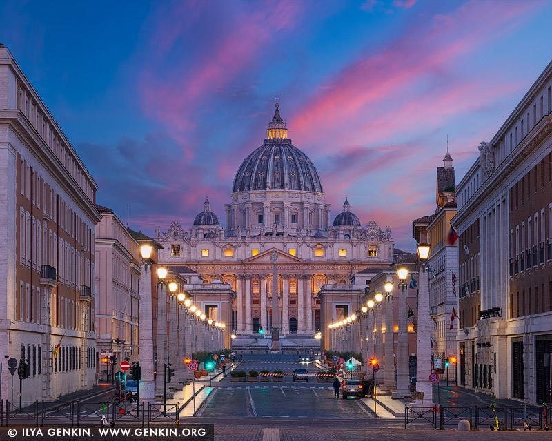
Saint Peter's Basilica and Via della Conciliazione at Night, Rome, Lazio, Italy.
Via della Conciliazione or Road of the Conciliation is one of the main streets in Rome, Italy with a good view of the St. Peter's Basilica. This street leads towards St. Peter's Square. Via della Conciliazione, the broad thoroughfare that leads to St Peter's Basilica, was built between 1936 and 1950. The road was initiated by Mussolini to celebrate the accord reached in 1929 between his government and the papacy, which settled the so-called Roman question. Since the facades of the buildings on either side of the new road did not align perfectly, traffic islands were erected along both sides, complete with rows of stone obelisks (doubling up as lampposts), in order to create the illusion of a perfectly straight thoroughfare.
,%20in%20order%20to%20create%20the%20illusion%20of%20a%20perfectly%20straight%20thoroughfare.%22%20/%3E%3C/a%3E%3Cbr%20/%3E%0A%3Cb%3ESaint%20Peter's%20Basilica%20and%20Via%20della%20Conciliazione%20at%20Night,%20Rome,%20Lazio,%20Italy%3C/b%3E.%3Cbr%20/%3E%0AVia%20della%20Conciliazione%20or%20Road%20of%20the%20Conciliation%20is%20one%20of%20the%20main%20streets%20in%20Rome,%20Italy%20with%20a%20good%20view%20of%20the%20St.%20Peter's%20Basilica.%20This%20street%20leads%20towards%20St.%20Peter's%20Square.%20Via%20della%20Conciliazione,%20the%20broad%20thoroughfare%20that%20leads%20to%20St%20Peter's%20Basilica,%20was%20built%20between%201936%20and%201950.%20The%20road%20was%20initiated%20by%20Mussolini%20to%20celebrate%20the%20accord%20reached%20in%201929%20between%20his%20government%20and%20the%20papacy,%20which%20settled%20the%20so-called%20Roman%20question.%20Since%20the%20facades%20of%20the%20buildings%20on%20either%20side%20of%20the%20new%20road%20did%20not%20align%20perfectly,%20traffic%20islands%20were%20erected%20along%20both%20sides,%20complete%20with%20rows%20of%20stone%20obelisks%20(doubling%20up%20as%20lampposts),%20in%20order%20to%20create%20the%20illusion%20of%20a%20perfectly%20straight%20thoroughfare.)
Camping Under The Stars, Rural NSW, Australia 11 Mar 2023 7:27 PM (2 years ago)
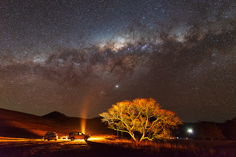
Camping Under The Stars, Rural NSW, Australia.
Is there anything better than camping under the stars - beneath a night sky bursting with the twinkling of thousands of tiny lights? Those of us that get to see it often take it for granted. When you're camping in the country with dark skies, away from cities and their light pollution, it's a breath-taking sight and one that leaves a lasting impression.

Milky Way Galaxy Rising Above Lake Eyre, Kati Thanda - Lake Eyre National Park, South Australia (SA), Australia 11 Mar 2023 1:46 PM (2 years ago)
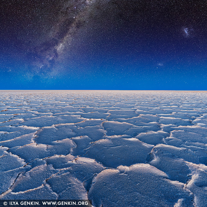
Milky Way Galaxy Rising Above Lake Eyre, Kati Thanda - Lake Eyre National Park, South Australia (SA), Australia.
South Australia has some of the darkest night skies in the world. Plus, being in Earth's southern hemisphere, it shows off one of the best views of the Milky Way Galaxy in the world. In addition, you also get vivid views of the stunning Magellanic Clouds, the Jewel Box cluster of stars and the Southern Cross, which cannot be seen in Europe or America. Kati Thanda - Lake Eyre is absolutely magnificent at night under the light of the Milky Way.
,%20Australia%26bodytext%3D%3Ca%20href%3D%22http://www.genkin.org/cgi-bin/photo.pl/star-trails/milky-way-lake-eyre-0002%22%20title%3D%22Milky%20Way%20Galaxy%20Rising%20Above%20Lake%20Eyre,%20Kati%20Thanda%20-%20Lake%20Eyre%20National%20Park,%20South%20Australia%20(SA),%20Australia%22%3E%3Cimg%20src%3D%22http://www.genkin.org/gallery/star-trails/milky-way-lake-eyre-0002.jpg%22%20alt%3D%22%20stock%20photography%20%7C%20Milky%20Way%20Galaxy%20Rising%20Above%20Lake%20Eyre,%20Kati%20Thanda%20-%20Lake%20Eyre%20National%20Park,%20South%20Australia%20(SA),%20Australia.%20South%20Australia%20has%20some%20of%20the%20darkest%20night%20skies%20in%20the%20world.%20Plus,%20being%20in%20Earth's%20southern%20hemisphere,%20it%20shows%20off%20one%20of%20the%20best%20views%20of%20the%20Milky%20Way%20Galaxy%20in%20the%20world.%20In%20addition,%20you%20also%20get%20vivid%20views%20of%20the%20stunning%20Magellanic%20Clouds,%20the%20Jewel%20Box%20cluster%20of%20stars%20and%20the%20Southern%20Cross,%20which%20cannot%20be%20seen%20in%20Europe%20or%20America.%20Kati%20Thanda%20-%20Lake%20Eyre%20is%20absolutely%20magnificent%20at%20night%20under%20the%20light%20of%20the%20Milky%20Way.%22%20/%3E%3C/a%3E%3Cbr%20/%3E%0A%3Cb%3EMilky%20Way%20Galaxy%20Rising%20Above%20Lake%20Eyre,%20Kati%20Thanda%20-%20Lake%20Eyre%20National%20Park,%20South%20Australia%20(SA),%20Australia%3C/b%3E.%3Cbr%20/%3E%0ASouth%20Australia%20has%20some%20of%20the%20darkest%20night%20skies%20in%20the%20world.%20Plus,%20being%20in%20Earth's%20southern%20hemisphere,%20it%20shows%20off%20one%20of%20the%20best%20views%20of%20the%20Milky%20Way%20Galaxy%20in%20the%20world.%20In%20addition,%20you%20also%20get%20vivid%20views%20of%20the%20stunning%20Magellanic%20Clouds,%20the%20Jewel%20Box%20cluster%20of%20stars%20and%20the%20Southern%20Cross,%20which%20cannot%20be%20seen%20in%20Europe%20or%20America.%20Kati%20Thanda%20-%20Lake%20Eyre%20is%20absolutely%20magnificent%20at%20night%20under%20the%20light%20of%20the%20Milky%20Way.)
Panorama of Milky Way Galaxy Rising Above Lake Eyre, Kati Thanda - Lake Eyre National Park, South Australia (SA), Australia 11 Mar 2023 1:46 PM (2 years ago)
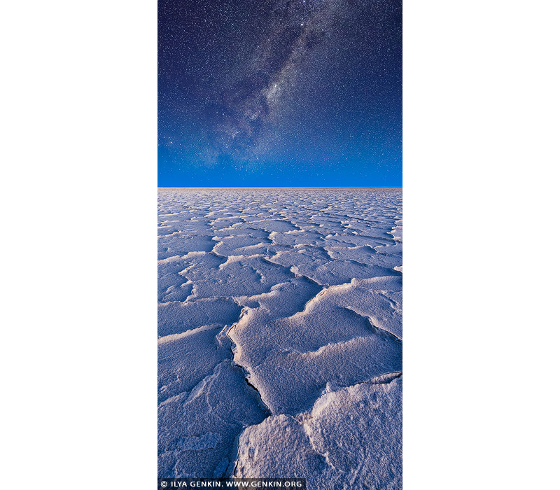
Panorama of Milky Way Galaxy Rising Above Lake Eyre, Kati Thanda - Lake Eyre National Park, South Australia (SA), Australia.
Kati Thana-Lake Eyre National Park is not only home to the Australia's largest salt lake, but is also one of the darkest locations in Australia. Although high altitudes are ideal for stargazing, Kati Thanda-Lake Eyre National Park is an exception to the rule. As the park is 15 meters below sea level - and also Australia's lowest point - it makes it one of the darkest spots in the country. The large, flat salt lake will ensure unobstructed views and when the lake is full, the water reflects the stars from above, creating an absolutely spectacular sight. Experience the awe-inspiring stark wilderness of the park at night by setting up camp at Halligan Bay Point Campground and let the sky put on a show for you - make sure you keep a wish up your sleeve as you might even see a shooting star!
,%20Australia%26bodytext%3D%3Ca%20href%3D%22http://www.genkin.org/cgi-bin/photo.pl/star-trails/milky-way-lake-eyre-0001%22%20title%3D%22Panorama%20of%20Milky%20Way%20Galaxy%20Rising%20Above%20Lake%20Eyre,%20Kati%20Thanda%20-%20Lake%20Eyre%20National%20Park,%20South%20Australia%20(SA),%20Australia%22%3E%3Cimg%20src%3D%22http://www.genkin.org/gallery/star-trails/milky-way-lake-eyre-0001.jpg%22%20alt%3D%22%20stock%20photography%20%7C%20Panorama%20of%20Milky%20Way%20Galaxy%20Rising%20Above%20Lake%20Eyre,%20Kati%20Thanda%20-%20Lake%20Eyre%20National%20Park,%20South%20Australia%20(SA),%20Australia.%20Kati%20Thana-Lake%20Eyre%20National%20Park%20is%20not%20only%20home%20to%20the%20Australia's%20largest%20salt%20lake,%20but%20is%20also%20one%20of%20the%20darkest%20locations%20in%20Australia.%20Although%20high%20altitudes%20are%20ideal%20for%20stargazing,%20Kati%20Thanda-Lake%20Eyre%20National%20Park%20is%20an%20exception%20to%20the%20rule.%20As%20the%20park%20is%2015%20meters%20below%20sea%20level%20-%20and%20also%20Australia's%20lowest%20point%20-%20it%20makes%20it%20one%20of%20the%20darkest%20spots%20in%20the%20country.%20The%20large,%20flat%20salt%20lake%20will%20ensure%20unobstructed%20views%20and%20when%20the%20lake%20is%20full,%20the%20water%20reflects%20the%20stars%20from%20above,%20creating%20an%20absolutely%20spectacular%20sight.%20Experience%20the%20awe-inspiring%20stark%20wilderness%20of%20the%20park%20at%20night%20by%20setting%20up%20camp%20at%20Halligan%20Bay%20Point%20Campground%20and%20let%20the%20sky%20put%20on%20a%20show%20for%20you%20-%20make%20sure%20you%20keep%20a%20wish%20up%20your%20sleeve%20as%20you%20might%20even%20see%20a%20shooting%20star!%22%20/%3E%3C/a%3E%3Cbr%20/%3E%0A%3Cb%3EPanorama%20of%20Milky%20Way%20Galaxy%20Rising%20Above%20Lake%20Eyre,%20Kati%20Thanda%20-%20Lake%20Eyre%20National%20Park,%20South%20Australia%20(SA),%20Australia%3C/b%3E.%3Cbr%20/%3E%0AKati%20Thana-Lake%20Eyre%20National%20Park%20is%20not%20only%20home%20to%20the%20Australia's%20largest%20salt%20lake,%20but%20is%20also%20one%20of%20the%20darkest%20locations%20in%20Australia.%20Although%20high%20altitudes%20are%20ideal%20for%20stargazing,%20Kati%20Thanda-Lake%20Eyre%20National%20Park%20is%20an%20exception%20to%20the%20rule.%20As%20the%20park%20is%2015%20meters%20below%20sea%20level%20-%20and%20also%20Australia's%20lowest%20point%20-%20it%20makes%20it%20one%20of%20the%20darkest%20spots%20in%20the%20country.%20The%20large,%20flat%20salt%20lake%20will%20ensure%20unobstructed%20views%20and%20when%20the%20lake%20is%20full,%20the%20water%20reflects%20the%20stars%20from%20above,%20creating%20an%20absolutely%20spectacular%20sight.%20Experience%20the%20awe-inspiring%20stark%20wilderness%20of%20the%20park%20at%20night%20by%20setting%20up%20camp%20at%20Halligan%20Bay%20Point%20Campground%20and%20let%20the%20sky%20put%20on%20a%20show%20for%20you%20-%20make%20sure%20you%20keep%20a%20wish%20up%20your%20sleeve%20as%20you%20might%20even%20see%20a%20shooting%20star!)
Milky Way over Warrumbungles, Warrumbungle National Park, New South Wales (NSW), Australia 11 Mar 2023 1:45 PM (2 years ago)
Milky Way over Warrumbungles, Warrumbungle National Park, New South Wales (NSW), Australia.
Warrumbungle National Park, near Coonabarabran in central western NSW, is Australia's only Dark Sky Park and the first in the southern hemisphere. The park is renowned for its stargazing opportunities thanks to its crystal-clear night skies, low humidity, high altitude and world-class astronomy research facility at nearby Siding Spring Observatory. Australia's largest optical telescope is within the park boundary and shares the title of the Astronomy capital of Australia with several privately owned public observatories. This and the National Heritage listing makes the Warrumbungle National Park the perfect destination for stargazers, bushwalkers, nature lovers and those looking for a unique experience.
,%20Australia%26bodytext%3D%3Ca%20href%3D%22http://www.genkin.org/cgi-bin/photo.pl/star-trails/milky-way-warrumbungles-0001%22%20title%3D%22Milky%20Way%20over%20Warrumbungles,%20Warrumbungle%20National%20Park,%20New%20South%20Wales%20(NSW),%20Australia%22%3E%3Cimg%20src%3D%22http://www.genkin.org/gallery/star-trails/milky-way-warrumbungles-0001.jpg%22%20alt%3D%22%20stock%20photography%20%7C%20Milky%20Way%20over%20Warrumbungles,%20Warrumbungle%20National%20Park,%20New%20South%20Wales%20(NSW),%20Australia.%20Warrumbungle%20National%20Park,%20near%20Coonabarabran%20in%20central%20western%20NSW,%20is%20Australia's%20only%20Dark%20Sky%20Park%20and%20the%20first%20in%20the%20southern%20hemisphere.%20The%20park%20is%20renowned%20for%20its%20stargazing%20opportunities%20thanks%20to%20its%20crystal-clear%20night%20skies,%20low%20humidity,%20high%20altitude%20and%20world-class%20astronomy%20research%20facility%20at%20nearby%20Siding%20Spring%20Observatory.%20Australia's%20largest%20optical%20telescope%20is%20within%20the%20park%20boundary%20and%20shares%20the%20title%20of%20the%20Astronomy%20capital%20of%20Australia%20with%20several%20privately%20owned%20public%20observatories.%20This%20and%20the%20National%20Heritage%20listing%20makes%20the%20Warrumbungle%20National%20Park%20the%20perfect%20destination%20for%20stargazers,%20bushwalkers,%20nature%20lovers%20and%20those%20looking%20for%20a%20unique%20experience.%22%20/%3E%3C/a%3E%3Cbr%20/%3E%0A%3Cb%3EMilky%20Way%20over%20Warrumbungles,%20Warrumbungle%20National%20Park,%20New%20South%20Wales%20(NSW),%20Australia%3C/b%3E.%3Cbr%20/%3E%0AWarrumbungle%20National%20Park,%20near%20Coonabarabran%20in%20central%20western%20NSW,%20is%20Australia's%20only%20Dark%20Sky%20Park%20and%20the%20first%20in%20the%20southern%20hemisphere.%20The%20park%20is%20renowned%20for%20its%20stargazing%20opportunities%20thanks%20to%20its%20crystal-clear%20night%20skies,%20low%20humidity,%20high%20altitude%20and%20world-class%20astronomy%20research%20facility%20at%20nearby%20Siding%20Spring%20Observatory.%20Australia's%20largest%20optical%20telescope%20is%20within%20the%20park%20boundary%20and%20shares%20the%20title%20of%20the%20Astronomy%20capital%20of%20Australia%20with%20several%20privately%20owned%20public%20observatories.%20This%20and%20the%20National%20Heritage%20listing%20makes%20the%20Warrumbungle%20National%20Park%20the%20perfect%20destination%20for%20stargazers,%20bushwalkers,%20nature%20lovers%20and%20those%20looking%20for%20a%20unique%20experience.)
Milky Way Raising over Cathedral Rocks at Mullimburra Point, Moruya, Eurobodalla, NSW South Coast, NSW, Australia 11 Mar 2023 1:05 PM (2 years ago)
Milky Way Raising over Cathedral Rocks at Mullimburra Point, Moruya, Eurobodalla, NSW South Coast, NSW, Australia.
The Cathedral Rocks at Mullimburra Point are a spectacular natural attraction and an excellent photo opportunity with the best time being in late afternoon light when the setting sun gives the rocks an incandescent-like glow or at night.

Chifley Tower, Sydney, NSW, Australia 28 Dec 2022 2:38 PM (2 years ago)
Chifley Tower, Sydney, NSW, Australia.
Chifley Tower is a skyscraper in Sydney, Australia. It was designed by New York City-based architects Travis McEwen and Kohn Pedersen Fox, with John Rayner as project architect. At a height of 244 metres (801 feet), Chifley Tower was the tallest building in Sydney from 1992 to 2019. It was surpassed in height by Crown Sydney (271 metres) in 2020 along with the Salesforce Tower (263 metres) and One Sydney Harbour (247 metres) in 2022. One of the highlights of the present day Sydney skyline, Chifley Tower is a Post Modern office tower incorporating the latest in structural technology wrapped in a form reminiscent of of the picturesque romantic skyscrapers of early 20th century America. The building was originally named Bond Tower, after Alan Bond. After Bond's bankruptcy, the building was acquired by Kumagai Gumi, and in 1993 was renamed Chifley Tower, after the square. The retail arcade located in the podium building is named Chifley Plaza.
,%20Chifley%20Tower%20was%20the%20tallest%20building%20in%20Sydney%20from%201992%20to%202019.%20It%20was%20surpassed%20in%20height%20by%20Crown%20Sydney%20(271%20metres)%20in%202020%20along%20with%20the%20Salesforce%20Tower%20(263%20metres)%20and%20One%20Sydney%20Harbour%20(247%20metres)%20in%202022.%20One%20of%20the%20highlights%20of%20the%20present%20day%20Sydney%20skyline,%20Chifley%20Tower%20is%20a%20Post%20Modern%20office%20tower%20incorporating%20the%20latest%20in%20structural%20technology%20wrapped%20in%20a%20form%20reminiscent%20of%20of%20the%20picturesque%20romantic%20skyscrapers%20of%20early%2020th%20century%20America.%20The%20building%20was%20originally%20named%20Bond%20Tower,%20after%20Alan%20Bond.%20After%20Bond's%20bankruptcy,%20the%20building%20was%20acquired%20by%20Kumagai%20Gumi,%20and%20in%201993%20was%20renamed%20Chifley%20Tower,%20after%20the%20square.%20The%20retail%20arcade%20located%20in%20the%20podium%20building%20is%20named%20Chifley%20Plaza.%22%20/%3E%3C/a%3E%3Cbr%20/%3E%0A%3Cb%3EChifley%20Tower,%20Sydney,%20NSW,%20Australia%3C/b%3E.%3Cbr%20/%3E%0AChifley%20Tower%20is%20a%20skyscraper%20in%20Sydney,%20Australia.%20It%20was%20designed%20by%20New%20York%20City-based%20architects%20Travis%20McEwen%20and%20Kohn%20Pedersen%20Fox,%20with%20John%20Rayner%20as%20project%20architect.%20At%20a%20height%20of%20244%20metres%20(801%20feet),%20Chifley%20Tower%20was%20the%20tallest%20building%20in%20Sydney%20from%201992%20to%202019.%20It%20was%20surpassed%20in%20height%20by%20Crown%20Sydney%20(271%20metres)%20in%202020%20along%20with%20the%20Salesforce%20Tower%20(263%20metres)%20and%20One%20Sydney%20Harbour%20(247%20metres)%20in%202022.%20One%20of%20the%20highlights%20of%20the%20present%20day%20Sydney%20skyline,%20Chifley%20Tower%20is%20a%20Post%20Modern%20office%20tower%20incorporating%20the%20latest%20in%20structural%20technology%20wrapped%20in%20a%20form%20reminiscent%20of%20of%20the%20picturesque%20romantic%20skyscrapers%20of%20early%2020th%20century%20America.%20The%20building%20was%20originally%20named%20Bond%20Tower,%20after%20Alan%20Bond.%20After%20Bond's%20bankruptcy,%20the%20building%20was%20acquired%20by%20Kumagai%20Gumi,%20and%20in%201993%20was%20renamed%20Chifley%20Tower,%20after%20the%20square.%20The%20retail%20arcade%20located%20in%20the%20podium%20building%20is%20named%20Chifley%20Plaza.)
AMP Tower, Sydney, NSW, Australia 28 Dec 2022 2:37 PM (2 years ago)
AMP Tower, Sydney, NSW, Australia.
Located in Circular Quay at the gateway to Sydney's CBD, 33 Alfred Street (also known as AMP Building) has been a prominent feature on the Sydney skyline for 60 years and remains the home and headquarters of AMP to this day. Opened in 1962 by the Prime Minister at the time, Sir Robert Menzies, the AMP 'Sydney Cove' Building, designed by Peddle Thorp & Walker (now PTW Architects), was Sydney's first to break the city's 150-foot (46-metre) height limit, imposed from 1912. At 117 metres, it was Australia's tallest building, almost double the height of anything else in Sydney at the time. 33 Alfred St's post-war International style was unlike anything Sydney had seen before. The twin crescent towers soared 26 storeys, linked centrally into an H-shape and set free from their podium. An observation deck on the top floor was open to the public, offering Sydneysiders and international travellers views of the city and harbour from a never-before-seen angle. Aluminium and glass curtain walling was used to capture magnificent harbour and district views. It was also one of the first buildings to use seawater air conditioning, requiring an on-site 'frogman' to maintain its water-intake pump house.
%20has%20been%20a%20prominent%20feature%20on%20the%20Sydney%20skyline%20for%2060%20years%20and%20remains%20the%20home%20and%20headquarters%20of%20AMP%20to%20this%20day.%20Opened%20in%201962%20by%20the%20Prime%20Minister%20at%20the%20time,%20Sir%20Robert%20Menzies,%20the%20AMP%20'Sydney%20Cove'%20Building,%20designed%20by%20Peddle%20Thorp%20%26amp;%20Walker%20(now%20PTW%20Architects),%20was%20Sydney's%20first%20to%20break%20the%20city's%20150-foot%20(46-metre)%20height%20limit,%20imposed%20from%201912.%20At%20117%20metres,%20it%20was%20Australia's%20tallest%20building,%20almost%20double%20the%20height%20of%20anything%20else%20in%20Sydney%20at%20the%20time.%2033%20Alfred%20St's%20post-war%20International%20style%20was%20unlike%20anything%20Sydney%20had%20seen%20before.%20The%20twin%20crescent%20towers%20soared%2026%20storeys,%20linked%20centrally%20into%20an%20H-shape%20and%20set%20free%20from%20their%20podium.%20An%20observation%20deck%20on%20the%20top%20floor%20was%20open%20to%20the%20public,%20offering%20Sydneysiders%20and%20international%20travellers%20views%20of%20the%20city%20and%20harbour%20from%20a%20never-before-seen%20angle.%20Aluminium%20and%20glass%20curtain%20walling%20was%20used%20to%20capture%20magnificent%20harbour%20and%20district%20views.%20It%20was%20also%20one%20of%20the%20first%20buildings%20to%20use%20seawater%20air%20conditioning,%20requiring%20an%20on-site%20'frogman'%20to%20maintain%20its%20water-intake%20pump%20house.%22%20/%3E%3C/a%3E%3Cbr%20/%3E%0A%3Cb%3EAMP%20Tower,%20Sydney,%20NSW,%20Australia%3C/b%3E.%3Cbr%20/%3E%0ALocated%20in%20Circular%20Quay%20at%20the%20gateway%20to%20Sydney's%20CBD,%2033%20Alfred%20Street%20(also%20known%20as%20AMP%20Building)%20has%20been%20a%20prominent%20feature%20on%20the%20Sydney%20skyline%20for%2060%20years%20and%20remains%20the%20home%20and%20headquarters%20of%20AMP%20to%20this%20day.%20Opened%20in%201962%20by%20the%20Prime%20Minister%20at%20the%20time,%20Sir%20Robert%20Menzies,%20the%20AMP%20'Sydney%20Cove'%20Building,%20designed%20by%20Peddle%20Thorp%20%26%20Walker%20(now%20PTW%20Architects),%20was%20Sydney's%20first%20to%20break%20the%20city's%20150-foot%20(46-metre)%20height%20limit,%20imposed%20from%201912.%20At%20117%20metres,%20it%20was%20Australia's%20tallest%20building,%20almost%20double%20the%20height%20of%20anything%20else%20in%20Sydney%20at%20the%20time.%2033%20Alfred%20St's%20post-war%20International%20style%20was%20unlike%20anything%20Sydney%20had%20seen%20before.%20The%20twin%20crescent%20towers%20soared%2026%20storeys,%20linked%20centrally%20into%20an%20H-shape%20and%20set%20free%20from%20their%20podium.%20An%20observation%20deck%20on%20the%20top%20floor%20was%20open%20to%20the%20public,%20offering%20Sydneysiders%20and%20international%20travellers%20views%20of%20the%20city%20and%20harbour%20from%20a%20never-before-seen%20angle.%20Aluminium%20and%20glass%20curtain%20walling%20was%20used%20to%20capture%20magnificent%20harbour%20and%20district%20views.%20It%20was%20also%20one%20of%20the%20first%20buildings%20to%20use%20seawater%20air%20conditioning,%20requiring%20an%20on-site%20'frogman'%20to%20maintain%20its%20water-intake%20pump%20house.)
Sydney Tower, Sydney, NSW, Australia 28 Dec 2022 2:37 PM (2 years ago)
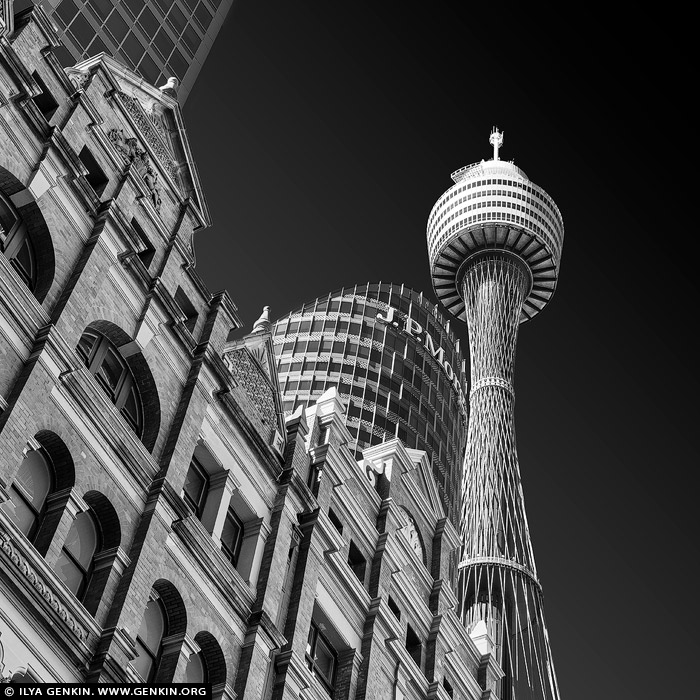
Sydney Tower, Sydney, NSW, Australia.
Sydney Tower Eye (also known as the Sydney Tower, AMP Tower, Westfield Centrepoint Tower, Centrepoint Tower or just Centrepoint, and colloquially as Flower Tower, Glower Tower, and Big Poke) is the city's tallest structure, is one of Sydney's most prominent landmarks. The 309 meter (1014ft) high tower was built in 1981 as a communications tower and tourist facility. Each year, more than a million visitors enjoy the spectacular views over Sydney. Sydney Tower Eye takes you to the highest point above Sydney for breathtaking 360 degree views of the beautiful harbour city. From the golden beaches to the distant Blue Mountains.
%20is%20the%20city's%20tallest%20structure,%20is%20one%20of%20Sydney's%20most%20prominent%20landmarks.%20The%20309%20meter%20(1014ft)%20high%20tower%20was%20built%20in%201981%20as%20a%20communications%20tower%20and%20tourist%20facility.%20Each%20year,%20more%20than%20a%20million%20visitors%20enjoy%20the%20spectacular%20views%20over%20Sydney.%20Sydney%20Tower%20Eye%20takes%20you%20to%20the%20highest%20point%20above%20Sydney%20for%20breathtaking%20360%20degree%20views%20of%20the%20beautiful%20harbour%20city.%20From%20the%20golden%20beaches%20to%20the%20distant%20Blue%20Mountains.%22%20/%3E%3C/a%3E%3Cbr%20/%3E%0A%3Cb%3ESydney%20Tower,%20Sydney,%20NSW,%20Australia%3C/b%3E.%3Cbr%20/%3E%0ASydney%20Tower%20Eye%20(also%20known%20as%20the%20Sydney%20Tower,%20AMP%20Tower,%20Westfield%20Centrepoint%20Tower,%20Centrepoint%20Tower%20or%20just%20Centrepoint,%20and%20colloquially%20as%20Flower%20Tower,%20Glower%20Tower,%20and%20Big%20Poke)%20is%20the%20city's%20tallest%20structure,%20is%20one%20of%20Sydney's%20most%20prominent%20landmarks.%20The%20309%20meter%20(1014ft)%20high%20tower%20was%20built%20in%201981%20as%20a%20communications%20tower%20and%20tourist%20facility.%20Each%20year,%20more%20than%20a%20million%20visitors%20enjoy%20the%20spectacular%20views%20over%20Sydney.%20Sydney%20Tower%20Eye%20takes%20you%20to%20the%20highest%20point%20above%20Sydney%20for%20breathtaking%20360%20degree%20views%20of%20the%20beautiful%20harbour%20city.%20From%20the%20golden%20beaches%20to%20the%20distant%20Blue%20Mountains.)
Rivendell School, Concord West, Sydney, NSW, Australia 28 Dec 2022 1:41 PM (2 years ago)
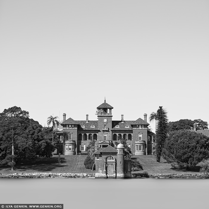
Rivendell School, Concord West, Sydney, NSW, Australia.
The Rivendell School (actually Rivendell Child, Adolescent and Family Unit) in Concord West is located on the banks of the Parramatta River and were originally known as the Thomas Walker Hospital. They were designed by Sir John Sulman and built from 1891-93 by A.M.Allan. The money came from the will of the philanthropist Thomas Walker, who had lived in the Italianate mansion Yaralla, also located at Concord West (and now known as the Dame Eadith Walker Hospital). The buildings are made of brick and sandstone, which is characteristic of the Federation Free Classical style. They feature marble fireplaces and cedar joinery, and are considered an important example of John Sulman's work. They are now listed on the Register of the National Estate. The scenes of the film The Great Gatsby (2013) showing the sanatorium where Nick Carroway visits his psychiatrist were filmed at Rivendell. Scenes from the film 'Flirting' were also filmed at Rivendell.
%20in%20Concord%20West%20is%20located%20on%20the%20banks%20of%20the%20Parramatta%20River%20and%20were%20originally%20known%20as%20the%20Thomas%20Walker%20Hospital.%20They%20were%20designed%20by%20Sir%20John%20Sulman%20and%20built%20from%201891-93%20by%20A.M.Allan.%20The%20money%20came%20from%20the%20will%20of%20the%20philanthropist%20Thomas%20Walker,%20who%20had%20lived%20in%20the%20Italianate%20mansion%20Yaralla,%20also%20located%20at%20Concord%20West%20(and%20now%20known%20as%20the%20Dame%20Eadith%20Walker%20Hospital).%20The%20buildings%20are%20made%20of%20brick%20and%20sandstone,%20which%20is%20characteristic%20of%20the%20Federation%20Free%20Classical%20style.%20They%20feature%20marble%20fireplaces%20and%20cedar%20joinery,%20and%20are%20considered%20an%20important%20example%20of%20John%20Sulman's%20work.%20They%20are%20now%20listed%20on%20the%20Register%20of%20the%20National%20Estate.%20The%20scenes%20of%20the%20film%20The%20Great%20Gatsby%20(2013)%20showing%20the%20sanatorium%20where%20Nick%20Carroway%20visits%20his%20psychiatrist%20were%20filmed%20at%20Rivendell.%20Scenes%20from%20the%20film%20'Flirting'%20were%20also%20filmed%20at%20Rivendell.%22%20/%3E%3C/a%3E%3Cbr%20/%3E%0A%3Cb%3ERivendell%20School,%20Concord%20West,%20Sydney,%20NSW,%20Australia%3C/b%3E.%3Cbr%20/%3E%0AThe%20Rivendell%20School%20(actually%20Rivendell%20Child,%20Adolescent%20and%20Family%20Unit)%20in%20Concord%20West%20is%20located%20on%20the%20banks%20of%20the%20Parramatta%20River%20and%20were%20originally%20known%20as%20the%20Thomas%20Walker%20Hospital.%20They%20were%20designed%20by%20Sir%20John%20Sulman%20and%20built%20from%201891-93%20by%20A.M.Allan.%20The%20money%20came%20from%20the%20will%20of%20the%20philanthropist%20Thomas%20Walker,%20who%20had%20lived%20in%20the%20Italianate%20mansion%20Yaralla,%20also%20located%20at%20Concord%20West%20(and%20now%20known%20as%20the%20Dame%20Eadith%20Walker%20Hospital).%20The%20buildings%20are%20made%20of%20brick%20and%20sandstone,%20which%20is%20characteristic%20of%20the%20Federation%20Free%20Classical%20style.%20They%20feature%20marble%20fireplaces%20and%20cedar%20joinery,%20and%20are%20considered%20an%20important%20example%20of%20John%20Sulman's%20work.%20They%20are%20now%20listed%20on%20the%20Register%20of%20the%20National%20Estate.%20The%20scenes%20of%20the%20film%20The%20Great%20Gatsby%20(2013)%20showing%20the%20sanatorium%20where%20Nick%20Carroway%20visits%20his%20psychiatrist%20were%20filmed%20at%20Rivendell.%20Scenes%20from%20the%20film%20'Flirting'%20were%20also%20filmed%20at%20Rivendell.)
Melbourne, Southbank and Yarra River after Sunrise, Princes Bridge, St Kilda Road, Melbourne, VIC, Australia 26 Dec 2022 4:56 PM (2 years ago)
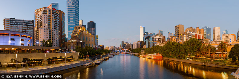
Melbourne, Southbank and Yarra River after Sunrise, Princes Bridge, St Kilda Road, Melbourne, VIC, Australia.
The Princes Bridge is an iconic structure for People of Melbourne due to its position as an extension of Swanston Street connecting to St Kilda Road for crossing the Yarra River. The Bridge is named after, Prince of Wales, later King Edward VII. The area is often used for cultural and sporting events because of its proximity to Flinders Street Station and Federation Square. More than 130 years after its construction, Princes bridge still stands as Melbourne's grandest bridge and as an important and prominent landmark.

Queen Elizabeth Terrace, National Carillon and High Court of Australia at Dusk, Canberra, ACT, Australia 8 Oct 2022 10:50 PM (2 years ago)
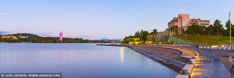
Queen Elizabeth Terrace, National Carillon and High Court of Australia at Dusk, Canberra, ACT, Australia.
The masterful centrepiece of Canberra, the large and lovely Lake Burley Griffin is an ideal water playground, whether you're into rowing, sailing, kayaking, stand-up paddle boarding or fishing. Cyclists and walkers are well catered for along the 40km shoreline, and nothing beats a picnic in its numerous parks and gardens. Queen Elizabeth Terrace is a gorgeous and tranquil promenade, which is excellent for a 30-60 minute slow stroll next to the water, with the beautiful views of lake Burley Griffin.

Storm Clearing over Queen Elizabeth Terrace, National Carillon and High Court of Australia, Canberra, ACT, Australia 8 Oct 2022 10:50 PM (2 years ago)
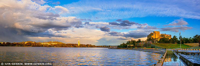
Storm Clearing over Queen Elizabeth Terrace, National Carillon and High Court of Australia, Canberra, ACT, Australia.
Lake Burley Griffin is the social, cultural, recreational and sporting hub of Australia's national capital, Canberra. Canberra's cosmopolitan lifestyle thrives by Lake Burley Griffin. From restaurants, bars and shopping precincts, to museums, galleries, cycle paths, footpaths and open spaces, there is something for everyone, all the time. Lake Burley Griffin is tailor made for sport and recreation. Whether your passion is sailing, kayaking, rowing, swimming, canoeing, fishing, stand-up-paddle boarding, sailboarding or GoBoating, there is something to suit all ages.

Queen Elizabeth Terrace, Lake Burley Griffin and High Court of Australia in the Morning, Canberra, ACT, Australia 8 Oct 2022 7:13 PM (2 years ago)
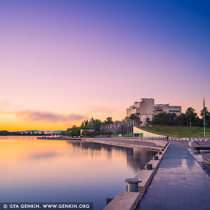
Queen Elizabeth Terrace, Lake Burley Griffin and High Court of Australia in the Morning, Canberra, ACT, Australia.
Queen Elizabeth Terrace is the name of the road along the main foreshore of Lake Burley Griffin. Originally part of Parkes Place, this stretch of waterfront was renamed in 2012, with The Prince of Wales and the Duchess of Cornwall officially opening the road in honour of Her Majesty's Diamond Jubilee celebrations. Queen Elizabeth Terrace is a meeting place, an exercise route, a children's scooter-riding path and a social hub of the Parliamentary Triangle. It should be the first stop for any tourists visiting the city to take in the views and enjoy this lakeside, peaceful setting. It is also a handy location to start exploring the many museums and attractions nearby. Although a short stretch of road, Queen Elizabeth Terrace has a number of attractions located within it for visitors to enjoy.

Late Afternoon at Palm Beach, Sydney, NSW, Australia 8 Oct 2022 5:43 PM (2 years ago)
\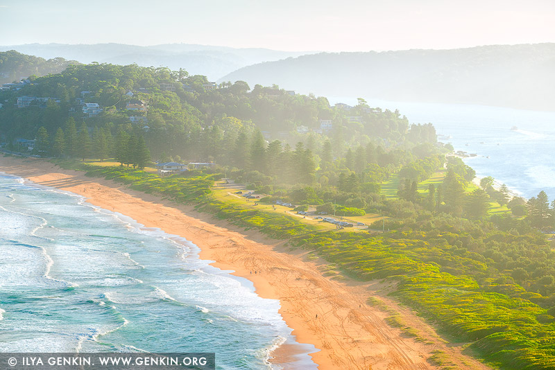
Late Afternoon at Palm Beach, Sydney, NSW, Australia.
The Palm Beach peninsula is one of the most famous beach suburbs in New South Wales, located around 40 kilometres north of the Sydney CBD. The water at the beach facing the ocean can be a bit rough at times due to strong winds. The smaller beach facing Pittwater, also known as Station Beach, on the other side of the peninsula, has much quieter waters and is perfect for a relaxing swim. When visiting Palm Beach, don't forget to visit the Barrenjoey Lighthouse up the hill on the Barrenjoey Headland. The views from there are absolutely stunning, and a short walk will get you there.

The Gap, Watsons Bay, Sydney, NSW, Australia 8 Oct 2022 3:47 PM (2 years ago)
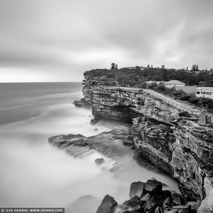
The Gap, Watsons Bay, Sydney, NSW, Australia.
The Gap is one of Sydney's most famous lookout points. From the top of near-vertical ocean cliffs, you look out at breathtaking views across the Tasman Sea. Below you, the waves pound a sandstone plateau and, depending on the weather, you can see spectacular displays as the foamy waves crash in and shoot upwards. The area is one of Sydney's most popular tourist destinations. It attracts international and national tour groups, independent visitors, and local residents who use the park for walking, harbour and ocean viewing, bird watching, whale watching and spectating major harbour events. Additionally the park supports a rich history containing early fortifications, shipwreck relics, and disused gun placements from past wars.

Dover Heights From Vaucluse, Sydney, New South Wales (NSW), Australia 8 Oct 2022 3:45 PM (2 years ago)
Dover Heights From Vaucluse, Sydney, New South Wales (NSW), Australia.
Dover Heights is believed to have been named for its cliffs along the Pacific Ocean which resembled those found at Dover, in Kent, England. The first mention of Dover Heights appeared in municipal records in 1886. The area was first used for market gardens. Dover Heights is a coastal, eastern suburb of Sydney, in the state of New South Wales, Australia. Dover Heights is 9 kilometres east of the Sydney central business district, in the local government area of Waverley Council. The suburb is considered to be the most affluent within the Waverley Local Government Area, and amongst the most affluent suburbs in Australia. This is reflected in property prices. The ATO's 2014-2015 taxation statistics listed Dover Height's as the second richest suburb in Australia.
,%20Australia%26bodytext%3D%3Ca%20href%3D%22http://www.genkin.org/cgi-bin/photo.pl/portfolio/bw-sydney-in-square/sydney-in-square-0020%22%20title%3D%22Dover%20Heights%20From%20Vaucluse,%20Sydney,%20New%20South%20Wales%20(NSW),%20Australia%22%3E%3Cimg%20src%3D%22http://www.genkin.org/gallery/portfolio/bw-sydney-in-square/sydney-in-square-0020.jpg%22%20alt%3D%22portfolio%20stock%20photography%20%7C%20Dover%20Heights%20From%20Vaucluse,%20Sydney,%20New%20South%20Wales%20(NSW),%20Australia.%20Dover%20Heights%20is%20believed%20to%20have%20been%20named%20for%20its%20cliffs%20along%20the%20Pacific%20Ocean%20which%20resembled%20those%20found%20at%20Dover,%20in%20Kent,%20England.%20The%20first%20mention%20of%20Dover%20Heights%20appeared%20in%20municipal%20records%20in%201886.%20The%20area%20was%20first%20used%20for%20market%20gardens.%20Dover%20Heights%20is%20a%20coastal,%20eastern%20suburb%20of%20Sydney,%20in%20the%20state%20of%20New%20South%20Wales,%20Australia.%20Dover%20Heights%20is%209%20kilometres%20east%20of%20the%20Sydney%20central%20business%20district,%20in%20the%20local%20government%20area%20of%20Waverley%20Council.%20The%20suburb%20is%20considered%20to%20be%20the%20most%20affluent%20within%20the%20Waverley%20Local%20Government%20Area,%20and%20amongst%20the%20most%20affluent%20suburbs%20in%20Australia.%20This%20is%20reflected%20in%20property%20prices.%20The%20ATO's%202014-2015%20taxation%20statistics%20listed%20Dover%20Height's%20as%20the%20second%20richest%20suburb%20in%20Australia.%22%20/%3E%3C/a%3E%3Cbr%20/%3E%0A%3Cb%3EDover%20Heights%20From%20Vaucluse,%20Sydney,%20New%20South%20Wales%20(NSW),%20Australia%3C/b%3E.%3Cbr%20/%3E%0ADover%20Heights%20is%20believed%20to%20have%20been%20named%20for%20its%20cliffs%20along%20the%20Pacific%20Ocean%20which%20resembled%20those%20found%20at%20Dover,%20in%20Kent,%20England.%20The%20first%20mention%20of%20Dover%20Heights%20appeared%20in%20municipal%20records%20in%201886.%20The%20area%20was%20first%20used%20for%20market%20gardens.%20Dover%20Heights%20is%20a%20coastal,%20eastern%20suburb%20of%20Sydney,%20in%20the%20state%20of%20New%20South%20Wales,%20Australia.%20Dover%20Heights%20is%209%20kilometres%20east%20of%20the%20Sydney%20central%20business%20district,%20in%20the%20local%20government%20area%20of%20Waverley%20Council.%20The%20suburb%20is%20considered%20to%20be%20the%20most%20affluent%20within%20the%20Waverley%20Local%20Government%20Area,%20and%20amongst%20the%20most%20affluent%20suburbs%20in%20Australia.%20This%20is%20reflected%20in%20property%20prices.%20The%20ATO's%202014-2015%20taxation%20statistics%20listed%20Dover%20Height's%20as%20the%20second%20richest%20suburb%20in%20Australia.)
Bondi to Coogee Coastal Walk at Sunrise #3, Bondi Beach, Sydney, NSW, Australia 8 Oct 2022 3:13 PM (2 years ago)
Bondi to Coogee Coastal Walk at Sunrise #3, Bondi Beach, Sydney, NSW, Australia.
The Bondi to Coogee cliff top coastal walk is one of Sydney's best walks to five beautiful beaches along the coastline. The walk features stunning views, beaches, parks, cliffs, bays and rock pools. The beaches and parks offer a place to rest, swim or a chance to eat at one of the cafes, hotels, restaurants or takeaways. The walk passes one of the world's more scenic operational cemeteries, the Waverley Cemetery where graves of famous Australians such as Henry Lawson can be found. The Bondi to Tamarama Beach section of the walk is transformed each spring with the Sculptures by the Sea exhibition. The walk is easy to medium with a steep section and quite a few steps. Don't forget your hat, sunscreen, and some water.

Bondi Beach Icebergs, Sydney, NSW, Australia 8 Oct 2022 2:52 PM (2 years ago)
Bondi Beach Icebergs, Sydney, NSW, Australia.
Fine art black and white minimalist photography of the Bondi Icebergs swimming pool on the Eastern Bondi Beach in Sydney, NSW, Australia.

National Carillon, Canberra, Australian Capital Territory (ACT), Australia 8 Oct 2022 2:34 PM (2 years ago)
National Carillon, Canberra, Australian Capital Territory (ACT), Australia.
The National Carillon is a striking 50 metre tall architectural landmark, situated on Queen Elizabeth II Island (formerly known as Aspen Island) in central Canberra, Australia. It is also an impressive musical instrument with 55 bronze bells, each weighing between seven kilograms and six tonnes. Aspen Island is the perfect place to enjoy one of the regular carillon recitals, have a picnic or just enjoy the magnificent views of Lake Burley Griffin. The National Carillon was a gift of the British Government to the people of Australia in celebration of the 50th anniversary of the National Capital.
,%20Australia%26bodytext%3D%3Ca%20href%3D%22http://www.genkin.org/cgi-bin/photo.pl/australia/canberra/au-act-canberra-0014%22%20title%3D%22National%20Carillon,%20Canberra,%20Australian%20Capital%20Territory%20(ACT),%20Australia%22%3E%3Cimg%20src%3D%22http://www.genkin.org/gallery/australia/canberra/au-act-canberra-0014.jpg%22%20alt%3D%22australia%20stock%20photography%20%7C%20National%20Carillon,%20Canberra,%20Australian%20Capital%20Territory%20(ACT),%20Australia.%20The%20National%20Carillon%20is%20a%20striking%2050%20metre%20tall%20architectural%20landmark,%20situated%20on%20Queen%20Elizabeth%20II%20Island%20(formerly%20known%20as%20Aspen%20Island)%20in%20central%20Canberra,%20Australia.%20It%20is%20also%20an%20impressive%20musical%20instrument%20with%2055%20bronze%20bells,%20each%20weighing%20between%20seven%20kilograms%20and%20six%20tonnes.%20Aspen%20Island%20is%20the%20perfect%20place%20to%20enjoy%20one%20of%20the%20regular%20carillon%20recitals,%20have%20a%20picnic%20or%20just%20enjoy%20the%20magnificent%20views%20of%20Lake%20Burley%20Griffin.%20The%20National%20Carillon%20was%20a%20gift%20of%20the%20British%20Government%20to%20the%20people%20of%20Australia%20in%20celebration%20of%20the%2050th%20anniversary%20of%20the%20National%20Capital.%22%20/%3E%3C/a%3E%3Cbr%20/%3E%0A%3Cb%3ENational%20Carillon,%20Canberra,%20Australian%20Capital%20Territory%20(ACT),%20Australia%3C/b%3E.%3Cbr%20/%3E%0AThe%20National%20Carillon%20is%20a%20striking%2050%20metre%20tall%20architectural%20landmark,%20situated%20on%20Queen%20Elizabeth%20II%20Island%20(formerly%20known%20as%20Aspen%20Island)%20in%20central%20Canberra,%20Australia.%20It%20is%20also%20an%20impressive%20musical%20instrument%20with%2055%20bronze%20bells,%20each%20weighing%20between%20seven%20kilograms%20and%20six%20tonnes.%20Aspen%20Island%20is%20the%20perfect%20place%20to%20enjoy%20one%20of%20the%20regular%20carillon%20recitals,%20have%20a%20picnic%20or%20just%20enjoy%20the%20magnificent%20views%20of%20Lake%20Burley%20Griffin.%20The%20National%20Carillon%20was%20a%20gift%20of%20the%20British%20Government%20to%20the%20people%20of%20Australia%20in%20celebration%20of%20the%2050th%20anniversary%20of%20the%20National%20Capital.)
Prospect Reservoir, Sydney, NSW, Australia 24 Sep 2022 8:12 PM (2 years ago)
Prospect Reservoir, Sydney, NSW, Australia.
The Prospect Reservoir is a heritage-listed 50,200-megalitre potable water supply and storage reservoir created by the Prospect Dam, across the Prospect Creek located in the Western Sydney suburb of Prospect, in New South Wales, Australia. The eastern bounds of the reservoir are a recreational area and the western periphery are within the bounds of Western Sydney Parklands. It was added to the New South Wales State Heritage Register on 18 November 1999. Prospect Reservoir is Sydney's largest reservoir and stores water conveyed from Warragamba Dam, the Upper Nepean Dams (Cataract, Cordeaux, Avon and Nepean) and if necessary, from the Shoalhaven Scheme, for supplying the larger component of the water distribution system of the Sydney metropolis. Located approximately 34 km west of Sydney, the reservoir is a zoned earth embankment dam, 26m high and approximately 2.2 km long, with a storage capacity of 50,200 megalitres and an open capacity of 8,870 megalitres.
%20and%20if%20necessary,%20from%20the%20Shoalhaven%20Scheme,%20for%20supplying%20the%20larger%20component%20of%20the%20water%20distribution%20system%20of%20the%20Sydney%20metropolis.%20Located%20approximately%2034%20km%20west%20of%20Sydney,%20the%20reservoir%20is%20a%20zoned%20earth%20embankment%20dam,%2026m%20high%20and%20approximately%202.2%20km%20long,%20with%20a%20storage%20capacity%20of%2050,200%20megalitres%20and%20an%20open%20capacity%20of%208,870%20megalitres.%22%20/%3E%3C/a%3E%3Cbr%20/%3E%0A%3Cb%3EProspect%20Reservoir,%20Sydney,%20NSW,%20Australia%3C/b%3E.%3Cbr%20/%3E%0AThe%20Prospect%20Reservoir%20is%20a%20heritage-listed%2050,200-megalitre%20potable%20water%20supply%20and%20storage%20reservoir%20created%20by%20the%20Prospect%20Dam,%20across%20the%20Prospect%20Creek%20located%20in%20the%20Western%20Sydney%20suburb%20of%20Prospect,%20in%20New%20South%20Wales,%20Australia.%20The%20eastern%20bounds%20of%20the%20reservoir%20are%20a%20recreational%20area%20and%20the%20western%20periphery%20are%20within%20the%20bounds%20of%20Western%20Sydney%20Parklands.%20It%20was%20added%20to%20the%20New%20South%20Wales%20State%20Heritage%20Register%20on%2018%20November%201999.%20Prospect%20Reservoir%20is%20Sydney's%20largest%20reservoir%20and%20stores%20water%20conveyed%20from%20Warragamba%20Dam,%20the%20Upper%20Nepean%20Dams%20(Cataract,%20Cordeaux,%20Avon%20and%20Nepean)%20and%20if%20necessary,%20from%20the%20Shoalhaven%20Scheme,%20for%20supplying%20the%20larger%20component%20of%20the%20water%20distribution%20system%20of%20the%20Sydney%20metropolis.%20Located%20approximately%2034%20km%20west%20of%20Sydney,%20the%20reservoir%20is%20a%20zoned%20earth%20embankment%20dam,%2026m%20high%20and%20approximately%202.2%20km%20long,%20with%20a%20storage%20capacity%20of%2050,200%20megalitres%20and%20an%20open%20capacity%20of%208,870%20megalitres.)
Grose Valley at Sunrise, Blackheath, Blue Mountains National Park, NSW, Australia 24 Sep 2022 8:11 PM (2 years ago)
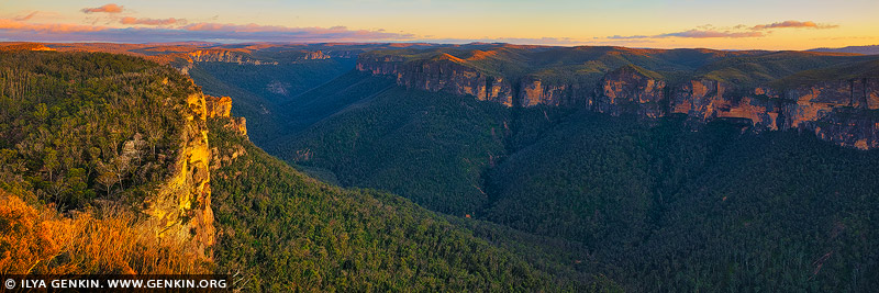
Grose Valley at Sunrise, Blackheath, Blue Mountains National Park, NSW, Australia.
Anvil Rock Lookout in the Blackheath area of the Blue Mountains is the place where visitors can enjoy incredible 360-degree Grose Valley views. Nearby Wind Eroded Cave is a must-visit too, a unique rock formation shaped like a wave-like overhang, created by wind erosion. Both of these fascinating sights can be accessed via two short walking tracks, with even more lookout points nearby to make a great day of it.

Stormy Evening at Narrow Neck Plateau, Katoomba, Blue Mountains National Park, NSW, Australia 24 Sep 2022 8:10 PM (2 years ago)
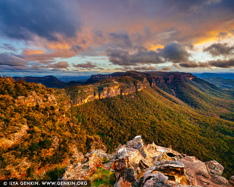
Stormy Evening at Narrow Neck Plateau, Katoomba, Blue Mountains National Park, NSW, Australia.
The Narrow Neck Plateau, an eroded remnant of a sandstone layer situated at an elevation of 1,000 metres (3,300 ft) above sea level that is part of the Blue Mountains Range which is a spur line off the Great Dividing Range, is situated immediately south-west of Katoomba in New South Wales, Australia, located within the Blue Mountains National Park. The neck separates the Jamison Valley (to the east) from the Megalong Valley (to the west). From Cliff Drive, Katoomba, the Narrow Neck is accessed via a dirt road called Glenraphael Drive suitable for most two-wheel drive vehicles, subject to good weather conditions, as far as a locked gate. It is a popular walking, bike riding and climbing location and offers several walking descent routes to the adjacent valleys. Beyond the gate is walking/bicycle access only for the general public. One of the most popular walks is the Golden Stairs, a rough descent of approximately 200 metres (660 ft) to join the Federal Pass. This opens up the Jamison Valley for popular day walks to sites such as Mount Solitary and the Ruined Castle. The neck juts southwards from Katoomba for a distance of some 10 kilometres (6.2 mi) and ends at Clear Hill, overlooking the Wild Dog Mountains. Castle Head promontory points towards the Ruined Castle, a small rock formation between Castle Head and Mount Solitary. Arguably one of the best views on the eastern seaboard of NSW is from Narrow Neck Fire Tower. On a day of high visibility it is possible to see from Mittagong in the south to Toronto in the north and a number of peak landforms in between. It also has excellent views back towards the escarpment at Katoomba.
%20above%20sea%20level%20that%20is%20part%20of%20the%20Blue%20Mountains%20Range%20which%20is%20a%20spur%20line%20off%20the%20Great%20Dividing%20Range,%20is%20situated%20immediately%20south-west%20of%20Katoomba%20in%20New%20South%20Wales,%20Australia,%20located%20within%20the%20Blue%20Mountains%20National%20Park.%20The%20neck%20separates%20the%20Jamison%20Valley%20(to%20the%20east)%20from%20the%20Megalong%20Valley%20(to%20the%20west).%20From%20Cliff%20Drive,%20Katoomba,%20the%20Narrow%20Neck%20is%20accessed%20via%20a%20dirt%20road%20called%20Glenraphael%20Drive%20suitable%20for%20most%20two-wheel%20drive%20vehicles,%20subject%20to%20good%20weather%20conditions,%20as%20far%20as%20a%20locked%20gate.%20It%20is%20a%20popular%20walking,%20bike%20riding%20and%20climbing%20location%20and%20offers%20several%20walking%20descent%20routes%20to%20the%20adjacent%20valleys.%20Beyond%20the%20gate%20is%20walking/bicycle%20access%20only%20for%20the%20general%20public.%20One%20of%20the%20most%20popular%20walks%20is%20the%20Golden%20Stairs,%20a%20rough%20descent%20of%20approximately%20200%20metres%20(660%20ft)%20to%20join%20the%20Federal%20Pass.%20This%20opens%20up%20the%20Jamison%20Valley%20for%20popular%20day%20walks%20to%20sites%20such%20as%20Mount%20Solitary%20and%20the%20Ruined%20Castle.%20The%20neck%20juts%20southwards%20from%20Katoomba%20for%20a%20distance%20of%20some%2010%20kilometres%20(6.2%20mi)%20and%20ends%20at%20Clear%20Hill,%20overlooking%20the%20Wild%20Dog%20Mountains.%20Castle%20Head%20promontory%20points%20towards%20the%20Ruined%20Castle,%20a%20small%20rock%20formation%20between%20Castle%20Head%20and%20Mount%20Solitary.%20Arguably%20one%20of%20the%20best%20views%20on%20the%20eastern%20seaboard%20of%20NSW%20is%20from%20Narrow%20Neck%20Fire%20Tower.%20On%20a%20day%20of%20high%20visibility%20it%20is%20possible%20to%20see%20from%20Mittagong%20in%20the%20south%20to%20Toronto%20in%20the%20north%20and%20a%20number%20of%20peak%20landforms%20in%20between.%20It%20also%20has%20excellent%20views%20back%20towards%20the%20escarpment%20at%20Katoomba.%22%20/%3E%3C/a%3E%3Cbr%20/%3E%0A%3Cb%3EStormy%20Evening%20at%20Narrow%20Neck%20Plateau,%20Katoomba,%20Blue%20Mountains%20National%20Park,%20NSW,%20Australia%3C/b%3E.%3Cbr%20/%3E%0AThe%20Narrow%20Neck%20Plateau,%20an%20eroded%20remnant%20of%20a%20sandstone%20layer%20situated%20at%20an%20elevation%20of%201,000%20metres%20(3,300%20ft)%20above%20sea%20level%20that%20is%20part%20of%20the%20Blue%20Mountains%20Range%20which%20is%20a%20spur%20line%20off%20the%20Great%20Dividing%20Range,%20is%20situated%20immediately%20south-west%20of%20Katoomba%20in%20New%20South%20Wales,%20Australia,%20located%20within%20the%20Blue%20Mountains%20National%20Park.%20The%20neck%20separates%20the%20Jamison%20Valley%20(to%20the%20east)%20from%20the%20Megalong%20Valley%20(to%20the%20west).%20From%20Cliff%20Drive,%20Katoomba,%20the%20Narrow%20Neck%20is%20accessed%20via%20a%20dirt%20road%20called%20Glenraphael%20Drive%20suitable%20for%20most%20two-wheel%20drive%20vehicles,%20subject%20to%20good%20weather%20conditions,%20as%20far%20as%20a%20locked%20gate.%20It%20is%20a%20popular%20walking,%20bike%20riding%20and%20climbing%20location%20and%20offers%20several%20walking%20descent%20routes%20to%20the%20adjacent%20valleys.%20Beyond%20the%20gate%20is%20walking/bicycle%20access%20only%20for%20the%20general%20public.%20One%20of%20the%20most%20popular%20walks%20is%20the%20Golden%20Stairs,%20a%20rough%20descent%20of%20approximately%20200%20metres%20(660%20ft)%20to%20join%20the%20Federal%20Pass.%20This%20opens%20up%20the%20Jamison%20Valley%20for%20popular%20day%20walks%20to%20sites%20such%20as%20Mount%20Solitary%20and%20the%20Ruined%20Castle.%20The%20neck%20juts%20southwards%20from%20Katoomba%20for%20a%20distance%20of%20some%2010%20kilometres%20(6.2%20mi)%20and%20ends%20at%20Clear%20Hill,%20overlooking%20the%20Wild%20Dog%20Mountains.%20Castle%20Head%20promontory%20points%20towards%20the%20Ruined%20Castle,%20a%20small%20rock%20formation%20between%20Castle%20Head%20and%20Mount%20Solitary.%20Arguably%20one%20of%20the%20best%20views%20on%20the%20eastern%20seaboard%20of%20NSW%20is%20from%20Narrow%20Neck%20Fire%20Tower.%20On%20a%20day%20of%20high%20visibility%20it%20is%20possible%20to%20see%20from%20Mittagong%20in%20the%20south%20to%20Toronto%20in%20the%20north%20and%20a%20number%20of%20peak%20landforms%20in%20between.%20It%20also%20has%20excellent%20views%20back%20towards%20the%20escarpment%20at%20Katoomba.)
Walls of Landslide Lookout, Mount Solitary and Jamison Valley at Sunset, Katoomba, Blue Mountains, NSW, Australia 24 Sep 2022 8:10 PM (2 years ago)
Walls of Landslide Lookout, Mount Solitary and Jamison Valley at Sunset, Katoomba, Blue Mountains, NSW, Australia.
Mount Solitary, a mountain that is part of the Blue Mountains Range, a spur off the Great Dividing Range, is situated within the Blue Mountains National Park, New South Wales, Australia. Mount Solitary is located approximately 100 kilometres (62 mi) west of Sydney, and a few kilometres south of Katoomba, the main town in the Blue Mountains. The local indigenous people called the mountain Korowal, meaning 'the strong one'. The origin of the contemporary name is obscure, but it may be based on the fact that Mount Solitary is the only mountain in the Jamison Valley. Mount Solitary is located in the middle of the Jamison Valley, one of the main valleys of the Blue Mountains region, immediately south of Katoomba. It is a long, low mountain of sandstone, stretching across the valley from west to east. Landslide Lookout is home to an interesting and debatable past as well as being home to 'never-ending' mountain and valley views as far as the naked eye can see. There are many boulders that cover a wide-range of the Lookout, cliff sides and lush vegetation. Landslide Lookout is one of those lookouts that make you feel insignificant standing next to the mighty and spectacular nature!
%20west%20of%20Sydney,%20and%20a%20few%20kilometres%20south%20of%20Katoomba,%20the%20main%20town%20in%20the%20Blue%20Mountains.%20The%20local%20indigenous%20people%20called%20the%20mountain%20Korowal,%20meaning%20'the%20strong%20one'.%20The%20origin%20of%20the%20contemporary%20name%20is%20obscure,%20but%20it%20may%20be%20based%20on%20the%20fact%20that%20Mount%20Solitary%20is%20the%20only%20mountain%20in%20the%20Jamison%20Valley.%20Mount%20Solitary%20is%20located%20in%20the%20middle%20of%20the%20Jamison%20Valley,%20one%20of%20the%20main%20valleys%20of%20the%20Blue%20Mountains%20region,%20immediately%20south%20of%20Katoomba.%20It%20is%20a%20long,%20low%20mountain%20of%20sandstone,%20stretching%20across%20the%20valley%20from%20west%20to%20east.%20Landslide%20Lookout%20is%20home%20to%20an%20interesting%20and%20debatable%20past%20as%20well%20as%20being%20home%20to%20'never-ending'%20mountain%20and%20valley%20views%20as%20far%20as%20the%20naked%20eye%20can%20see.%20There%20are%20many%20boulders%20that%20cover%20a%20wide-range%20of%20the%20Lookout,%20cliff%20sides%20and%20lush%20vegetation.%20Landslide%20Lookout%20is%20one%20of%20those%20lookouts%20that%20make%20you%20feel%20insignificant%20standing%20next%20to%20the%20mighty%20and%20spectacular%20nature!%22%20/%3E%3C/a%3E%3Cbr%20/%3E%0A%3Cb%3EWalls%20of%20Landslide%20Lookout,%20Mount%20Solitary%20and%20Jamison%20Valley%20at%20Sunset,%20Katoomba,%20Blue%20Mountains,%20NSW,%20Australia%3C/b%3E.%3Cbr%20/%3E%0AMount%20Solitary,%20a%20mountain%20that%20is%20part%20of%20the%20Blue%20Mountains%20Range,%20a%20spur%20off%20the%20Great%20Dividing%20Range,%20is%20situated%20within%20the%20Blue%20Mountains%20National%20Park,%20New%20South%20Wales,%20Australia.%20Mount%20Solitary%20is%20located%20approximately%20100%20kilometres%20(62%20mi)%20west%20of%20Sydney,%20and%20a%20few%20kilometres%20south%20of%20Katoomba,%20the%20main%20town%20in%20the%20Blue%20Mountains.%20The%20local%20indigenous%20people%20called%20the%20mountain%20Korowal,%20meaning%20'the%20strong%20one'.%20The%20origin%20of%20the%20contemporary%20name%20is%20obscure,%20but%20it%20may%20be%20based%20on%20the%20fact%20that%20Mount%20Solitary%20is%20the%20only%20mountain%20in%20the%20Jamison%20Valley.%20Mount%20Solitary%20is%20located%20in%20the%20middle%20of%20the%20Jamison%20Valley,%20one%20of%20the%20main%20valleys%20of%20the%20Blue%20Mountains%20region,%20immediately%20south%20of%20Katoomba.%20It%20is%20a%20long,%20low%20mountain%20of%20sandstone,%20stretching%20across%20the%20valley%20from%20west%20to%20east.%20Landslide%20Lookout%20is%20home%20to%20an%20interesting%20and%20debatable%20past%20as%20well%20as%20being%20home%20to%20'never-ending'%20mountain%20and%20valley%20views%20as%20far%20as%20the%20naked%20eye%20can%20see.%20There%20are%20many%20boulders%20that%20cover%20a%20wide-range%20of%20the%20Lookout,%20cliff%20sides%20and%20lush%20vegetation.%20Landslide%20Lookout%20is%20one%20of%20those%20lookouts%20that%20make%20you%20feel%20insignificant%20standing%20next%20to%20the%20mighty%20and%20spectacular%20nature!)
Sydney Harbour Bridge from Pylon Lookout, Sydney, NSW, Australia 20 Aug 2022 7:52 PM (2 years ago)
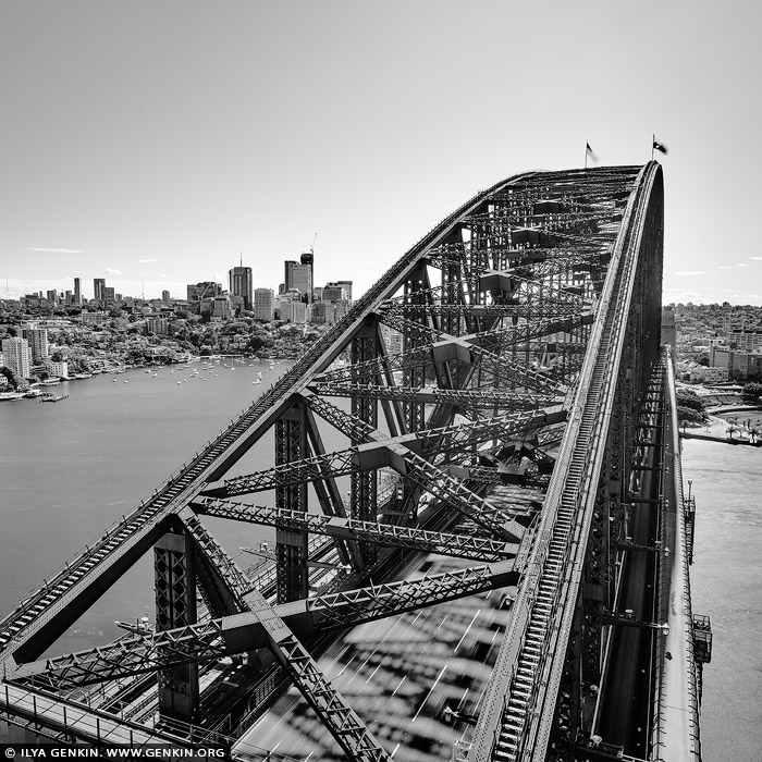
Sydney Harbour Bridge from Pylon Lookout, Sydney, NSW, Australia.
The Sydney Harbour Bridge Pylon Lookout is a must-see whilst in Sydney. Located on the south side of Sydney Harbour Bridge it provides three levels of exhibits and magnificent panoramic view of the City of Sydney, North Sydney, east towards the heads of Sydney Harbour, the Opera House, Circular Quay, Botanical Gardens and the surrounding areas. Goat Island and Fort Denison can also be seen. On a clear day you can see as far as the Blue Mountains.

Camp Cove Jetty, South Head, Watson Bay, Sydney, New South Wales (NSW), Australia 20 Aug 2022 7:51 PM (2 years ago)
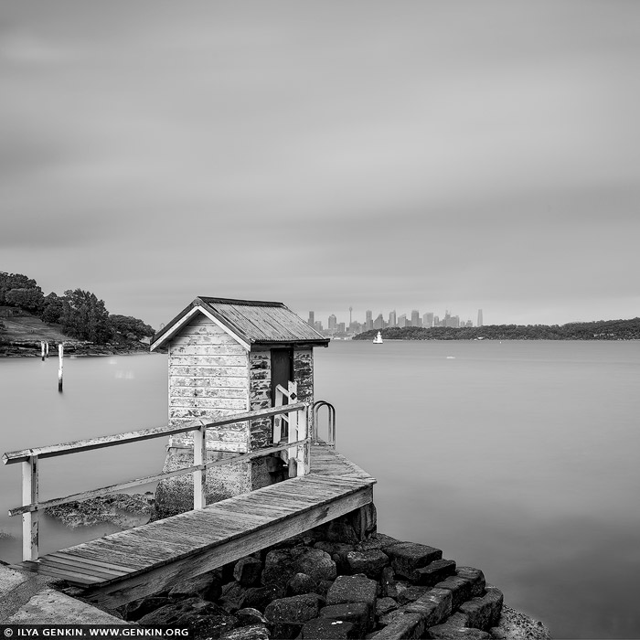
Camp Cove Jetty, South Head, Watson Bay, Sydney, New South Wales (NSW), Australia.
Just a short walk from Watsons Bay ferry wharf, wheelchair-accessible Camp Cove boasts millionaire views that are hard to miss. Nestled on the harbour side of South Head, this delightful beach is packed with fun options to keep the family smiling all day long. The kids will love swimming and snorkelling in the calm waters while you relax on the sandy beach. Unroll the picnic rug and enjoy a leisurely lunch while taking in the spectacular harbour views and city skyline. Round off a perfect day-trip with an ice cream or cool drink from the nearby kiosk. For the more adventurous, bring your kayak for a paddle or explore the underwater world while scuba diving. For a walk that takes in the unique history and breathtaking scenery of the southern area of Sydney Harbour National Park, South Head Heritage trail, starts at the northern end of the beach.
,%20Australia%26bodytext%3D%3Ca%20href%3D%22http://www.genkin.org/cgi-bin/photo.pl/portfolio/bw-sydney-in-square/sydney-in-square-0015%22%20title%3D%22Camp%20Cove%20Jetty,%20South%20Head,%20Watson%20Bay,%20Sydney,%20New%20South%20Wales%20(NSW),%20Australia%22%3E%3Cimg%20src%3D%22http://www.genkin.org/gallery/portfolio/bw-sydney-in-square/sydney-in-square-0015.jpg%22%20alt%3D%22portfolio%20stock%20photography%20%7C%20Camp%20Cove%20Jetty,%20South%20Head,%20Watson%20Bay,%20Sydney,%20New%20South%20Wales%20(NSW),%20Australia.%20Just%20a%20short%20walk%20from%20Watsons%20Bay%20ferry%20wharf,%20wheelchair-accessible%20Camp%20Cove%20boasts%20millionaire%20views%20that%20are%20hard%20to%20miss.%20Nestled%20on%20the%20harbour%20side%20of%20South%20Head,%20this%20delightful%20beach%20is%20packed%20with%20fun%20options%20to%20keep%20the%20family%20smiling%20all%20day%20long.%20The%20kids%20will%20love%20swimming%20and%20snorkelling%20in%20the%20calm%20waters%20while%20you%20relax%20on%20the%20sandy%20beach.%20Unroll%20the%20picnic%20rug%20and%20enjoy%20a%20leisurely%20lunch%20while%20taking%20in%20the%20spectacular%20harbour%20views%20and%20city%20skyline.%20Round%20off%20a%20perfect%20day-trip%20with%20an%20ice%20cream%20or%20cool%20drink%20from%20the%20nearby%20kiosk.%20For%20the%20more%20adventurous,%20bring%20your%20kayak%20for%20a%20paddle%20or%20explore%20the%20underwater%20world%20while%20scuba%20diving.%20For%20a%20walk%20that%20takes%20in%20the%20unique%20history%20and%20breathtaking%20scenery%20of%20the%20southern%20area%20of%20Sydney%20Harbour%20National%20Park,%20South%20Head%20Heritage%20trail,%20starts%20at%20the%20northern%20end%20of%20the%20beach.%22%20/%3E%3C/a%3E%3Cbr%20/%3E%0A%3Cb%3ECamp%20Cove%20Jetty,%20South%20Head,%20Watson%20Bay,%20Sydney,%20New%20South%20Wales%20(NSW),%20Australia%3C/b%3E.%3Cbr%20/%3E%0AJust%20a%20short%20walk%20from%20Watsons%20Bay%20ferry%20wharf,%20wheelchair-accessible%20Camp%20Cove%20boasts%20millionaire%20views%20that%20are%20hard%20to%20miss.%20Nestled%20on%20the%20harbour%20side%20of%20South%20Head,%20this%20delightful%20beach%20is%20packed%20with%20fun%20options%20to%20keep%20the%20family%20smiling%20all%20day%20long.%20The%20kids%20will%20love%20swimming%20and%20snorkelling%20in%20the%20calm%20waters%20while%20you%20relax%20on%20the%20sandy%20beach.%20Unroll%20the%20picnic%20rug%20and%20enjoy%20a%20leisurely%20lunch%20while%20taking%20in%20the%20spectacular%20harbour%20views%20and%20city%20skyline.%20Round%20off%20a%20perfect%20day-trip%20with%20an%20ice%20cream%20or%20cool%20drink%20from%20the%20nearby%20kiosk.%20For%20the%20more%20adventurous,%20bring%20your%20kayak%20for%20a%20paddle%20or%20explore%20the%20underwater%20world%20while%20scuba%20diving.%20For%20a%20walk%20that%20takes%20in%20the%20unique%20history%20and%20breathtaking%20scenery%20of%20the%20southern%20area%20of%20Sydney%20Harbour%20National%20Park,%20South%20Head%20Heritage%20trail,%20starts%20at%20the%20northern%20end%20of%20the%20beach.)
Hornby Lighthouse, South Head, Watson Bay, Sydney, New South Wales (NSW), Australia 20 Aug 2022 7:51 PM (2 years ago)
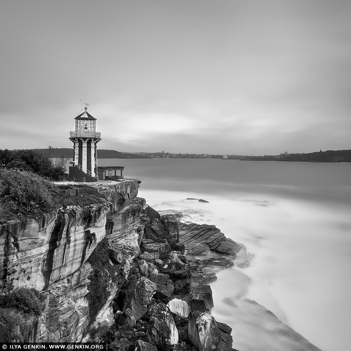
Hornby Lighthouse, South Head, Watson Bay, Sydney, New South Wales (NSW), Australia.
Hornby Lighthouse stands tall at South Head, near Watsons Bay in Sydney Harbour National Park. The iconic red and white striped tower is surrounded by magnificent views: Sydney Harbour to the west, Middle Head and North Head to the north, and the expansive Pacific Ocean to the east. The lighthouse was built in 1858 following the wrecking of the Dunbar at the foot of South Head. Designed by colonial architect Alexander Dawson, Hornby Lighthouse was the third lighthouse to be built in NSW. Hornby Lighthouse is accessible via the South Head heritage trail – an easy walk that leaves from Camp Cove at Watsons Bay, taking you past historic gun emplacements before reaching Hornby Lighthouse.
,%20Australia%26bodytext%3D%3Ca%20href%3D%22http://www.genkin.org/cgi-bin/photo.pl/portfolio/bw-sydney-in-square/sydney-in-square-0014%22%20title%3D%22Hornby%20Lighthouse,%20South%20Head,%20Watson%20Bay,%20Sydney,%20New%20South%20Wales%20(NSW),%20Australia%22%3E%3Cimg%20src%3D%22http://www.genkin.org/gallery/portfolio/bw-sydney-in-square/sydney-in-square-0014.jpg%22%20alt%3D%22portfolio%20stock%20photography%20%7C%20Hornby%20Lighthouse,%20South%20Head,%20Watson%20Bay,%20Sydney,%20New%20South%20Wales%20(NSW),%20Australia.%20Hornby%20Lighthouse%20stands%20tall%20at%20South%20Head,%20near%20Watsons%20Bay%20in%20Sydney%20Harbour%20National%20Park.%20The%20iconic%20red%20and%20white%20striped%20tower%20is%20surrounded%20by%20magnificent%20views:%20Sydney%20Harbour%20to%20the%20west,%20Middle%20Head%20and%20North%20Head%20to%20the%20north,%20and%20the%20expansive%20Pacific%20Ocean%20to%20the%20east.%20The%20lighthouse%20was%20built%20in%201858%20following%20the%20wrecking%20of%20the%20Dunbar%20at%20the%20foot%20of%20South%20Head.%20Designed%20by%20colonial%20architect%20Alexander%20Dawson,%20Hornby%20Lighthouse%20was%20the%20third%20lighthouse%20to%20be%20built%20in%20NSW.%20Hornby%20Lighthouse%20is%20accessible%20via%20the%20South%20Head%20heritage%20trail%20%C3%A2%E2%82%AC%E2%80%9C%20an%20easy%20walk%20that%20leaves%20from%20Camp%20Cove%20at%20Watsons%20Bay,%20taking%20you%20past%20historic%20gun%20emplacements%20before%20reaching%20Hornby%20Lighthouse.%22%20/%3E%3C/a%3E%3Cbr%20/%3E%0A%3Cb%3EHornby%20Lighthouse,%20South%20Head,%20Watson%20Bay,%20Sydney,%20New%20South%20Wales%20(NSW),%20Australia%3C/b%3E.%3Cbr%20/%3E%0AHornby%20Lighthouse%20stands%20tall%20at%20South%20Head,%20near%20Watsons%20Bay%20in%20Sydney%20Harbour%20National%20Park.%20The%20iconic%20red%20and%20white%20striped%20tower%20is%20surrounded%20by%20magnificent%20views:%20Sydney%20Harbour%20to%20the%20west,%20Middle%20Head%20and%20North%20Head%20to%20the%20north,%20and%20the%20expansive%20Pacific%20Ocean%20to%20the%20east.%20The%20lighthouse%20was%20built%20in%201858%20following%20the%20wrecking%20of%20the%20Dunbar%20at%20the%20foot%20of%20South%20Head.%20Designed%20by%20colonial%20architect%20Alexander%20Dawson,%20Hornby%20Lighthouse%20was%20the%20third%20lighthouse%20to%20be%20built%20in%20NSW.%20Hornby%20Lighthouse%20is%20accessible%20via%20the%20South%20Head%20heritage%20trail%20%C3%A2%E2%82%AC%E2%80%9C%20an%20easy%20walk%20that%20leaves%20from%20Camp%20Cove%20at%20Watsons%20Bay,%20taking%20you%20past%20historic%20gun%20emplacements%20before%20reaching%20Hornby%20Lighthouse.)
Autumn Avenue in Mount Wilson, Blue Mountains National Park, NSW, Australia 20 May 2022 9:54 PM (2 years ago)
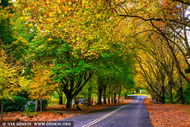
Autumn Avenue in Mount Wilson, Blue Mountains National Park, NSW, Australia.
Mount Wilson in Blue Mountains National Park, NSW, Australia is famous for its magnificent cool climate exotic gardens. Many gardens are open all year round but Spring and Autumn are the most popular seasons when the gardens are at their most colourful. Even just streets in Mt Wilson are very beautiful. Of particular note are Church Avenue, Queen's Avenue and The Avenue with their rows of plane trees, limes, elms, beeches, liquidambars and pink cherries.Mount Wilson holds an annual Autumn Garden Festival during April and May each year.

Autumn Colours in Blackheath, Blue Mountains National Park, NSW, Australia 20 May 2022 9:53 PM (2 years ago)
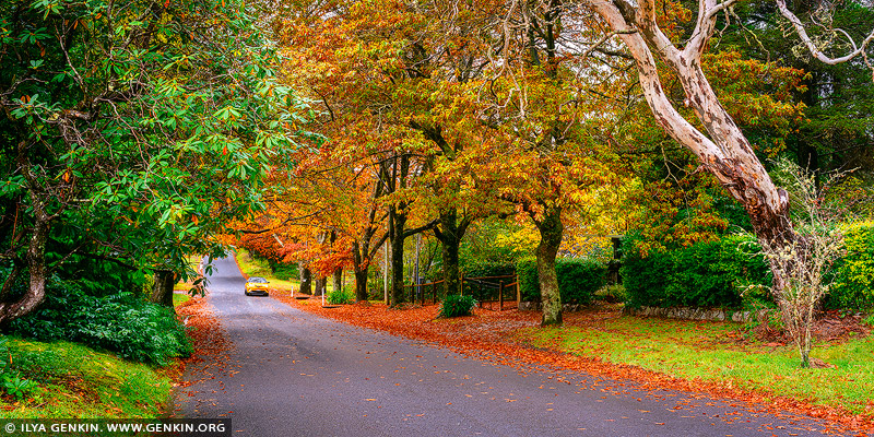
Autumn Colours in Blackheath, Blue Mountains National Park, NSW, Australia.
A beautiful road in Blackheath in Blue Mountains, NSW, Australia dressed in stunning autumn colours.

Colourful Autumn in Blackheath, Blue Mountains National Park, NSW, Australia 20 May 2022 9:53 PM (2 years ago)
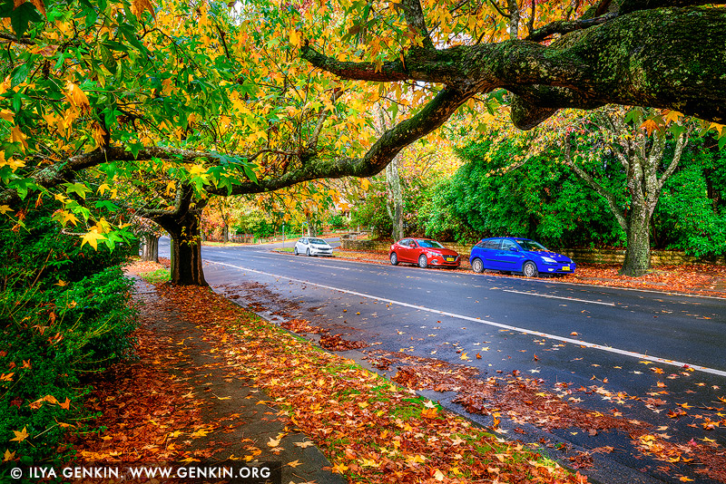
Colourful Autumn in Blackheath, Blue Mountains National Park, NSW, Australia.
When autumn arrives the deciduous trees and shrubs in Blackheath in Blue Mountains create a brilliant display worth travelling.

Parliament House at Sunset, Capital Hill, Canberra, ACT, Australia 20 May 2022 9:07 PM (2 years ago)
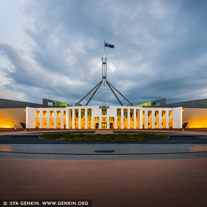
Parliament House at Sunset, Capital Hill, Canberra, ACT, Australia.
Parliament House, also referred to as Capital Hill or simply Parliament, is the meeting place of the Parliament of Australia, and the seat of the legislative branch of the Australian Government. Located in Canberra, the Parliament building is situated on the southern apex of the Parliamentary Triangle atop Capital Hill, at the meeting point of Commonwealth, Adelaide, Canberra and Kings Avenue enclosed by the State Circle. Parliament House was designed by Mitchell-Giurgola & Thorp Architects and it was opened on 9 May 1988 by Elizabeth II, Queen of Australia. The principal design of the structure is based on the shape of two boomerangs and is topped by an 81-metre (266 ft) flagpole. The flag above Parliament House is one of the biggest in Australia, measuring 12.8 metres by 6.4 metres.
%20flagpole.%20The%20flag%20above%20Parliament%20House%20is%20one%20of%20the%20biggest%20in%20Australia,%20measuring%2012.8%20metres%20by%206.4%20metres.%22%20/%3E%3C/a%3E%3Cbr%20/%3E%0A%3Cb%3EParliament%20House%20at%20Sunset,%20Capital%20Hill,%20Canberra,%20ACT,%20Australia%3C/b%3E.%3Cbr%20/%3E%0AParliament%20House,%20also%20referred%20to%20as%20Capital%20Hill%20or%20simply%20Parliament,%20is%20the%20meeting%20place%20of%20the%20Parliament%20of%20Australia,%20and%20the%20seat%20of%20the%20legislative%20branch%20of%20the%20Australian%20Government.%20Located%20in%20Canberra,%20the%20Parliament%20building%20is%20situated%20on%20the%20southern%20apex%20of%20the%20Parliamentary%20Triangle%20atop%20Capital%20Hill,%20at%20the%20meeting%20point%20of%20Commonwealth,%20Adelaide,%20Canberra%20and%20Kings%20Avenue%20enclosed%20by%20the%20State%20Circle.%20Parliament%20House%20was%20designed%20by%20Mitchell-Giurgola%20%26%20Thorp%20Architects%20and%20it%20was%20opened%20on%209%20May%201988%20by%20Elizabeth%20II,%20Queen%20of%20Australia.%20The%20principal%20design%20of%20the%20structure%20is%20based%20on%20the%20shape%20of%20two%20boomerangs%20and%20is%20topped%20by%20an%2081-metre%20(266%20ft)%20flagpole.%20The%20flag%20above%20Parliament%20House%20is%20one%20of%20the%20biggest%20in%20Australia,%20measuring%2012.8%20metres%20by%206.4%20metres.)
Sunset over Black Mountain and Telstra Tower, Canberra, ACT, Australia 20 May 2022 9:06 PM (2 years ago)
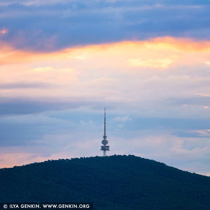
Sunset over Black Mountain and Telstra Tower, Canberra, ACT, Australia.
Vivid Sunset over the Black Mountain and Telstra Tower at Sunset in Canberra, ACT, Australia.

Commonwealth Bridge at Sunrise, Canberra, ACT, Australia 20 May 2022 9:06 PM (2 years ago)
Commonwealth Bridge at Sunrise, Canberra, ACT, Australia.
The Bridge is one of two major bridges crossing Lake Burley Griffin and is a critical component of the transport network of Canberra and the Australian Capital Territory overall. The Bridge also has considerable cultural and heritage value. The Bridge was built in the early 1960s. Since its opening, patronage on the Bridge has grown substantially. Current traffic on the Bridge makes it one of the busiest transport assets in Canberra.

Black Mountain and Telstra Tower at Sunset, Canberra, ACT, Australia 20 May 2022 9:05 PM (2 years ago)
Black Mountain and Telstra Tower at Sunset, Canberra, ACT, Australia.
Panoramic image of Black Mountain and Telstra Tower at Sunset in Canberra, ACT, Australia.

Sunrise at North Curl Curl Beach, Sydney, NSW, Australia 29 Dec 2021 3:02 PM (3 years ago)
Sunrise at North Curl Curl Beach, Sydney, NSW, Australia.
Beautiful sunrise at North Curl Curl Beach in Sydney, NSW, Australia. At North Curl Curl an obelisk was erected in memory of 10 soldiers from the district who died in service or were killed in action during World War One. It was built of concrete in 1917, and stands on a large rock base, overlooking the spot where these men used to spend their weekends.

Stormy Sunrise at North Curl Curl Beach, Sydney, NSW, Australia 29 Dec 2021 3:01 PM (3 years ago)
Stormy Sunrise at North Curl Curl Beach, Sydney, NSW, Australia.
Beautiful stormy sunrise at North Curl Curl Beach in Sydney, NSW, Australia. Visitors have stunning views of the Curl Curl Beach and the ocean. At North Curl Curl an obelisk was erected in memory of 10 soldiers from the district who died in service or were killed in action during World War One. It was built of concrete in 1917, and stands on a large rock base, overlooking the spot where these men used to spend their weekends.

Lake Burley Griffin with Commonwealth Avenue Bridge and Telstra Tower, Canberra, ACT, Australia 4 Apr 2021 5:14 PM (4 years ago)
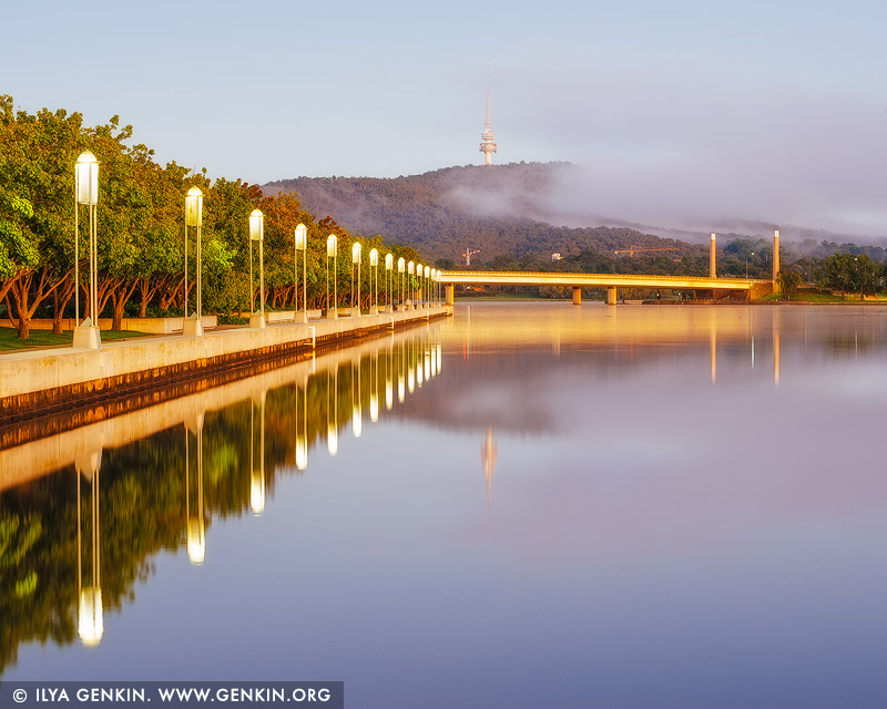
Lake Burley Griffin with Commonwealth Avenue Bridge and Telstra Tower, Canberra, ACT, Australia.
Lake Burley Griffin with Commonwealth Avenue Bridge and Telstra Tower early in the morning in Canberra, ACT, Australia.

Queen Elizabeth Terrace, Lake Burley Griffin and High Court of Australia in the Morning, Canberra, ACT, Australia 4 Apr 2021 5:14 PM (4 years ago)
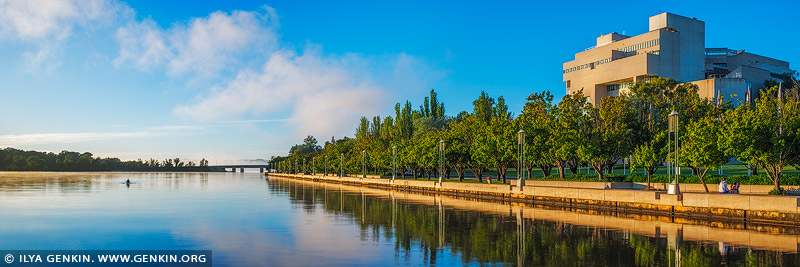
Queen Elizabeth Terrace, Lake Burley Griffin and High Court of Australia in the Morning, Canberra, ACT, Australia.
Panoramic image of Queen Elizabeth Terrace, Lake Burley Griffin and High Court of Australia early in the Morning.

Queen Elizabeth Terrace and Lake Burley Griffin at Sunrise, Canberra, ACT, Australia 4 Apr 2021 5:13 PM (4 years ago)

Queen Elizabeth Terrace and Lake Burley Griffin at Sunrise, Canberra, ACT, Australia.
Panoramic image of first morning light at Queen Elizabeth Terrace, Lake Burley Griffin, Commonwealth Avenue Bridge and Telstra Tower in Canberra, ACT, Australia.

Lake Burley Griffin with Commonwealth Avenue Bridge and Telstra Tower, Canberra, ACT, Australia 4 Apr 2021 5:13 PM (4 years ago)
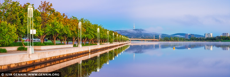
Lake Burley Griffin with Commonwealth Avenue Bridge and Telstra Tower, Canberra, ACT, Australia.
Lake Burley Griffin with Commonwealth Avenue Bridge and Telstra Tower early in the morning in Canberra, ACT, Australia.

Sydney Harbour Bridge and Opera House with Milky Way Rising Above, A View from Blues Point Reserve, Sydney, New South Wales (NSW), Australia 26 Feb 2021 9:59 PM (4 years ago)
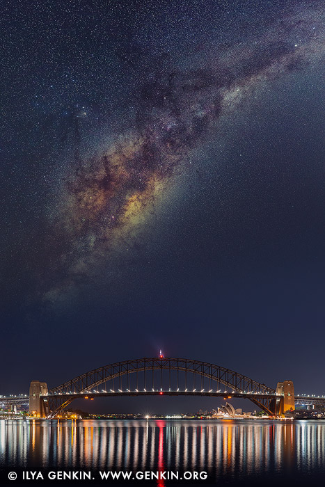
Sydney Harbour Bridge and Opera House with Milky Way Rising Above, A View from Blues Point Reserve, Sydney, New South Wales (NSW), Australia.
Milky Way rising above Sydney Harbour Bridge and Opera House in Sydney, NSW, Australia.
,%20Australia%26bodytext%3D%3Ca%20href%3D%22http://www.genkin.org/cgi-bin/photo.pl/australia/sydney/hb/au-sydney-harbour-bridge-0052%22%20title%3D%22Sydney%20Harbour%20Bridge%20and%20Opera%20House%20with%20Milky%20Way%20Rising%20Above,%20A%20View%20from%20Blues%20Point%20Reserve,%20Sydney,%20New%20South%20Wales%20(NSW),%20Australia%22%3E%3Cimg%20src%3D%22http://www.genkin.org/gallery/australia/sydney/hb/au-sydney-harbour-bridge-0052.jpg%22%20alt%3D%22australia%20stock%20photography%20%7C%20Sydney%20Harbour%20Bridge%20and%20Opera%20House%20with%20Milky%20Way%20Rising%20Above,%20A%20View%20from%20Blues%20Point%20Reserve,%20Sydney,%20New%20South%20Wales%20(NSW),%20Australia.%20Milky%20Way%20rising%20above%20Sydney%20Harbour%20Bridge%20and%20Opera%20House%20in%20Sydney,%20NSW,%20Australia.%22%20/%3E%3C/a%3E%3Cbr%20/%3E%0A%3Cb%3ESydney%20Harbour%20Bridge%20and%20Opera%20House%20with%20Milky%20Way%20Rising%20Above,%20A%20View%20from%20Blues%20Point%20Reserve,%20Sydney,%20New%20South%20Wales%20(NSW),%20Australia%3C/b%3E.%3Cbr%20/%3E%0AMilky%20Way%20rising%20above%20Sydney%20Harbour%20Bridge%20and%20Opera%20House%20in%20Sydney,%20NSW,%20Australia.)
The Three Sisters at Dramatic Sunrise, Echo Point, Katoomba, Blue Mountains, NSW, Australia 26 Feb 2021 9:59 PM (4 years ago)
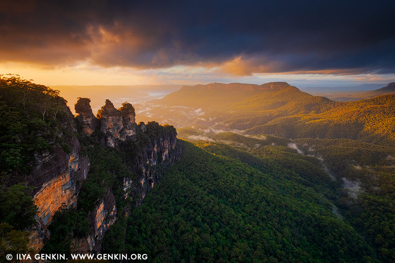
The Three Sisters at Dramatic Sunrise, Echo Point, Katoomba, Blue Mountains, NSW, Australia.
The Three Sisters are an icon of the Blue Mountains and NSW. These three pillars can be seen from the viewing platform at Echo Point in Katoomba, Blue Mountains, NSW, Australia. There is a fascinating Aboriginal dream-time legend that explains the story of the sisters and how they got there: The story tells of three sisters who were part of the Katoomba tribe who lived in the Jamison Valley. The three young women, Meehni, Wimblah and Gunnedoo had fallen in love with three boys (who were also brothers) from the Nepean tribe. However they weren't able to marry because of tribal law. The brothers upset by this decided to capture the three sisters, which started a battle between the two tribes. A witchdoctor from the Katoomba tribe took it upon himself to protect the sisters from harm, but turning them into stone for protection. He was killed during the battle so he was unable to turn them back to flesh like he planned to, after the battle was over. The sisters are still beautiful in their rock formation and remain there as a reminder of the battle that took place between the two tribes.
%20from%20the%20Nepean%20tribe.%20However%20they%20weren't%20able%20to%20marry%20because%20of%20tribal%20law.%20The%20brothers%20upset%20by%20this%20decided%20to%20capture%20the%20three%20sisters,%20which%20started%20a%20battle%20between%20the%20two%20tribes.%20A%20witchdoctor%20from%20the%20Katoomba%20tribe%20took%20it%20upon%20himself%20to%20protect%20the%20sisters%20from%20harm,%20but%20turning%20them%20into%20stone%20for%20protection.%20He%20was%20killed%20during%20the%20battle%20so%20he%20was%20unable%20to%20turn%20them%20back%20to%20flesh%20like%20he%20planned%20to,%20after%20the%20battle%20was%20over.%20The%20sisters%20are%20still%20beautiful%20in%20their%20rock%20formation%20and%20remain%20there%20as%20a%20reminder%20of%20the%20battle%20that%20took%20place%20between%20the%20two%20tribes.%22%20/%3E%3C/a%3E%3Cbr%20/%3E%0A%3Cb%3EThe%20Three%20Sisters%20at%20Dramatic%20Sunrise,%20Echo%20Point,%20Katoomba,%20Blue%20Mountains,%20NSW,%20Australia%3C/b%3E.%3Cbr%20/%3E%0AThe%20Three%20Sisters%20are%20an%20icon%20of%20the%20Blue%20Mountains%20and%20NSW.%20These%20three%20pillars%20can%20be%20seen%20from%20the%20viewing%20platform%20at%20Echo%20Point%20in%20Katoomba,%20Blue%20Mountains,%20NSW,%20Australia.%20There%20is%20a%20fascinating%20Aboriginal%20dream-time%20legend%20that%20explains%20the%20story%20of%20the%20sisters%20and%20how%20they%20got%20there:%20The%20story%20tells%20of%20three%20sisters%20who%20were%20part%20of%20the%20Katoomba%20tribe%20who%20lived%20in%20the%20Jamison%20Valley.%20The%20three%20young%20women,%20Meehni,%20Wimblah%20and%20Gunnedoo%20had%20fallen%20in%20love%20with%20three%20boys%20(who%20were%20also%20brothers)%20from%20the%20Nepean%20tribe.%20However%20they%20weren't%20able%20to%20marry%20because%20of%20tribal%20law.%20The%20brothers%20upset%20by%20this%20decided%20to%20capture%20the%20three%20sisters,%20which%20started%20a%20battle%20between%20the%20two%20tribes.%20A%20witchdoctor%20from%20the%20Katoomba%20tribe%20took%20it%20upon%20himself%20to%20protect%20the%20sisters%20from%20harm,%20but%20turning%20them%20into%20stone%20for%20protection.%20He%20was%20killed%20during%20the%20battle%20so%20he%20was%20unable%20to%20turn%20them%20back%20to%20flesh%20like%20he%20planned%20to,%20after%20the%20battle%20was%20over.%20The%20sisters%20are%20still%20beautiful%20in%20their%20rock%20formation%20and%20remain%20there%20as%20a%20reminder%20of%20the%20battle%20that%20took%20place%20between%20the%20two%20tribes.)
Stormy Sunset at Palm Beach, Panoramic View from Barrenjoey Lookout, Sydney, NSW, Australia 26 Feb 2021 9:58 PM (4 years ago)
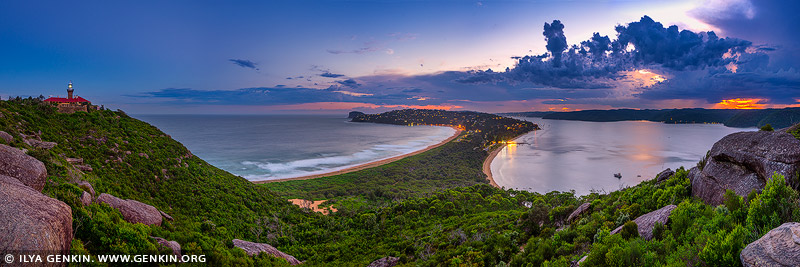
Stormy Sunset at Palm Beach, Panoramic View from Barrenjoey Lookout, Sydney, NSW, Australia.
Barrenjoey Headland Walk is a fantastic walk for those wanting a great walk on Sydney's northern beaches. Barrenjoey Lookout along this track offers fantastic views of the central coast, Palm Beach and the South Pacific Ocean.

Vivid Sunrise at Crown Casino, Barangaroo and Darling Harbour, Sydney, New South Wales, Australia 24 Jan 2021 5:06 PM (4 years ago)
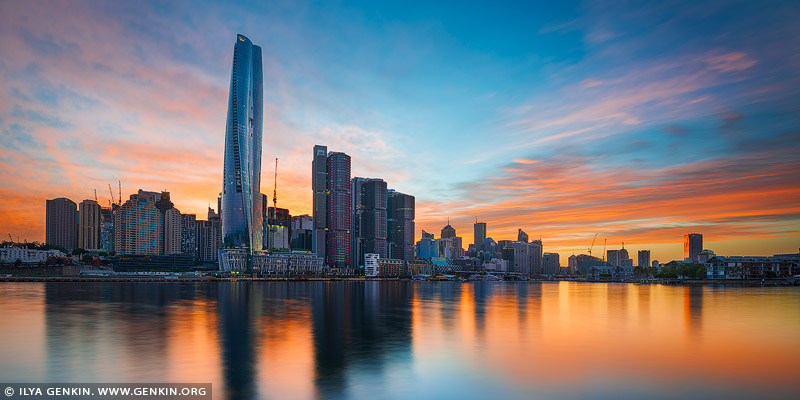
Vivid Sunrise at Crown Casino, Barangaroo and Darling Harbour, Sydney, New South Wales, Australia.
Crown Towers Sydney is so-called 'six star' hotel with the claim it is Australia's 'most luxurious'. The hotel forms part of Crown Sydney's $2.2 billion Barangaroo complex, with several restaurants, bars and luxury retail outlets also opening with the hotel. At 275 metres high, Crown Towers is the tallest hotel in Sydney, with 349 guest rooms including 22 luxury 'villas'. There are 14 restaurants and bars on site, along with a spa and pool. There's also a free observation deck open to the public, 250 metres up. The 88-storey building was designed by Britain's Chris Wilkinson, whose firm Wilkinson Eyre was also responsible for Singapore's iconic Gardens by the Bay.
