Snake River Fund View RSS

The Snake River Fund's mission is to promote stewardship of and recreational access to the Snake River watershed in Wyoming, with an emphasis on partnerships, education and public outreach.
Hide details

Podcast player

This player allows you to view entire playlists of podcasts as opposed to single feeds


New Film Explores Attributes & Challenges Facing Snake River 21 Mar 8:03 AM (27 days ago)

Frog Water Productions’ latest film – Iconic Rises – highlights the reverence our local fly fishing community has for our native Snake River fine spotted cutthroat and Wyoming Snake River watershed. It also deep dives into the threats the fishery faces from climate change, congestion, water usage within the upper Snake system, and how to more equitably meet the needs of the ecosystem and those who cherish it.

Iconic Rises explores these challenges through discussions with numerous stakeholders, including nonprofits, anglers, guides, and outfitters. Perhaps the most critical issues examined in this film are the steep winter-flow drawdown event on the Snake in 2022 and the proposal by the Bureau of Reclamation to draw down flows from Jackson Lake Dam to 50cfs in the spring of 2023. Iconic Rises illustrates how the partnership of numerous stake holders – including Snake River Fund, Trout Unlimited, Wyoming Game and Fish, Friends of the Bridger-Teton, Grand Teton National Park, and a community of full of anglers and other river users – came together to hold the levers of power and influence to account for their actions, and even change course.

Iconic Rises provides a large and inspiring ray hope – hope that arises when voices from the community unite with regional and national parties to solve critical problems.

An official selection of the 2025 Fly Fishing Film Tour, this is easily one of the most important conservation productions of the year. You can view the trailer HERE. The full-length film will be available in November.

The post New Film Explores Attributes & Challenges Facing Snake River appeared first on Snake River Fund.


Add post to Blinklist Add post to Blogmarks Add post to del.icio.us Digg this! Add post to My Web 2.0 Add post to Newsvine Add post to Reddit Add post to Simpy Who's linking to this post?

Join Snake River Fund’s Fight to Protect Teton County Public Lands 20 Mar 2:40 PM (28 days ago)

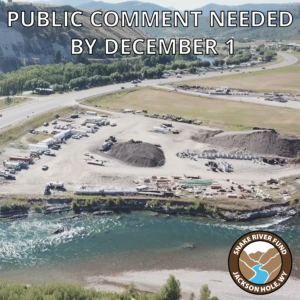
A decade’s long effort to transfer BLM lands into Teton County hands is at a precarious tipping point and, now, access to some of our community’s most precious riparian public lands is under threat. BLM Parcel 9/10 is 350+ acres of public lands sitting just North of Emily’s Pond. You may know it best for the nearly 3 linear miles of levee top access. But the parcel is also home to dramatic cottonwood galleries to the east and exceptional river access and angling opportunities to the west.

The adjacent landowner, 4W LLC., is proposing to purchase the 23 northern-most acres of Parcel 9/10 in return for granting Teton County an easement on the southern end of their property which may (or may not) allow for a more functional pathway along Highway 22. Essentially, 4W is trying to force our community to choose between preservation of public land access and a functional pathway. We deserve to have both and our County Commissioners need to hear that from you!

The Commissioners have asked to hear what matters to the public by April 28th, 2025. Please take a second to download the Form Letter below. It can be personalized and emailed to our County Commissioners at commissioners@tetoncountywy.gov. You’ll also see links to download supplemental materials which expand on the recent history of BLM Parcel 9/10 and expand upon the larger land transfer process.

Thank you for your support. Please don’t hesitate to reach out to Orion with questions: orion@snakeriverfund.org; (307)734-6773.

Click Here to Download Form Letter

Click Here to Download Supplemental Materials on Parcel 9/10

Click Here to Download Supplemental Materials on the greater Land Transfer Process

BLM Parcel 9/10 is 350+ acres of riparian public land situated northeast of the Wilson Snake River Bridge.

Artwork by: Diane Benefiel

The post Join Snake River Fund’s Fight to Protect Teton County Public Lands appeared first on Snake River Fund.

Add post to Blinklist Add post to Blogmarks Add post to del.icio.us Digg this! Add post to My Web 2.0 Add post to Newsvine Add post to Reddit Add post to Simpy Who's linking to this post?

Snake River Fund Realizes Major Win for Public Lands 12 Dec 2023 12:50 PM (last year)

December, 2023 – The Snake River Fund has been successful in their request that approximately 2000 linear feet of public lands be opened for the enjoyment of all this winter. BLM Parcel 9/10 is approximately 320 acres of public land situated just to the north of Emily’s Pond in Teton County. If you’ve ever enjoyed a stroll on the northeast levee and adjacent Cottonwood galleries by the Wilson Bridge, you’ve enjoyed Parcel 9/10. For years, the northern extent of the parcel has been behind a locked gate, restricting access to some of the most scenic and peaceful portions of Parcel 9/10. Now, on December 11, 2023, the Board of Teton County Commissioners have voted to unlock and open the gate. The Snake River Fund is proud to have been instrumental in realizing this outcome. The opening of the north gate is a true win for all: Nordic skiers; bikers; dog walkers; anglers; hunters; river runners; and all other river-sider recreationalists. The Snake River Fund remains committed to promoting year round access to and stewardship of the Snake River watershed. Please be sure to respect private property when enjoying your public lands.

The post Snake River Fund Realizes Major Win for Public Lands appeared first on Snake River Fund.

Add post to Blinklist Add post to Blogmarks Add post to del.icio.us Digg this! Add post to My Web 2.0 Add post to Newsvine Add post to Reddit Add post to Simpy Who's linking to this post?

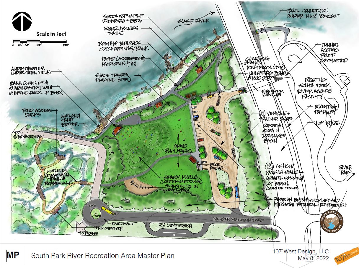
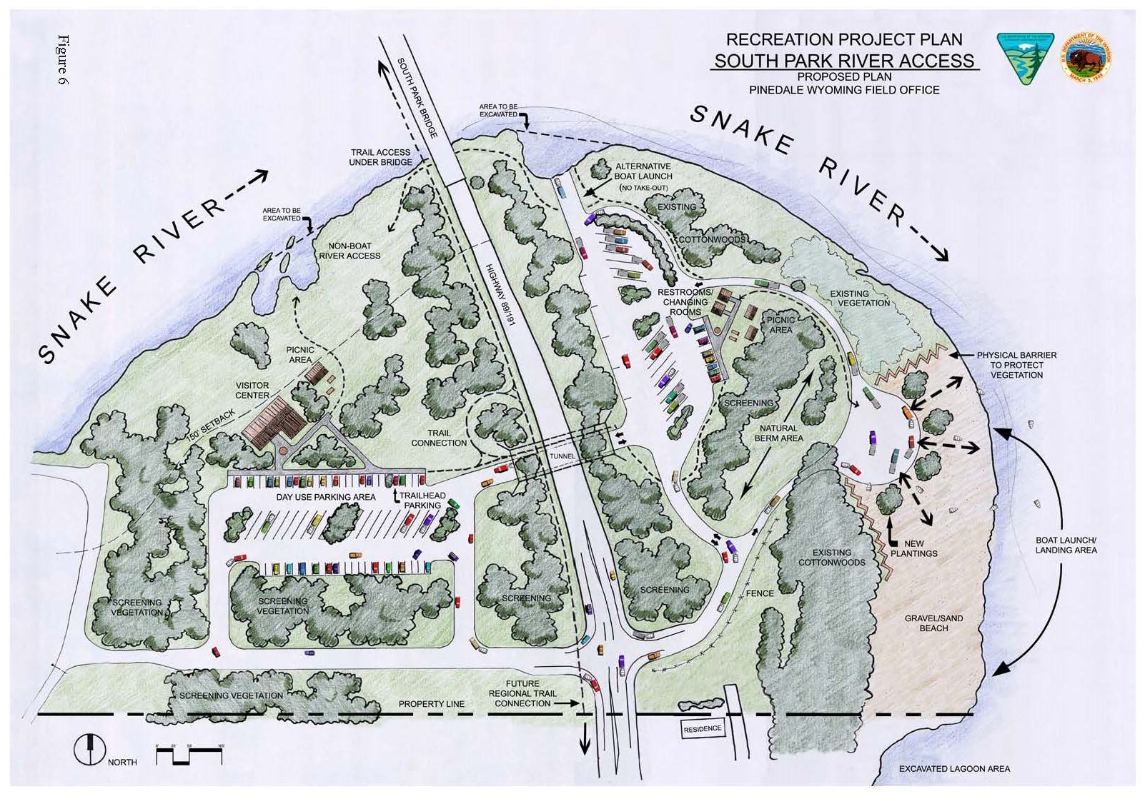
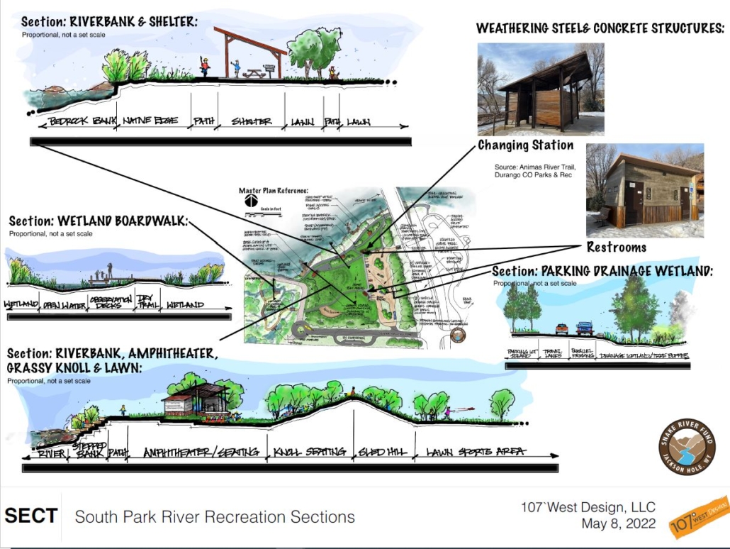
Let’s Make The Next River Park A Reality 16 Nov 2023 1:39 PM (last year)

Write your County Commissioners

click here to download our form letter

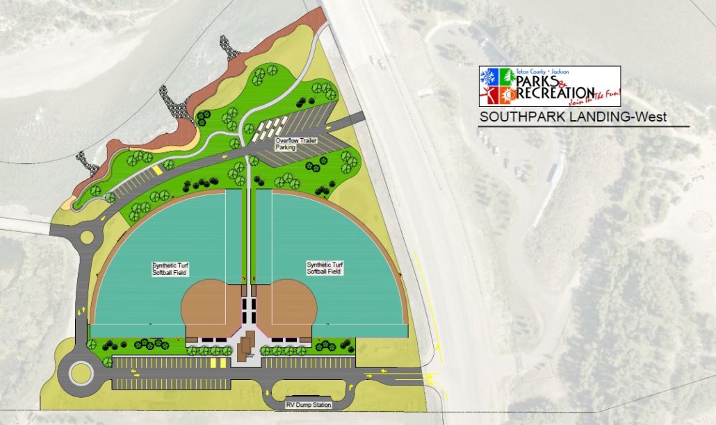
Development of South Park West is in its early stages.  Over the past decade and a half, Snake River Fund has played an integral role in the ownership transfer process of this parcel from Bureau of Land Management to Teton County.  Through much of that process, we have promoted a vision supported by so many in the community – a river-side park along the banks of the Snake with ample parking, greenspaces, group shelters, and ecologically friendly access to the river and adjacent wetlands.  With a direct connection to the popular South Park Boat Ramp to the east, and a lack of passive, riverside spaces in our community, such a vision makes sense.

There has been discussion over the past few weeks of plans for South Park West that diverge drastically from the original community-shared river park concept. Teton County is now considering the possibility of installing two artificially turfed and lighted softball fields on this parcel. This vision runs counter to community desires and compromises years of consensus vision.  Such development will encroach upon intended greenspace, limited access to the river and wetlands, increase travel time for athletes intending to use these fields, increase traffic south of town for commuters, and relegate the vast majority of South Park West to one-dimensional use.

As this process continues, the Snake River Fund and our supporters will urge Teton County to honor the work that has been done over the past decade by the community and various stakeholders to responsibly develop a riverside park.  While softball fields have a place in Jackson Hole, that place should not be a part of South Park West.

To better understand the planning, decision making process, and community involvement over the past two-plus decades, please review this timeline –

Timeline for South Park Development: 1999-present
1999 – BLM initiates Snake River Resource Management Plan development process.
2004 – Record of Decision issued by BLM to dispose Snake River corridor parcels from their administration. Find the full Record of Decision here.
2004 – The BLM publishes the Recreation Project Plan for South Park. This plan includes widely lauded concepts for a passive park on South Park West seen below.
2008 – Snake River Corridor Management/Ownership Transfer Plan issued, identifying Parcel 26, including South Park West, as a Teton County boat ramp and riverside park. The purpose of this plan is to provide the Snake River Task Force with the information and tools to initiate the transfer of BLM parcels to other entities, and a framework for the long-term management of these parcels as an interconnected network of public lands along the Snake River. Find the full Transfer Plan here.
2010 – SPET Tax approved for construction of South Park for public river use.
2015 – Construction of South Park Boat Ramp, including parking area and facilities, completed.
2017 – Reallocation of SPET funds used for pedestrian/vehicle underpass, directly linking South Park Boat Ramp and the proposed riverside park at South Park West
2022 – With no stakeholder communication or community input, Teton County Staff push for SPET a initiative which will use monies to develop South Park West with 85% of the available land occupied by artificial turf, lighting, and impermeable parking surfaces. Community outcry prompts Teton County Commissioners to pull this initiative from the SPET ballot.
2022 – Concept plans developed by Snake River Fund for the creation of a streamside park on remaining portion of BLM 26, to include parking, greenspaces, wetland paths, river access, amphitheater, and shelters.
2023 – Teton County Parks and Rec, once again, identifies South Park West as an acceptable place for synthetic turf softball fields. The concept (seen below) severs open space connectivity, presents traffic hazards, and relegates ~85% of the available public land to vehicle traffic and artificial turf. We must rally together to advocate for the responsible development of our river-side public lands.

The Snake River Fund is committed to upholding decades of work and community vision for South Park West. Please help us in advocating for a passive river-side park that honors the viewshed, protects available habitat, and realizes community needs.

The most impactful way to participate in this endeavor is by taking a moment to download and review the South Park West Letter, adding your own personal connection to the land, the planning process, and any anecdotes that you feel are appropriate, and then sending it to our elected officials at: commissioners@tetoncountywy.gov
If you have additional questions or concerns regarding South Park West development, please feel free to contact Snake River Fund at info@snakeriverfund.org or 307-734-6773.
Our work to promote responsible access to the Snake River is only possible through your generosity. To support this on-going project, please consider making a tax-deducible donation to the Snake River Fund by CLICKING HERE.

123

The post Let’s Make The Next River Park A Reality appeared first on Snake River Fund.

Add post to Blinklist Add post to Blogmarks Add post to del.icio.us Digg this! Add post to My Web 2.0 Add post to Newsvine Add post to Reddit Add post to Simpy Who's linking to this post?

Action Alert: Speak Up to Protect Flows on the Snake 9 May 2023 5:28 PM (last year)

Last week, the Bureau of Reclamation approached the State of Wyoming with an ultimatum: withdraw from the State’s water budget or risk dewatering 4.5 miles of Wild and Scenic Snake River below Jackson Lake Dam.

This story can be read about in more detail HERE and HERE.

There is no doubt that managing water across the Upper Snake River Basin is a challenging task. That task was made more difficult by two years of regional drought and an atypical snowpack in 2023. However, we must not let unpredictable climate and poor water balancing beget catastrophic drawdowns on the upper reaches of the Snake.

The Snake River Fund is grateful for the State of Wyoming’s decision to step in and keep flows at the bare minimum: 280 cfs. However, the clock is still ticking. Wyoming’s water budget will not cover the projected drawdowns into June. In reality, the meager 280 cfs isn’t a win for the ecosystem. Flows out of the Dam should resemble a natural hydrograph as closely as possible.

The events of the past week have highlighted the unsustainability of the current management paradigm in the Upper Snake River Basin. We must encourage our elected officials and the agencies they oversee to build a collaborative framework that balances the need of downstream irrigators and the health of one of our nation’s most prized stretches of river.

Please take a minute to join us in reaching out to the Wyoming Delegation to ask for their support in these unprecedented times.

A form letter to be sent to Senator John Barrasso can be downloaded BY CLICKING THIS LINK.

Once signed and personalized (see below), please submit the letter AT THIS LINK.

Keep in mind that personalized letters always carry more weight than form letters. Please feel free to use the talking points in the form letter above to craft your own statement of concern complete with personal anecdotes of why the Snake matters to you. Any questions or comments can be directed to Orion Hatch at orion@snakeriverfund.org or (307) 734-6773.

Are you a small business owner whose livelihood could be affected by this proposal? If so, please take a second to add your signature by CLICKING THIS LINK.

The post Action Alert: Speak Up to Protect Flows on the Snake appeared first on Snake River Fund.

Add post to Blinklist Add post to Blogmarks Add post to del.icio.us Digg this! Add post to My Web 2.0 Add post to Newsvine Add post to Reddit Add post to Simpy Who's linking to this post?

Public Lands Need Public Comment 22 Nov 2022 8:30 AM (2 years ago)

Calling all lovers of river access! The BLM is accepting public comment on a proposal to use South Park West as a labor camp for the Highway 22 Bridge Reconstruction project. This is inconsistent with the BLM’s own 2004 Record of Decision (ROD) which identifies acceptable uses of this river-side parcel: wildlife habitat, public access, open space, and recreation.

Our community has been promised responsible use of this land for over 20 years. Please take a moment to have your voice hear by submitting public comment no later than December 1, 2022.

It’s as simple as copying THIS FORM LETTER into the link at the top of the document.

To read BLM’s description of the application, please VISIT THIS PAGE.

Please reach at info@snakeriverfund.org or (307) 734-6773 with any questions.

The post Public Lands Need Public Comment appeared first on Snake River Fund.

Add post to Blinklist Add post to Blogmarks Add post to del.icio.us Digg this! Add post to My Web 2.0 Add post to Newsvine Add post to Reddit Add post to Simpy Who's linking to this post?

Wild & Scenic Rivers Eligibility Inventory Project 13 Aug 2020 2:41 PM (4 years ago)

“Everything in nature invites us constantly to be what we are. We are often like rivers: careless and forceful, timid and dangerous, lucid and muddied, eddying, gleaming, still.” Gretel Ehrlich, The Solace of Open Spaces

Standing on the divide between Big Twin Creek and Jack Creek in the Bridger-Teton National Forest, my colleague and I are met with breathtaking views of Tosi Peak, the southernmost prominence of the Gros Ventre Mountains in Wyoming. To the southeast, the vast granite expanse of the Wind River Range breaks the horizon line as dark clouds start to form over some of the highest peaks in the state. A matrix of elk, deer and moose tracks vastly outnumber our footprints, adding to the sense of remoteness we have felt since leaving the trailhead. The rich smell of riparian vegetation, indicative of summer in the mountains, creates a sensory overload as we relish our surroundings. Continuing down the trail, we eagerly anticipate what lies ahead.

It is often hard to comprehend and appreciate the hydrologic significance of the Greater Yellowstone Ecosystem. The seemingly insignificant highpoint from which we stand marks the divide between two of our nation’s most iconic river systems, the Colorado and the Snake/Columbia. Jack and Big Twin Creeks, headwaters of these impressive river systems, both start their journey as trickles; meandering through willow-lined meadows and wetlands before joining larger tributaries. Just over Union Pass to our southeast, streams feed the Wind River, ultimately flowing into the mighty Mississippi and the Gulf of Mexico. Easy to cross and humble in appearance, these miniscule headwater drainages provide water for a plethora of species as well as development, industry and agriculture.

Our beloved river systems are only as healthy as their headwater streams. The importance of their protection is paramount as this region continues to develop and more stress is placed on water usage in the American West. Through Wild and Scenic River eligibility and future designation, streams such as Big Twin and Jack will keep their free-flowing qualities in perpetuity. While diversions, impoundments and streambank alterations are inevitable aspects of human development in parts of the west, it is comforting to know that the ecological integrity of some streams can remain intact with Wild and Scenic River protections. These profound locations are vital to our souls and the health of Greater Yellowstone.

Post by Teddy Collins who works for the Greater Yellowstone Coalition as a field technician to inventory potential Eligible Wild and Scenic Rivers on Wyoming’s Bridger-Teton National Forest. The Wild and Scenic Rivers Eligibility Inventory is a project supported in partnership with American Rivers, Greater Yellowstone Coalition, The Pew Charitable Trusts and the Snake River Fund.

The post Wild & Scenic Rivers Eligibility Inventory Project appeared first on Snake River Fund.

Add post to Blinklist Add post to Blogmarks Add post to del.icio.us Digg this! Add post to My Web 2.0 Add post to Newsvine Add post to Reddit Add post to Simpy Who's linking to this post?

Reflections from the Field by Orion Hatch | August 2020 10 Aug 2020 2:35 PM (4 years ago)

Summer in the Bridger-Teton National Forest is a feast for the senses. Screeching hawks and the occasional whine from the wings of a curious mosquito punctuate the murmur of falling waters. Larkspur, geranium, and paintbrush spring from the ashes of fire scars. Strokes of color on a canvas of carbon black. I feel the hair on the back of my neck stand on end as my colleague and I realize we’re sharing a stretch of river corridor with a pack of resident gray wolves. And no drink tastes quite as sweet as the one from a mountain stream.

It is easy to lose oneself in this place. It is easy to forget that the United States has over 600,000 miles of impounded rivers, making the free-flowing waters of the Bridger-Teton National Forest one of the last vestiges of intact wilderness in the country. Throughout the Bridger-Teton, arteries of water breathe life into the forest. Gin-clear creeks harbor a robust, albeit vulnerable, population of native cutthroat trout. Silty river banks laden with ungulate, canine, and ursine tracks speak to the vitality of the ecosystem.

Humans, though seldom seen, are no strangers to these lands either. The native trout fisheries, game rich meadows, and the recreational paddling resources offered by the free-flowing waters of the forest draw countless visitors from across the globe. Ultimately, the recreational opportunities found in the Bridger-Teton serve as an irreplaceable economic engine for the region.

Our time in the forest has made it exceedingly clear that flowing waters are the tie that binds. To preserve the connectedness of these waters is to preserve the health of an entire community of organisms and protect an unparalleled recreational asset for present and future generations. With over 70 rivers left to inventory, I can’t help but feel we’re just scratching the surface of remarkable values. As the summer progresses, I look forward to exploring, more deeply, the cultural and historical significance of these waters to Indigenous communities and Euro-American settlers. We are fortunate to have the Wild and Scenic Rivers Act, both as a designation tool and as an administrative approach to managing our most outstandingly remarkable streams.

Orion Hatch works as a field technician to inventory potential Eligible Wild and Scenic Rivers on Wyoming’s Bridger-Teton National Forest. The Wild and Scenic Rivers Eligibility Inventory is a project supported in partnership with American Rivers, Greater Yellowstone Coalition, The Pew Charitable Trusts and the Snake River Fund

The post Reflections from the Field by Orion Hatch | August 2020 appeared first on Snake River Fund.

Add post to Blinklist Add post to Blogmarks Add post to del.icio.us Digg this! Add post to My Web 2.0 Add post to Newsvine Add post to Reddit Add post to Simpy Who's linking to this post?

Consider Snake River Fund in Old Bills Giving Season 2020 1 Aug 2020 2:29 PM (4 years ago)

The Snake River Fund works year-round to balance stewardship of and public access to our rivers. We are grateful to have supporters like you, trusting us to be the voice for the river. The Snake River Fund runs year round to support access, stewardship, education and partnerships.

Never do the opportunities to cherish, protect and recreate on the waters and banks of the Snake River end. Your donation to the Snake River Fund during the Old Bill’s giving season makes it possible for us to better balance the needs of the river and our community. Protect the Snake River for future generations.

Please support the Snake River Fund during the 2020 Old Bill’s giving season. CLICK HERE TO DONATE.

The post Consider Snake River Fund in Old Bills Giving Season 2020 appeared first on Snake River Fund.

Add post to Blinklist Add post to Blogmarks Add post to del.icio.us Digg this! Add post to My Web 2.0 Add post to Newsvine Add post to Reddit Add post to Simpy Who's linking to this post?

Free Family Raft Safety and Flip Clinic – Saturday, July 18, 2020 9 Jul 2020 10:22 AM (4 years ago)

Join the Snake River Fund for a family friendly, free clinic to learn about river safety. Come learn how to properly use a lifejacket and a throw bag as well as experience what it’s like to be under a capsized raft and practice righting a capsized raft. Event to take place in the calm waters of R Park giving everyone a safe environment to learn raft safety.

When: Saturday, July 18, 2020
Time: Noon – 4 PM
Location: R Park

Clinic is FREE and open to the public. No registration required but donations always accepted.

Contact Snake River Fund with questions. We hope to see you July 18th!

The post Free Family Raft Safety and Flip Clinic – Saturday, July 18, 2020 appeared first on Snake River Fund.

Add post to Blinklist Add post to Blogmarks Add post to del.icio.us Digg this! Add post to My Web 2.0 Add post to Newsvine Add post to Reddit Add post to Simpy Who's linking to this post?