Lofoten Islands, Norway 13 Jul 2019 6:55 PM (5 years ago)
 Almost 2.5 years since my last post here. I won't give an excuse about being busy, because to me, it's all about priorities. I will be more straightforward, I haven't updated this blog in more than 2 years since the motivation to write escaped me :( .
The past few days, I am glad that the inspiration to share the joys of exploring our wonderful world found me again. I typed some whenever I got the chance. I stopped when I had to. No pressure in finishing one post all at once. And I tell you, typing my thoughts here very slowly feels like freedom as well! It's one of life's simple joys that went back! Yey!! This post was started a few months back, only that it took like forever to finish, haha!
In this post, I am sharing our trip to Lofoten Islands back in July 2018.

Now, about hiking and the ocean, Lofoten Islands is one of the best and most beautiful places in the world to go hiking surrounded by the ocean in a cooler setting being in the North Arctic. 😄 Somehow, when both hiking and the ocean are combined, I feel I am at the top of the world in terms of happiness and joyfulness. And yes, when we were at Lofoten, the feeling was indeed like being on top of the world! 😄

A Lofoten summer vacation can't be done without planning ahead and making advanced reservation in accommodations unless you are more than prepared to sleep in a car or put up a tent somewhere. Our trip was July, yet, I already made reservations around January. By late March, I tried to modify our reservations, but I couldn't. Places were fully booked. This situation has its pros and cons. Pro: it's not crowded, since the crowd is limited by the small number of accommodation in the area. Con: quite expensive because of a lack of competition. I used both Expedia and Booking in making hotel/lodging and car rental reservations.
Here is our itinerary in Lofoten Island ( I will have more detailed descriptions of our hikes in separate posts later):
Day 1
* Arrival in Moskenes via ferry from Bodo.


** Checked in at our rorbue in Sorvagen. What is a rorbue? They are fisherman cabins or seaside huts before, but with the shift to tourism, they were converted into by the water lodging and hotels.


So, what could you do in Lofoten when it is raining? During the rain, we spent some time in Norwegian Fishing Village Museum in the town of Ao, which is just about 3 kms or less from our accommodation in Sorvagen. Ao is actually the last letter of the Norwegian alphabet, coincidentally or purposefully, it is also at the end of the E10 road. E10 is the road that connects the many islands from North to South of Lofoten that even extends up to Troms. The museum is an outdoor museum. We explored the outside exhibits when the rain stopped, and we took shelter in any of its 6 historical buildings when rain poured. The setting made us understand the life at Lofoten's Fisheries. There was also a bakery that sells freshly made bread and cinnamon rolls, and oh, they were really so yummy! I couldn't count how many cinnamon rolls I had over several cups of coffee while exploring the outdoor museum. :) The smell of the cinnamon rolls were THAT inviting.

The museum helped us understand that Lofoten is not just about dramatic mountain peaks, beautiful blue fjords, sparkling white sand beaches, but is about a major fishing village where probably most of the world has benefited!!

Aside from visiting the Fishing Museum, we also explored the towns of A, Moskenes, Reine and Hamnoy. These towns are really very close to each other that it is not uncommon to see someone walking on the road to go from town to town. We didn't go further from Hamnoy, because we were hoping to start our hike to Munken 2-3 hours after the last rain stopped. Hamnoy is just about 10 km from Sorvagen, where the trailhead for Munken hike is. One of my favorite finds on that day was the thick wild lupine field in between Sorvagen and Reine. We sure had a wonderful time taking pictures with the wildflowers.


About noontime, the weather cleared. Even though we couldn't wait to start our hike to Munken as soon as the rain stopped, but we followed the advise to start the hike 2-3 hours after the last rainfall, to allow the rocks and chains to dry. Once we were on the trail, we were thankful we heeded the advise, since we could not imagine doing the hike when the rocks and chain are wet. Indeed, it would be very slippery, and yes, dangerous. Of course, because it was just after the storm, the hike was extra muddy :( , but the mud didn't pose danger to the hike.

Perhaps a trademark of Lofoten's hikes, the trailhead is by the ocean, the soil is boggy and wet if not overly muddy, the slopes are steep, really steep, you have to navigate through rocks, waterfalls and lakes are everywhere, and it is SOOO green, hard to believe you are in the high arctic.
Again, I will share more details of this hike and the other hikes we did in Lofoten in separate posts later.
Day 3
* Checked out from our rorbue in Sorvagen to explore the Northern part of Lofoten Islands at Svolvaer. Svolvaer is actually just 2 hours away from Sorvagen. It is doable to just drive up there to explore then go back to Sorvagen in one day, like what other visitors to Lofoten would do. However for us, it doesn't make sense to go back South because our next place to explore is Svalbard, the northernmost town closest to the North Pole. There are only 2 airports that serve Svalbard, they are: Oslo (South) and Tromso (North). Because Svolvaer is already close to Tromso, we decided to break our stay in Lofoten, 2 nights in South area ( @ Sorvagen, where we can just walk to the trailhead of Munken ) and 2 nights in Svolvaer ( North). Our car rental drop off was at our hotel in Svolvaer because we would be taking the bus from Svolvaer to Tromso.


**Our first exciting find was Ramberg Beach. It is a white sand beach with sparkling clear water surrounded by wildflowers! SPARKLING WHITE SAND BEACH + WILDFLOWERS = HEAVEN. Who would think we were North of the Arctic Circle?

Don't ask us how long we stayed at Ramberg beach! We were just like kids who couldn't believe what we found! A tropical looking beach right in the middle of the North Arctic! With added sights of wildflowers. Between wildflowers and the beach, we played on the water more, I guess, the thought of swimming in North Arctic waters was ooooooh so exciting for us! Haha!
The whole area of Lofoten Islands is really like heaven on Earth. We kept on stopping to take in the amazing scenery in front of us. Thankfully, there aren't that many cars on Lofoten's road, so no one would honk on us if we were driving slow to enjoy the scenery. We were just not pressed for time to get to our next destination. We simply enjoyed every sights we saw along the way! Thankfully, the mood was like that. The people inside the cars that would pass us when we stopped, also had those smiling faces, waving at us, kind of saying, "enjoy your stop!" Then, we'll pass by them because they too stopped somewhere. It was like, pick your place to stop, enjoy the amazing scenery in front of you.
***After Ramberg beach, we went to another beach closer to Leknes at Haukland Beach. Haukland Beach is one of the more popular beaches in Lofoten Islands. For us, however, Ramberg Beach was so much more joyful to play in and so much more scenic. So, we did not do much water activity at Haukland Beach, instead, we went hiking up its slopes, to Mannen Peak.

**** Haukland Beach + Mannen hike was really worth our detour and stop in Leknes area instead of going all the way to Svolvaer! If I see the hikes in Lofoten Islands as having no destination because every step of the way is a scenic destination by itself, I can say the same for the drive.
After the hike at Mannen, we cooled down at Haukland Beach and went tidepooling as well. Somehow, if I am by the ocean, playing in the sand and surf is not enough, I also have to check the tidepool! I'm always interested with what creatures thrive in different seas.

****** Drove straight to Svolvaer. I guess either we were tired from exploring or we found the scenery between Leknes and Svolvaer not as scenic compared to the scenery between Moskenes and Leknes, that we didn't have many stops anymore driving from Leknes to Svolvaer.
******Checked in at our hotel in Svolvaer. Thankfully, our car rental drop off is right by at our hotel, and the bus we would be taking to Tromso, is just a few steps from the hotel. So convenient.
Day 4
You know, there were 2 activities I lined up for this day, Djevelporten and Floya hike + Sea Eagle Safari. I guess, I was too ambitious, find out why in the video below! 😂
After a very good breakfast, we started our hike right from our hotel. Because we already dropped off our car, we have to go around by foot. I just didn't see the need to pay for another day of car rental, when, we would be spending most of our day hiking and exploring, both activities don't need a car. The trailhead for our hike is about 1 mile from our hotel. It was such a joyful and beautiful walk, passing through the harbor, and their roads which are lined with giant wild lupines. The trailhead wasn't hard to find at all, it was right after the cemetery. There were very nice ferns that greeted us once inside the trail, they were just so beautiful.
After a few minutes of easy trail ( just muddy I guess from the storm we had on night 1 and day 2), the trail became more rocks. Some parts have chain to assist in the climb, but others, you have to use your critical thinking which rock to scramble. It was fun, like solving puzzle. After a while however, I felt my hands were getting tired from rock scrambling, using chain and ropes. I guess I was too spoiled in most of the trails in US where hike up is made easier by well groomed trail. Add to that, when we were about 1/4 of our hike, it drizzled. We didn't turn around since we were prepared for the light rain, but we did slow down to be safe. Thankfully, the drizzling didn't last long. After the rock scrambling, it was mud challenge. Again, we had to use our judgement which way to go so we won't get stuck in deep mud. Some, who were not prepared for the hike ( muds and rocks), turned back, saying they will be back with better shoes ( waterproof, otherwise, the water from all the mud can soak your feet and would cause not only blister but also a slippery walk).

Anyway, I underestimated the time needed for this hike, because I failed to consider the rock+mud challenge. In short, we were not able to catch the last sea eagle safari which was at 2 pm. I thought I reserved the best for last, that is a fjord cruise in Norway's narrowest fjord with lots of sea eagles. Ahh, I think that gives me a reason to go back to Lofoten some other time.
After the hike, we just enjoyed a very good lunch, and because we were in Lofoten Islands, we really took advantage of their yummy sea foods. After lunch, we just walked around Svolvaer
Day 5:
* Checked out.
**Took the bus to Tromso.
The bus ride was very relaxing for me, it was like the needed break after 4 days of hiking and the hiking on ice that will follow in Svalbard. 😄 We passed through really beautiful scenery that we learned there's really so much to explore in Lofoten and the rest of Norway.

This concludes our trip to Lofoten Islands. Our next major Norway destination was Svalbard. I will be writing about our experiences and itinerary in Svalbard at a later post. Svalbard is the northernmost town closest to the North Pole. Hopefully, it won't take me another 2.5 years to share the next post, which I believe would be Svalbard. The hikes, I will write more about them, much later.
===============================
How to go to Lofoten:
To go to Lofoten Islands, we had to fly to Oslo, Norway. During the booking process, I tried San Diego- Leknes, and the cost of flight is 'FORGET IT"- very steep. It would be so much cheaper for us to book San Diego- Oslo first. Besides, San Diego- Leknes would also have a lot of stop-over, if not more.
From Oslo, we had two options: 1. fly to Lofoten directly via Leknes or Svolvaer or 2. fly to Bodo, then, take the ferry from Bodo to Moskenes. With careful research, I chose the latter for three reasons: 1. final destination in Lofoten which is Moskenes, 2. cost (flying to Bodo then taking the ferry is cheaper than flying to Leknes and or Svolvaer) and 3. scenery (the 3-hr boat ride is like taking a short cruise, seeing the majestic rocky outcroppings jut out steeply from the sea was building our excitement on what's ahead of us).
As you can see above, to reach Lofoten wasn't that easy, but it's so worth it. We had to spend one night in Oslo, then, another night in Bodo. However, I didn't see those required nights to spend in two cities as an ordeal, but as added joy of additional exploring. In between flights and boat ride, we took the time to explore the two cities: Oslo and Bodo. I will touch on these two cities later in separate posts.


La Jolla Before the Storm 18 Feb 2017 3:57 PM (8 years ago)
 Before the storm kicked in yesterday, I was able to enjoy the clouds rolling in and the raging waves. Below is a video I made, using the mobile app "Splice".
And here are some pictures from yesterday.....


%3C/div%3E%0A%3Cdiv%3E%0A%3Ca%20href%3D%22https://blogger.googleusercontent.com/img/b/R29vZ2xl/AVvXsEgyJgxhgNLPTO1i7aLkqQGYIPNMP_GF6laGa8YpcMX7rz54sPS1kIS8gK17p86lJiTDZjsUc-D5d5vsTPlZ1x1xBW6QJLy_vAunRiPiHzp_-ydI3KI-oAnT5p944qjSyyOaTXMIaiy7cyI/s1600/2I7A3848.JPG%22%20imageanchor%3D%221%22%3E%3Cimg%20border%3D%220%22%20height%3D%22400%22%20src%3D%22https://blogger.googleusercontent.com/img/b/R29vZ2xl/AVvXsEgyJgxhgNLPTO1i7aLkqQGYIPNMP_GF6laGa8YpcMX7rz54sPS1kIS8gK17p86lJiTDZjsUc-D5d5vsTPlZ1x1xBW6QJLy_vAunRiPiHzp_-ydI3KI-oAnT5p944qjSyyOaTXMIaiy7cyI/s640/2I7A3848.JPG%22%20width%3D%22640%22%20/%3E%3C/a%3E%3C/div%3E%0A%3Cdiv%3E%0A%3Cb%3Efeel%20the%20power%20of%20the%20waves%3C/b%3E%3C/div%3E%0A%3Cdiv%3E%0A%3Ca%20href%3D%22https://blogger.googleusercontent.com/img/b/R29vZ2xl/AVvXsEi0Y40314t6QLzEMfkofKC7cdqbpotf6m9IfYwmvxBjJoN67ROgXGVlE7C1CTKMiN6wUi1e8ATj9Z6kc1qKgrZlXgTROabdUEGBFpqJeYqLRh2hboUcdx6cEdR3YZ5zn9zJkP15r06qrn0/s1600/2I7A3872.JPG%22%20imageanchor%3D%221%22%3E%3Cimg%20border%3D%220%22%20height%3D%22426%22%20src%3D%22https://blogger.googleusercontent.com/img/b/R29vZ2xl/AVvXsEi0Y40314t6QLzEMfkofKC7cdqbpotf6m9IfYwmvxBjJoN67ROgXGVlE7C1CTKMiN6wUi1e8ATj9Z6kc1qKgrZlXgTROabdUEGBFpqJeYqLRh2hboUcdx6cEdR3YZ5zn9zJkP15r06qrn0/s640/2I7A3872.JPG%22%20width%3D%22640%22%20/%3E%3C/a%3E%3C/div%3E%0A%3Cdiv%3E%0Araging%20waves%3C/div%3E)
Life Is Always Wonderful 14 Oct 2016 7:00 PM (8 years ago)


Alaska 2016 5 Aug 2016 8:15 AM (8 years ago)
 Some collage I made for a quick share of pictures during our 9 days vacation in Alaska last month.


%3C/b%3E%3C/div%3E%0A%3Cdiv%3E%0A%3Cb%3E%3Cbr%20/%3E%3C/b%3E%3C/div%3E%0A%3Cdiv%3E%0ALast%202011,%20on%20our%20first%20time%20to%20Alaska,%20we%20did%20the%20guided%20glacier%20hike%20on%20Matanuska%20Glacier.%20Our%20guide%20did%20very%20well%20in%20teaching%20us%20how%20to%20hike%20safely%20on%20ice,%20that%20we%20felt%20confident%20that%20we%20could%20do%20it%20on%20our%20own%20applying%20all%20the%20safety%20procedures%20she%20shared,%20and%20perhaps,%20be%20even%20more%20conservative.%20After%20our%20first%20guided%20hike%20last%202011,%20we%20decided%20to%20get%20some%20gears%20for%20icy%20hiking,%20which%20we%20also%20used%20for%20winter%20hiking%20in%20the%20mountains.%20Our%20very%20first%20unguided%20glacier%20hike%20was%20in%20Canada%202014.%20Then,%20on%20this%20trip,%20we%20did%20several%20glacier%20hikes%20on%20our%20own.%3C/div%3E%0A%3Cdiv%3E%0A%3Cbr%20/%3E%3C/div%3E%0A%3Cdiv%3E%0AWhat%20I%20like%20most%20about%20unguided%20glacier%20hiking%20is%20that%20I'm%20free%20to%20go%20where%20I%20want%20to,%20I%20can%20spend%20more%20time%20for%20photography,%20and%20I'm%20free%20to%20look%20for%20features%20I%20wanted%20to%20see.%20It%20may%20take%20us%20more%20time%20to%20look%20for%20interesting%20features,%20but%20I%20believe%20it%20adds%20more%20to%20the%20fun%20of%20being%20able%20to%20explore%20on%20our%20own,%20SAFELY,%20of%20course.%26nbsp;%3C/div%3E%0A%3Cdiv%3E%0A%3Cbr%20/%3E%3C/div%3E%0A%3Cdiv%3E%0A%3Cbr%20/%3E%3C/div%3E)
Surprised By a Grizzly Bear 31 Jul 2016 6:18 PM (8 years ago)


 |
| Grizzly Bear, Valdez, Alaska |

 |
| Salmons |
%20photography.%3Cbr%20/%3E%0A%3Cdiv%3E%0A%3Ca%20href%3D%22https://blogger.googleusercontent.com/img/b/R29vZ2xl/AVvXsEhaNujOya0PtFQxDE1Thwp2Kelvs7ynIVH1zxOlil6pMbTJR2-Wmg9a_glcXWglki-EyzPprVy9AezMPfoiU8Kk9HaSZYVKeXdkx0yp5HzISRa-xjOVFN8omLLdlQVcdNFRcCSSI0c6cQk/s1600/O84A3782.JPG%22%20imageanchor%3D%221%22%3E%3Cimg%20border%3D%220%22%20height%3D%22430%22%20src%3D%22https://blogger.googleusercontent.com/img/b/R29vZ2xl/AVvXsEhaNujOya0PtFQxDE1Thwp2Kelvs7ynIVH1zxOlil6pMbTJR2-Wmg9a_glcXWglki-EyzPprVy9AezMPfoiU8Kk9HaSZYVKeXdkx0yp5HzISRa-xjOVFN8omLLdlQVcdNFRcCSSI0c6cQk/s640/O84A3782.JPG%22%20width%3D%22640%22%20/%3E%3C/a%3E%3C/div%3E%0A%3C/div%3E%0A%3Cdiv%3E%0A%3C/div%3E%0A%3Cdiv%3E%0A%3Cb%3EBald%20Eagle,%20Valdez,%20Alaska%3C/b%3E%3C/div%3E%0A%3Cdiv%3E%0ABy%208:30%20am,%20we%20would%20leave%20the%20area%20to%20have%20our%20heavier%20breakfast%20to%20fuel%20our%20major%20activities%20of%20the%20day,%20such%20as%20hiking%20and%20kayaking.%3C/div%3E%0A%3Cdiv%3E%0AOne%20of%20those%20mornings,%20we%20were%20surprised%20by%20a%20grizzly%20bear.%20We%20saw%20some%20kids%20running%20on%20the%20road%20following%20the%20bear%20as%20the%20bear%20crossed%20the%20road%20to%20go%20down%20to%20the%20water.%20We%20were%20at%20the%20other%20side%20of%20the%20stream.%3Cspan%3E%26nbsp;The%20sight%20of%20kids%20running%20followed%20by%20adults%20was%20scary%20since%20that%20is%20one%20of%20the%20biggest%20no-no%20when%20you%20see%20a%20bear,%20%22DON'T%20RUN%22,%20or%20you'll%20scare/surprise%20the%20bear.%20That's%20when%20bears%20may%20attack%20humans,%20for%20offense%20is%20their%20defense.%3C/span%3E%3C/div%3E%0A%3Cdiv%3E%0A%3Cdiv%3E%0AHowever,%20the%20bear%20didn't%20mind%20the%20running%20kids%20and%20some%20adults%20at%20all.%20The%20bear%20just%20continued%20to%20go%20down%20to%20the%20water.%26nbsp;%3C/div%3E%0A%3Ctable%20align%3D%22center%22%20cellpadding%3D%220%22%20cellspacing%3D%220%22%3E%3Ctbody%3E%0A%3Ctr%3E%3Ctd%3E%3Ca%20href%3D%22https://blogger.googleusercontent.com/img/b/R29vZ2xl/AVvXsEgYL5qfiqAiFGuwh_jES10s_tZrN5YA66WHBZdtw36cx5dB8po6KOJM3iCwJKlyWw1T-hx7SqDqcnIwjllRAUqx1XVa_r7aDJQPWEYxwVna6ivJPi4Y8QgQzf1Od1svgOFxWRI7Vo_rBAY/s1600/2I7A2578.JPG%22%20imageanchor%3D%221%22%3E%3Cimg%20border%3D%220%22%20height%3D%22440%22%20src%3D%22https://blogger.googleusercontent.com/img/b/R29vZ2xl/AVvXsEgYL5qfiqAiFGuwh_jES10s_tZrN5YA66WHBZdtw36cx5dB8po6KOJM3iCwJKlyWw1T-hx7SqDqcnIwjllRAUqx1XVa_r7aDJQPWEYxwVna6ivJPi4Y8QgQzf1Od1svgOFxWRI7Vo_rBAY/s640/2I7A2578.JPG%22%20width%3D%22640%22%20/%3E%3C/a%3E%3C/td%3E%3C/tr%3E%0A%3Ctr%3E%3Ctd%3E%3Cb%3EGrizzly%20Bear,%20Valdez,%20Alaska%3C/b%3E%3C/td%3E%3C/tr%3E%0A%3C/tbody%3E%3C/table%3E%0A%3Cdiv%3E%0AThe%20bear%20was%20made%20very%20busy%20by%20flocking%20sea%20gulls%20blocking%20her%20way%20to%20the%20water.%20She%20would%20shoo%20the%20sea%20gulls%20to%20clear%20her%20way%20to%20the%20water%20to%20get%20salmon.%20She'd%20finish%20one%20salmon%20very%20quickly%20then%20go%20back%20to%20the%20water%20to%20get%20another%20one.%3C/div%3E%0A%3Cdiv%3E%0A%3Ca%20href%3D%22https://blogger.googleusercontent.com/img/b/R29vZ2xl/AVvXsEg53mDwheCcS9neexCasSHCflaU4Li9zpO9GXxdbX69t3P1M-I_GBcmhkiltrO-WSz95gjzJrdDtQKmpuFNFXgCvD2MPF1N9PIrlRhM4CvJsmTlCATySdckj0YiEP004SyCop4nAHLwpGA/s1600/2I7A2625.JPG%22%20imageanchor%3D%221%22%3E%3Cimg%20border%3D%220%22%20height%3D%22440%22%20src%3D%22https://blogger.googleusercontent.com/img/b/R29vZ2xl/AVvXsEg53mDwheCcS9neexCasSHCflaU4Li9zpO9GXxdbX69t3P1M-I_GBcmhkiltrO-WSz95gjzJrdDtQKmpuFNFXgCvD2MPF1N9PIrlRhM4CvJsmTlCATySdckj0YiEP004SyCop4nAHLwpGA/s640/2I7A2625.JPG%22%20width%3D%22640%22%20/%3E%3C/a%3E%3C/div%3E%0A%3Cdiv%3E%0A%3Cbr%20/%3E%3C/div%3E%0A%3Cdiv%3E%0AWhy%20do%20the%20bears%20in%20Valdez%20and%20other%20coastal%20areas%20do%20not%20mind%20humans%20at%20all,%20unlike%20the%20bears%20in%20inland%20mountains?%20Because%20of%20so%20many%20salmons.%20In%20between%20us%20and%20the%20bear,%20was%20a%20stream%20overcrowded%20by%20salmons,%20where%20it%20seemed%20very%20easy%20for%20the%20bears%20and%20sea%20lions%20to%20get%20their%20food.%3C/div%3E%0A%3Ctable%20align%3D%22center%22%20cellpadding%3D%220%22%20cellspacing%3D%220%22%3E%3Ctbody%3E%0A%3Ctr%3E%3Ctd%3E%3Ca%20href%3D%22https://blogger.googleusercontent.com/img/b/R29vZ2xl/AVvXsEjli5Dw0fQSlzt1LIxfwCfVpr0bq_zisgkO5qSrz4YCo2eINJaihSYZrn9G3sBdIFc-6RCupBgWaSZCq9xsb_-7z-tyg-g6KFrqu0z1fJ-s-DbRSrINWCy2CkJNLMWJYVeXiNTOkbHHypc/s1600/2I7A2512.JPG%22%20imageanchor%3D%221%22%3E%3Cimg%20border%3D%220%22%20height%3D%22422%22%20src%3D%22https://blogger.googleusercontent.com/img/b/R29vZ2xl/AVvXsEjli5Dw0fQSlzt1LIxfwCfVpr0bq_zisgkO5qSrz4YCo2eINJaihSYZrn9G3sBdIFc-6RCupBgWaSZCq9xsb_-7z-tyg-g6KFrqu0z1fJ-s-DbRSrINWCy2CkJNLMWJYVeXiNTOkbHHypc/s640/2I7A2512.JPG%22%20width%3D%22640%22%20/%3E%3C/a%3E%3C/td%3E%3C/tr%3E%0A%3Ctr%3E%3Ctd%3E%3Cb%3ESalmons%3C/b%3E%3C/td%3E%3C/tr%3E%0A%3C/tbody%3E%3C/table%3E%0A%3Cdiv%3E%0A%3Cbr%20/%3E%3C/div%3E%0A%3Cdiv%3E%0AThe%20sea%20gulls?%20They%20most%20of%20the%20time%20flock%20around%20sea%20lions%20and%20bears%20to%20feast%20on%20their%20left%20overs.%20Perhaps,%20another%20reason%20why%20bears%20do%20not%20mind%20humans%20at%20all%20at%20the%20other%20side%20of%20the%20shore%20is%20because%20the%20sea%20gulls%20are%20too%20much%20for%20them%20already%20to%20shoo%20away%20so%20they%20can%20enjoy%20their%20fish.%3C/div%3E%0A%3C/div%3E)
Exit Glacier, Kenai Fjords National Park 31 Jul 2016 10:04 AM (8 years ago)
 Exit Glacier is one of the 38 glaciers that flow out from Harding Icefield. The name Exit Glacier was derived from the first recorded crossing of the Harding Icefield in 1968 which exited in this glacier.If the hike to the end of trail of Harding Icefield is strenuous, the hike to Exit Glacier is easy to moderate. After hiking Harding Icefield, we took the much easier trail to Exit Glacier terminus.


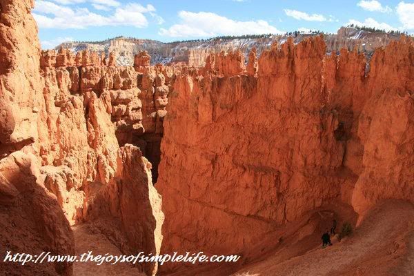
Hoodoos Keep on Haunting Me 1 Jul 2016 11:57 AM (8 years ago)


Bryce Canyon National Park is one of the 7 National Parks of the Southwest's Grand Circle. Its amazing beauty is the result of the destructive forces of water and ice carving away the weak limestone of the eastern edge of the Paunsaugunt Plateau. The result of this water, ice and gravity erosion brought about red rock spires and horshoe-shaped amphitheaters of hoodoos, which Bryce Canyon is known for.

Finding The Stretch of Purple Sand at Pfeiffer Beach, Big Sur, CA 19 Jun 2016 6:46 PM (8 years ago)


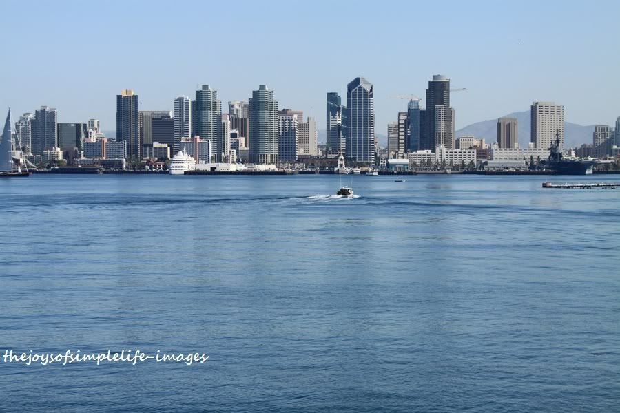
Into The San Diego Wild :) 8 Jun 2016 6:27 PM (8 years ago)

"I was in San Diego, but did not see those at all."
- I guess, it depends on which part of San Diego one focused their travel. Of course, if the focus was the "city", despite all the abundance of nature in and around San Diego, one may not be able to see them because they are not in downtown streets.
Anyway, let me share with you first a picture collage which somehow summarizes what is around San Diego.

%26bodytext%3D%3Cdiv%3E%0AYou%20may%20wonder%20why%20there%20is%20a%20smile%20:)%20symbol%20after%20the%20title.%20It%20is%20because%20it%20is%20not%20uncommon%20for%20me%20to%20get%20comments%20similar%20to%20the%20two%20below:%3Cbr%3E%0A%3Cbr%3E%0A%3Ci%3E%3Cb%3E%26quot;I%20was%20in%20San%20Diego,%20but%20did%20not%20see%20those%20at%20all.%26quot;%3C/b%3E%3C/i%3E%3Cbr%3E%0A-%20I%20guess,%20it%20depends%20on%20which%20part%20of%20San%20Diego%20one%20focused%20their%20travel.%20Of%20course,%20if%20the%20focus%20was%20the%20%3Cb%3E%26quot;city%26quot;%3C/b%3E,%20despite%20all%20the%20abundance%20of%20nature%20in%20and%20around%20San%20Diego,%20one%20may%20not%20be%20able%20to%20see%20them%20because%20they%20are%20not%20in%20downtown%20streets.%C2%A0%3C/div%3E%0A%3Cdiv%3E%0A%3Cbr%3E%3C/div%3E%0A%3Cdiv%3E%0A%3Ci%3E%3Cb%3E%26quot;You%20always%20take%20vacation.%20I%20do%20not%20have%20much%20time%20to%20get%20away%20as%20much%20as%20you%20do.%26quot;%3C/b%3E%3C/i%3E%3C/div%3E%0A%3Cdiv%3E%0A-%C2%A0%20One%20of%20my%20professors%20before%20told%20us,%20%26quot;San%20Diego%20is%20one%20of%20the%20most%20expensive%20places%20to%20live,%20you%20could%20get%20a%20place%20for%201/10th%20of%20the%20price%20and%2010times%20the%20size%20somewhere%20else.%20However,%20if%20you%20enjoy%20a%20balance%20of%20great%20outdoors%20and%20the%20city,%20this%20is%20your%20city.%20You%20don%26%2339;t%20need%20to%20take%20a%20vacation,%20for%20everyday%20is%20like%20a%20vacation.%20Considering%20vacation%20expenses,%20the%20price%20you%20are%20paying%20for%20to%20live%20in%20San%20Diego%20is%20not%20that%20expensive%20after%20all.%26quot;%C2%A0%20:)%3Cbr%3E%0A%3Cbr%3E%3C/div%3E%0AOftentimes,%20we%20are%20being%20mistaken%20to%20have%20a%20lifestyle%20that%20always%20take%20vacation.%20To%20quote%20a%20friend%20while%20I%20toured%20her%20around%20San%20Diego,%20she%20said,%20%26quot;Goodness,%20Betchai,%20I%20did%20not%20know%20these%20are%20all%20just%20within%20San%20Diego%20and%20minutes%20from%20your%20home.%20I%20thought%20all%20the%20while,%20every%20weekend,%20you%20take%20a%20vacation.%20Haaayst!%20Please%20pray%20I%20can%20find%20a%20job,%20HERE!%26quot;%3Cbr%3E%0A%3Cbr%3E%0AAnyway,%20let%20me%20share%20with%20you%20first%20a%20picture%20collage%20which%20somehow%20summarizes%20what%20is%20around%20San%20Diego.%3Cbr%3E%0A%3Cdiv%3E%0A%3Ca%20href%3D%22https://blogger.googleusercontent.com/img/b/R29vZ2xl/AVvXsEis3eykxpJSlmjdzMJTkcqZvYFgmgbZC52M4nnhrgjPmm1ocIPeeX6FpZileUDOCLgJuswjbpiuK3DqVc7qagEMHl_n7TyMiXDib58cU-eNQe6I-eaQf2jZN8hIxyTv-qzqkkfxp2oIqHY/s1600/Fotor0126201918.jpg%22%20imageanchor%3D%221%22%3E%3Cimg%20border%3D%220%22%20height%3D%22480%22%20src%3D%22https://blogger.googleusercontent.com/img/b/R29vZ2xl/AVvXsEis3eykxpJSlmjdzMJTkcqZvYFgmgbZC52M4nnhrgjPmm1ocIPeeX6FpZileUDOCLgJuswjbpiuK3DqVc7qagEMHl_n7TyMiXDib58cU-eNQe6I-eaQf2jZN8hIxyTv-qzqkkfxp2oIqHY/s1600/Fotor0126201918.jpg%22%20width%3D%22640%22%20/%3E%3C/a%3E%3C/div%3E%0A%3Ca%20href%3D%22http://www.thejoysofsimplelife.com/2014/01/into-san-diego-wild.html%23more%22%3EContinue%20Reading%C2%BB%3C/a%3E)
Bumpass Hell, Lassen Volcanic National Park 5 Jun 2016 6:28 PM (8 years ago)


Random thoughts, Random Pics 26 May 2016 1:00 PM (8 years ago)


%3C/div%3E%0A%3Cdiv%3E%0Athis%20amazing%20bird,%20and%20the%20other%20wildlife%20around%20La%20Jolla%20makes%20the%20time%20go%20by%20so%20quickly.%20%3C/div%3E%0A%3Cdiv%3E%0A%3Cbr%20/%3E%3C/div%3E%0A%3Cdiv%3E%0A%3Cbr%20/%3E%3C/div%3E)
Sea Otters 7 May 2016 11:15 AM (8 years ago)


)
Colors of Spring 9 Apr 2016 5:26 PM (9 years ago)
 California hills, valleys and mountains are ablaze in colors right now. It seems I just can't have enough of the colors of spring. Here are some pictures of spring colors from recently.


%3Cbr%20/%3E%0A%3Cdiv%3E%0A%3Ca%20href%3D%22https://blogger.googleusercontent.com/img/b/R29vZ2xl/AVvXsEhOrle-EUU44gs81JTxpGmrvNe3g_Wm_U23HSh53p3m1lEqQcdRW147iv1tei3b3q5_N-qBmCfy9gNSIRwQQ3Ro7ScS5L0jm1Y2OvwIWXgPiL2WBJ8BwYB2aXPpZbwI3lWBlppd3MhIg1w/s1600/figu.jpg%22%20imageanchor%3D%221%22%3E%3Cimg%20border%3D%220%22%20height%3D%22640%22%20src%3D%22https://blogger.googleusercontent.com/img/b/R29vZ2xl/AVvXsEhOrle-EUU44gs81JTxpGmrvNe3g_Wm_U23HSh53p3m1lEqQcdRW147iv1tei3b3q5_N-qBmCfy9gNSIRwQQ3Ro7ScS5L0jm1Y2OvwIWXgPiL2WBJ8BwYB2aXPpZbwI3lWBlppd3MhIg1w/s640/figu.jpg%22%20width%3D%22640%22%20/%3E%3C/a%3E%3C/div%3E%0AColors%20near%20and%20far.%3Cbr%20/%3E%0A%3Cdiv%3E%0A%3Ca%20href%3D%22https://blogger.googleusercontent.com/img/b/R29vZ2xl/AVvXsEjeFtHXV4gyHo_GM0UoeKG3KF2AAcpZn0OJEPTBxym9c-npTOfuZoW9_mjp8kCXvxH4kjJkxxTuw1Z7JKFOZkx0r3BGYUcEv-_9bmQZJwLY8mXydIKfKNIoIHobdYWYHU5wIk0hAB08hHA/s1600/lan.jpg%22%20imageanchor%3D%221%22%3E%3Cimg%20border%3D%220%22%20height%3D%22408%22%20src%3D%22https://blogger.googleusercontent.com/img/b/R29vZ2xl/AVvXsEjeFtHXV4gyHo_GM0UoeKG3KF2AAcpZn0OJEPTBxym9c-npTOfuZoW9_mjp8kCXvxH4kjJkxxTuw1Z7JKFOZkx0r3BGYUcEv-_9bmQZJwLY8mXydIKfKNIoIHobdYWYHU5wIk0hAB08hHA/s640/lan.jpg%22%20width%3D%22640%22%20/%3E%3C/a%3E%3C/div%3E%0AMulti%20colored%20hills%20from%20a%20mix%20of%20wildflowers:%20California%20poppies,%20lupines,%20and%20purple%20phacelias.%3Cbr%20/%3E%0A%3Cdiv%3E%0A%3Ca%20href%3D%22https://blogger.googleusercontent.com/img/b/R29vZ2xl/AVvXsEjPKPCsPT8WDqdQzaAvp_ui0a4qTJpRY3T_sfgJ8jAbuf1-Wf0AT_U4tKQoQCd4Tr_fhM_iyOxCtX3Bpxcm5aWGzI5qs_0VsNhz_tErPd7kj1OEFtz9vkdE15CsgN7B0c-NwQFdRXpr5GU/s1600/mm.jpg%22%20imageanchor%3D%221%22%3E%3Cimg%20border%3D%220%22%20height%3D%22426%22%20src%3D%22https://blogger.googleusercontent.com/img/b/R29vZ2xl/AVvXsEjPKPCsPT8WDqdQzaAvp_ui0a4qTJpRY3T_sfgJ8jAbuf1-Wf0AT_U4tKQoQCd4Tr_fhM_iyOxCtX3Bpxcm5aWGzI5qs_0VsNhz_tErPd7kj1OEFtz9vkdE15CsgN7B0c-NwQFdRXpr5GU/s640/mm.jpg%22%20width%3D%22640%22%20/%3E%3C/a%3E%3C/div%3E%0AA%20carpet%20of%20purple%20phacelia.)
Moro Rock, Sequoia National Park, CA 9 Apr 2016 5:19 PM (9 years ago)


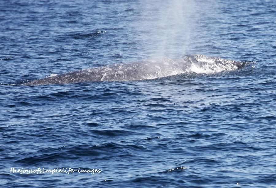
San Diego Whale Watching 9 Apr 2016 5:17 PM (9 years ago)


%3C/b%3E%3C/div%3E%0AIt%20has%20been%20an%20annual%20event%20for%20us%20to%20explore%20the%20Pacific%20Ocean%20from%20San%20Diego%20via%20Hornblower%20Cruise%20or%20H%26amp;M%20Landing.%20Last%20Christmas%20Holidays,%20we%20took%20a%20three-hour%20whale%20watching%20cruise,%20the%20earliest%20we%20had%20so%20far%20of%20the%20season.%20We%20took%20advantage%20of%20the%20promo%20we%20saw%20that%20gave%2050%25%20discount%20to%20San%20Diego%20Zoological%20Society's%20members.%20From%20$35,%20we%20only%20paid%20$17.50%20for%20a%203-hour%20whale%20watching%20cruise.%20Since%20the%20past%20four%20or%20five%20years%20that%20we%20had%20been%20whale%20watching%20every%20winter,%20we%20had%20never%20paid%20full%20price.%20Sometimes,%20we%20get%20discounted%20tickets%20from%20Gold%20Star.%20There%20were%20times%20we%20were%20able%20to%20save%20with%20a%20coupon%20from%20travelocity,%20which%20allowed%20us%20to%20save%20more%20than%2050%25.%20Aside%20from%20booking%20flights%20and%20hotels,%20travelocity%20also%20has%20connections%20in%20booking%20cruises%20and%20trains.%20Knowing%20that%20there%20are%20many%20deals%20we%20can%20find%20online,%20we%20never%20purchased%20tickets%20directly%20from%20the%20ticket%20booth%20but%20always%20purchased%20them%20online%20at%20much%20discounted%20prices.%3Cbr%20/%3E%0A%3Cdiv%3E%0A%3Ca%20href%3D%22http://img.photobucket.com/albums/v218/betchai_t/1b-1.jpg%22%20imageanchor%3D%221%22%3E%3Cimg%20border%3D%220%22%20src%3D%22http://img.photobucket.com/albums/v218/betchai_t/1b-1.jpg%22%20height%3D%22271%22%20width%3D%22400%22%20/%3E%3C/a%3E%3C/div%3E%0A%3Cdiv%3E%0A%3Cb%3EGray%20Whale%3C/b%3E%3C/div%3E%0A%3Cdiv%3E%0AWhale%20watching%20in%20San%20Diego%20usually%20starts%20from%20December%20to%20April.%20Over%2015,000%20gray%20whales%20migrate%20thousands%20of%20miles%20from%20the%20chilly%20Alaskan%20seas%20to%20the%20warm%20breeding%20lagoons%20of%20Baja%20California,%20Mexico.%20Aside%20from%20gray%20whales,%20other%20whales%20we%20would%20sometimes%20see%20are%20humpback%20whales,%20blue%20whales,%20and%20in%20rare%20occasions,%20orcas.%3C/div%3E%0A%3Cdiv%3E%0A%3Cbr%20/%3E%3C/div%3E%0A%3Cdiv%3E%0ASo%20that%20I%20will%20not%20overload%20you%20with%20pictures,%20for%20a%20change,%20here%20is%20a%20slideshow%20I%20made%20of%20our%203-hr%20whale%20watching%20cruise%20sometime%20last%20Christmas%20holidays.%3C/div%3E%0A%3Cdiv%3E%0A%3Cbr%20/%3E%3C/div%3E%0A%3Cdiv%3E%0AThe%20dolphins%20are%20always%20an%20added%20bonus%20to%20the%20whale%20watching%20tour%20and%20it%20seems%20they%20are%20always%20the%20first%20ones%20you%20will%20see%20in%20the%20cruise.%20In%20fact,%20the%20whale%20watching%20cruises%20are%20guaranteed%20whale%20watching%20trips,%20if%20no%20whales%20or%20insignificant%20showmanship%20from%20whales%20are%20sighted,%20everyone%20in%20the%20cruise%20gets%20another%20free%20ticket%20for%20another%20whale%20watching%20cruise%20that%20will%20expire%20in%20a%20year.%20If%20whales%20are%20more%20solitary,%20and%20the%20boat%20could%20not%20get%20near%20them%20following%20federal%20law%20on%20whale%20watching,%20the%20dolphins%20on%20the%20hand%20always%20have%20a%20whale%20of%20a%20good%20time%20following%20the%20boat.%20They%20seem%20to%20rejoice%20always%20whenever%20there%20is%20a%20boat,%20and%20they%20love%20to%20ride%20the%20bow%20wave.%3C/div%3E%0A%3Cdiv%3E%0A%3Ca%20href%3D%22https://blogger.googleusercontent.com/img/b/R29vZ2xl/AVvXsEg5QJNFCcsdBsct60tsN_iN6VSc1Umce8hyphenhyphenMhs8BhRa9c3DclrG_U6OcanCUoY2zpydc_563T0qtyqaq7zchuD0FVwG0JDeKxrnhLhSEKWwdIF9lRvdrwDFVWjLQyRiJJ-08UkIJHdjcYA/s1600/9b.JPG%22%20imageanchor%3D%221%22%3E%3Cimg%20border%3D%220%22%20height%3D%22266%22%20src%3D%22https://blogger.googleusercontent.com/img/b/R29vZ2xl/AVvXsEg5QJNFCcsdBsct60tsN_iN6VSc1Umce8hyphenhyphenMhs8BhRa9c3DclrG_U6OcanCUoY2zpydc_563T0qtyqaq7zchuD0FVwG0JDeKxrnhLhSEKWwdIF9lRvdrwDFVWjLQyRiJJ-08UkIJHdjcYA/s400/9b.JPG%22%20width%3D%22400%22%20/%3E%3C/a%3E%3C/div%3E%0A%3Cdiv%3E%0A%3Cb%3EDolphins%20Enjoying%20the%20Bow%20Wave%3C/b%3E%3C/div%3E%0A%3Cdiv%3E%0AThere%20are%20several%20companies%20that%20offer%20whale%20watching%20tours%20and%20excursions%20for%20up-close%20viewing%20of%20the%20whales.%20Because%20of%20these%20competition%20from%20various%20whale%20watching%20tour%20companies,%20coupons%20are%20not%20hard%20to%20find.%20We%20do%20not%20subscribe%20to%20any%20newspaper%20company%20because%20we%20can%20access%20newspaper%20online%20for%20free,%20therefore,%20we%20scout%20for%20coupons%20not%20on%20newspaper%20anymore%20but%20using%20sites%20that%20shares%20their%20coupon%20finds%20online.%26nbsp;I%20oftentimes%20would%20go%20to%20Frugal%20Dad%20to%20check%20out%20coupons%20which%20are%20not%20limited%20to%20cruises%20only%20but%20to%20almost%20all%20other%20needs.%26nbsp;We%20however%20are%20not%20really%20crazy%20about%20coupons,%20we%20only%20use%20it%20if%20we%20really%20have%20to%20use%20it.%20Otherwise,%20if%20there%20is%20no%20need,%20despite%20it%20is%20a%20steal,%20we%20hold%20off%20from%20spending%20unnecessary%20things%20and%20collect%20junk%20at%20home.%20But%20whale%20watching,%20is%20one%20of%20those%20priceless%20memories,%20that%20we%20use%20the%20coupon%20every%20year!%20For%20every%20year,%20is%20different,%20and%20special!%0A%3C/div%3E%0A%3Cdiv%3E%0A%3Ca%20href%3D%22https://blogger.googleusercontent.com/img/b/R29vZ2xl/AVvXsEhNP19D_fQKw9Zb_JMHD8z8nORBiXb9ecANy_Vm13JBcNhO-279qUtzZvJfdtvc9dQEjt-VgFjDsYYo7bFasxKFTYvgBaxHNGY77SQqg2_SXluYI-UkDTWLFbc0Sc8QkQJ3X326XZMSoxA/s1600/day+2+stephen+and+sue68.JPG%22%20imageanchor%3D%221%22%3E%3Cimg%20border%3D%220%22%20height%3D%22266%22%20src%3D%22https://blogger.googleusercontent.com/img/b/R29vZ2xl/AVvXsEhNP19D_fQKw9Zb_JMHD8z8nORBiXb9ecANy_Vm13JBcNhO-279qUtzZvJfdtvc9dQEjt-VgFjDsYYo7bFasxKFTYvgBaxHNGY77SQqg2_SXluYI-UkDTWLFbc0Sc8QkQJ3X326XZMSoxA/s400/day+2+stephen+and+sue68.JPG%22%20width%3D%22400%22%20/%3E%3C/a%3E%3C/div%3E%0A%3Cdiv%3E%0A%3Cb%3ESunset%20Back%20To%20Shore%3C/b%3E%3C/div%3E%0A%3Cdiv%3E%0A%3Cbr%20/%3E%3C/div%3E%0A%3Cbr%20/%3E)
Grey Whales and California Condors sightings from Big Sur cliffs 3 Apr 2016 5:23 PM (9 years ago)


The Valley of Fire Wave 28 Mar 2016 9:00 PM (9 years ago)


Pink 5 Mar 2016 7:34 PM (9 years ago)
 It's been a while since I last posted here. Anyway, let me share my very simple joy today. Imagine my happiness when I saw lovely pink trees blooming all around. And the cherry blossoms in Japanese Garden at Balboa Park were just so lovely. My cell phone almost ran out of battery and memory from snapping photos. Here are some of them.


%20Simple%20joy,%20but%20am%20overjoyed.%20Hope%20you%20don't%20mind%20I'm%20saturating%20this%20post%20with%20pink.%20:)%3C/div%3E%3Cdiv%3E%3Cbr%3E%3C/div%3E%3Cdiv%3E%3Cbr%3E%3C/div%3E%3Cbr%3E%3C/div%3E%3Cbr%3E%3C/div%3E%3Cbr%3E%3C/div%3E%3Cbr%3E%3C/div%3E)
Lake Hodges Recently 2 Feb 2016 6:51 PM (9 years ago)
 I apologize for not being so present here in the blogosphere, somehow I am so swamped with work that I go home to work still. However, despite of the craziness, I do take time to take care of my health and fitness of mind and body by spending time with nature on weekends hiking. Here are some photos of my hikes recently.


Morning Has Broken 2 Feb 2016 6:42 PM (9 years ago)


What a beautiful morning life always give us, we just have to come appreciate every moment.

Gibbon Falls, Yellowstone National Park 26 Jan 2016 6:21 PM (9 years ago)


Wandering from Water to Land 10 Jan 2016 5:51 AM (9 years ago)

When I was still a kid, whenever I saw my mom looking for me, I would hide myself in the water. It was always a sad time to go home for home was out in the ocean for me. Thankfully, my concept of home expanded as I grew older. Though I still love the ocean, but I learned to love the mountains, the rivers, the woods, the desert, that home now for me extends everywhere. :) I don't need to travel far to enjoy nature for nature is everywhere, and in nature I feel I am home. Even indoors at home, I still could enjoy the sounds of nature from the joyful singing of the birds and enjoy their wonderful and beautiful sight from the window.
 |
| Finding Nature at Home ( birds from the backyard ) |
%20Last%20Saturday%20was%20our%20first%20time%20for%20the%20year%202015%20to%20get%20into%20the%20water%20again.%20Oh%20boy,%20how%20I%20miss%20being%20in%20the%20water.%20If%20only%20the%20water%20does%20not%20get%20colder%20the%20longer%20I%20stay,%20I%20would%20stay%20in%20the%20water%20for%20as%20long%20as%20I%20could.%3Cbr%3E%0A%3Cbr%3E%0AWhen%20I%20was%20still%20a%20kid,%20whenever%20I%20saw%20my%20mom%20looking%20for%20me,%20I%20would%20hide%20myself%20in%20the%20water.%20It%20was%20always%20a%20sad%20time%20to%20go%20home%20for%20home%20was%20out%20in%20the%20ocean%20for%20me.%20Thankfully,%20my%20concept%20of%20home%20expanded%20as%20I%20grew%20older.%20Though%20I%20still%20love%20the%20ocean,%20but%20I%20learned%20to%20love%20the%20mountains,%20the%20rivers,%20the%20woods,%20the%20desert,%20that%20home%20now%20for%20me%20extends%20everywhere.%20:)%20%C2%A0I%20don%26%2339;t%20need%20to%20travel%20far%20to%20enjoy%20nature%20for%20nature%20is%20everywhere,%20and%20in%20nature%20I%20feel%20I%20am%20home.%20Even%20indoors%20at%20home,%20I%20still%20could%20enjoy%20the%20sounds%20of%20nature%20from%20the%20joyful%20singing%20of%20the%20birds%20and%20enjoy%20their%20wonderful%20and%20beautiful%20sight%20from%20the%20window.%3C/div%3E%0A%3Ctable%20align%3D%22center%22%20cellpadding%3D%220%22%20cellspacing%3D%220%22%3E%3Ctbody%3E%0A%3Ctr%3E%3Ctd%3E%3Ca%20href%3D%22https://blogger.googleusercontent.com/img/b/R29vZ2xl/AVvXsEhX-MPuzkYGvJDEseNd0fxNaCNAz9ditsp_mhPJoZMnFj46u7RwdOQyDB4LKsIYpyrT9CeflXeS1D0M-IB8ZEVbrKXFrLHjtrsHYoV3FSM4jv0yliEoLv8Ra453Hg2HB6Sm-EFg4-8Xnvk/s1600/O84A2665.JPG%22%20imageanchor%3D%221%22%3E%3Cimg%20border%3D%220%22%20height%3D%22404%22%20src%3D%22https://blogger.googleusercontent.com/img/b/R29vZ2xl/AVvXsEhX-MPuzkYGvJDEseNd0fxNaCNAz9ditsp_mhPJoZMnFj46u7RwdOQyDB4LKsIYpyrT9CeflXeS1D0M-IB8ZEVbrKXFrLHjtrsHYoV3FSM4jv0yliEoLv8Ra453Hg2HB6Sm-EFg4-8Xnvk/s640/O84A2665.JPG%22%20width%3D%22640%22%20/%3E%3C/a%3E%3C/td%3E%3C/tr%3E%0A%3Ctr%3E%3Ctd%3E%3Cb%3E%3Ci%3E%3Cspan%3EFinding%20Nature%20at%20Home%20(%20birds%20from%20the%20backyard%20)%3C/span%3E%3C/i%3E%3C/b%3E%3Cbr%3E%0A%3C/td%3E%3C/tr%3E%3C/tbody%3E%3C/table%3E%3Ca%20href%3D%22http://www.thejoysofsimplelife.com/2015/07/wandering-from-water-to-land.html%23more%22%3EContinue%20Reading%C2%BB%3C/a%3E)
Halema‘uma‘u Crater, Kilauea Volcano, Big Island, Hawaii 6 Dec 2015 6:38 PM (9 years ago)
 play of colors at Halema‘uma‘u Crater, Kilauea Volcano, Big Island, Hawai'i Volcanoes National Park.

top right: Halema'uma'u Crater lighting the sky at dawn
middle right: sunrise
bottom right: crater lighting the sky at night
Bottom and middle left: thick clouds above the volcano

Sunset Walk 9 Nov 2015 6:07 PM (9 years ago)


It Was a Flying Sundate 9 Nov 2015 5:58 PM (9 years ago)


